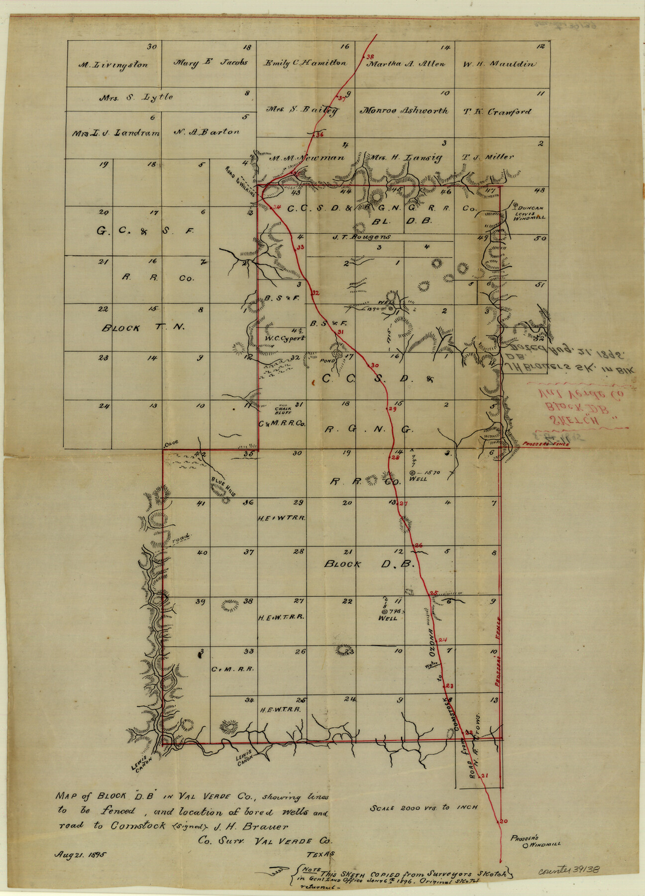
Val Verde County Sketch File Z11
[Sketch of Block DB northwest from Del Rio]
-
Map/Doc
39138
-
Collection
General Map Collection
-
Object Dates
8/21/1895 (Creation Date)
-
People and Organizations
J.H. Brauer (Surveyor/Engineer)
-
Counties
Val Verde
-
Subjects
Surveying Sketch File
-
Height x Width
17.6 x 12.7 inches
44.7 x 32.3 cm
-
Medium
paper, manuscript
-
Scale
1" = 2000 varas
-
Features
Road to Wilkins
Blue Hills
Chalk Bluff
Road from Comstock to Ozona
Part of: General Map Collection
Maverick County Working Sketch 20

Print $20.00
- Digital $50.00
Maverick County Working Sketch 20
1977
Size 26.1 x 22.0 inches
Map/Doc 70912
[Cotton Belt, St. Louis Southwestern Railway of Texas, Alignment through Smith County]
![64384, [Cotton Belt, St. Louis Southwestern Railway of Texas, Alignment through Smith County], General Map Collection](https://historictexasmaps.com/wmedia_w700/maps/64384.tif.jpg)
Print $20.00
- Digital $50.00
[Cotton Belt, St. Louis Southwestern Railway of Texas, Alignment through Smith County]
1903
Size 21.4 x 29.9 inches
Map/Doc 64384
Bandera County Working Sketch 46

Print $20.00
- Digital $50.00
Bandera County Working Sketch 46
1981
Size 28.0 x 37.4 inches
Map/Doc 67642
Flight Mission No. BQY-4M, Frame 37, Harris County

Print $20.00
- Digital $50.00
Flight Mission No. BQY-4M, Frame 37, Harris County
1953
Size 18.6 x 22.3 inches
Map/Doc 85252
Garza County Rolled Sketch 6A

Print $20.00
- Digital $50.00
Garza County Rolled Sketch 6A
1902
Size 29.2 x 35.9 inches
Map/Doc 9053
Map of Crockett County

Print $40.00
- Digital $50.00
Map of Crockett County
1878
Size 62.5 x 51.1 inches
Map/Doc 93372
Hill County Sketch File 25

Print $4.00
- Digital $50.00
Hill County Sketch File 25
Size 7.9 x 10.9 inches
Map/Doc 26520
Tom Green County Sketch File 55 1/2

Print $20.00
- Digital $50.00
Tom Green County Sketch File 55 1/2
1886
Size 26.4 x 13.6 inches
Map/Doc 12443
[Surveys by Brown in Austin's Little Colony along the Colorado River and Walnut Creek]
![196, [Surveys by Brown in Austin's Little Colony along the Colorado River and Walnut Creek], General Map Collection](https://historictexasmaps.com/wmedia_w700/maps/196.tif.jpg)
Print $20.00
- Digital $50.00
[Surveys by Brown in Austin's Little Colony along the Colorado River and Walnut Creek]
1832
Size 33.2 x 23.3 inches
Map/Doc 196
Brewster County Rolled Sketch 9

Print $40.00
- Digital $50.00
Brewster County Rolled Sketch 9
Size 38.7 x 67.5 inches
Map/Doc 8468
Bell County Sketch File 24

Print $4.00
- Digital $50.00
Bell County Sketch File 24
Size 10.0 x 8.0 inches
Map/Doc 14418

You may also like
General Highway Map. Detail of Cities and Towns in Nueces County, Texas [Corpus Christi and vicinity]
![79617, General Highway Map. Detail of Cities and Towns in Nueces County, Texas [Corpus Christi and vicinity], Texas State Library and Archives](https://historictexasmaps.com/wmedia_w700/maps/79617.tif.jpg)
Print $20.00
General Highway Map. Detail of Cities and Towns in Nueces County, Texas [Corpus Christi and vicinity]
1961
Size 24.6 x 18.1 inches
Map/Doc 79617
Map of Texas. The Proposed Reoccupation of the Rio Grande -- Its Importance to the Union

Print $20.00
Map of Texas. The Proposed Reoccupation of the Rio Grande -- Its Importance to the Union
1965
Size 14.1 x 8.6 inches
Map/Doc 76264
Wharton County Rolled Sketch 6

Print $20.00
- Digital $50.00
Wharton County Rolled Sketch 6
1901
Size 23.7 x 30.0 inches
Map/Doc 8230
Flight Mission No. BRA-3M, Frame 128, Jefferson County

Print $20.00
- Digital $50.00
Flight Mission No. BRA-3M, Frame 128, Jefferson County
1953
Size 18.5 x 22.3 inches
Map/Doc 85402
[Mary Fury and B. H. Epperson surveys]
![93066, [Mary Fury and B. H. Epperson surveys], Twichell Survey Records](https://historictexasmaps.com/wmedia_w700/maps/93066-1.tif.jpg)
Print $3.00
- Digital $50.00
[Mary Fury and B. H. Epperson surveys]
1919
Size 10.6 x 14.6 inches
Map/Doc 93066
Hockley County Sketch, Mineral Application Number 39180

Print $3.00
- Digital $50.00
Hockley County Sketch, Mineral Application Number 39180
1947
Size 10.4 x 12.8 inches
Map/Doc 91106
La Salle County Working Sketch 52

Print $40.00
- Digital $50.00
La Salle County Working Sketch 52
1963
Size 53.5 x 43.0 inches
Map/Doc 70353
[Capitol League Lands in SE corner of Lamb County and along the north line of Lamb and Bailey]
![90244, [Capitol League Lands in SE corner of Lamb County and along the north line of Lamb and Bailey], Twichell Survey Records](https://historictexasmaps.com/wmedia_w700/maps/90244-1.tif.jpg)
Print $20.00
- Digital $50.00
[Capitol League Lands in SE corner of Lamb County and along the north line of Lamb and Bailey]
Size 27.7 x 19.7 inches
Map/Doc 90244
Erath County Working Sketch 50b

Print $20.00
- Digital $50.00
Erath County Working Sketch 50b
Size 43.4 x 25.8 inches
Map/Doc 69132
Hutchinson County Sketch File 4a

Print $7.00
- Digital $50.00
Hutchinson County Sketch File 4a
Size 25.9 x 43.8 inches
Map/Doc 10625
Real County Working Sketch 11

Print $20.00
- Digital $50.00
Real County Working Sketch 11
1929
Size 25.8 x 35.6 inches
Map/Doc 71903
Moore County Working Sketch 2

Print $20.00
- Digital $50.00
Moore County Working Sketch 2
1934
Size 18.3 x 41.3 inches
Map/Doc 71184