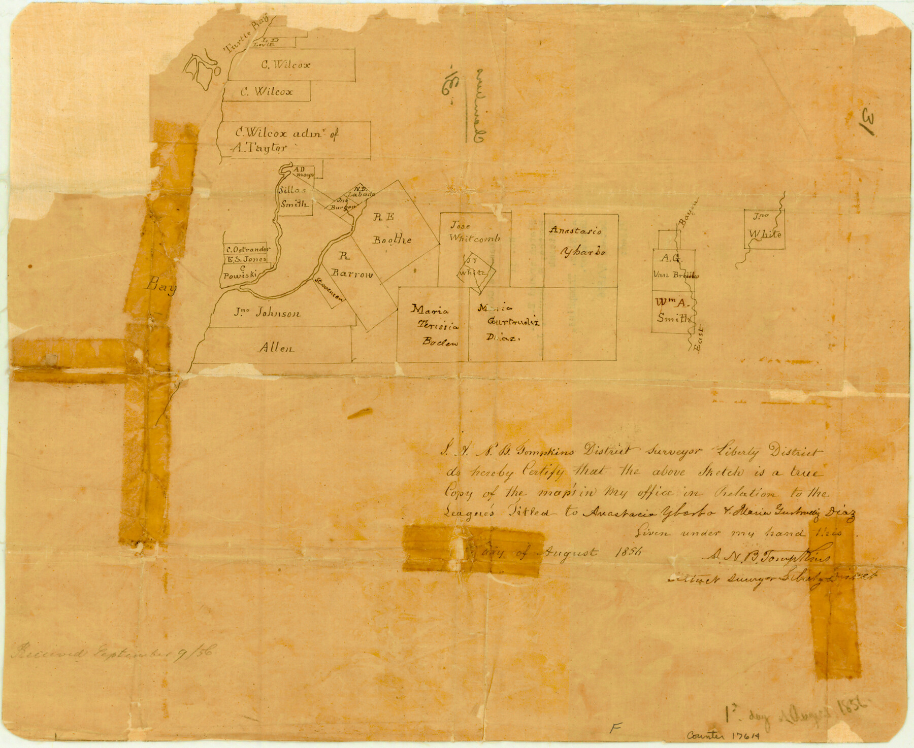
Chambers County Sketch File 31
[Sketch of area around R.E. Boothe, R. Barrow, and Jose Whitcomb surveys]
-
Map/Doc
17614
-
Collection
General Map Collection
-
Object Dates
1856 (Creation Date)
-
People and Organizations
A.N.B. Tompkins (Surveyor/Engineer)
-
Counties
Chambers
-
Subjects
Surveying Sketch File
-
Height x Width
12.4 x 15.2 inches
31.5 x 38.6 cm
-
Medium
paper, manuscript
-
Features
Turtle Bay
East Bayou
Part of: General Map Collection
Flight Mission No. DQN-3K, Frame 33, Calhoun County

Print $20.00
- Digital $50.00
Flight Mission No. DQN-3K, Frame 33, Calhoun County
1953
Size 18.6 x 22.3 inches
Map/Doc 84346

Concho County Working Sketch 8

Print $20.00
- Digital $50.00
Concho County Working Sketch 8
1948
Size 47.0 x 42.6 inches
Map/Doc 68190

Galveston Harbor and Channel, Texas - Rehabilitation of Galveston Groins - Location Plan of Rehabilitation

Print $4.00
- Digital $50.00
Galveston Harbor and Channel, Texas - Rehabilitation of Galveston Groins - Location Plan of Rehabilitation
1968
Size 16.0 x 20.6 inches
Map/Doc 73620
Gregg County Rolled Sketch 17

Print $20.00
- Digital $50.00
Gregg County Rolled Sketch 17
1933
Size 14.0 x 27.9 inches
Map/Doc 6040
Flight Mission No. BRE-1P, Frame 137, Nueces County

Print $20.00
- Digital $50.00
Flight Mission No. BRE-1P, Frame 137, Nueces County
1956
Size 18.7 x 22.6 inches
Map/Doc 86697
Brooks County Working Sketch 7

Print $20.00
- Digital $50.00
Brooks County Working Sketch 7
1928
Size 35.6 x 27.1 inches
Map/Doc 67791
Bowie County Working Sketch 29

Print $20.00
- Digital $50.00
Bowie County Working Sketch 29
1991
Size 36.9 x 47.7 inches
Map/Doc 67433

Blanco County Rolled Sketch 19

Print $20.00
- Digital $50.00
Blanco County Rolled Sketch 19
Size 20.4 x 17.0 inches
Map/Doc 76409
Armstrong County Sketch File 1

Print $4.00
- Digital $50.00
Armstrong County Sketch File 1
Size 8.1 x 10.6 inches
Map/Doc 13685
You may also like
Hudspeth County Working Sketch 23

Print $40.00
- Digital $50.00
Hudspeth County Working Sketch 23
1967
Size 52.7 x 34.3 inches
Map/Doc 69650
Knox County Rolled Sketch 21

Print $20.00
- Digital $50.00
Knox County Rolled Sketch 21
1955
Size 18.0 x 36.4 inches
Map/Doc 6561
Tom Green County

Print $40.00
- Digital $50.00
Tom Green County
Size 43.6 x 111.2 inches
Map/Doc 82058
Revised Map of Matagorda Bay and Vicinity in Matagorda and Calhoun Counties showing subdivision for mineral development

Print $40.00
- Digital $50.00
Revised Map of Matagorda Bay and Vicinity in Matagorda and Calhoun Counties showing subdivision for mineral development
1941
Size 44.3 x 60.0 inches
Map/Doc 2933
Cooke County Working Sketch 34

Print $20.00
- Digital $50.00
Cooke County Working Sketch 34
1984
Size 41.7 x 38.0 inches
Map/Doc 68271

Cameron County Rolled Sketch 25

Print $20.00
- Digital $50.00
Cameron County Rolled Sketch 25
1977
Size 24.7 x 36.7 inches
Map/Doc 5795
Flight Mission No. CUG-1P, Frame 51, Kleberg County

Print $20.00
- Digital $50.00
Flight Mission No. CUG-1P, Frame 51, Kleberg County
1956
Size 18.7 x 22.3 inches
Map/Doc 86129
Map of Robertson District

Print $40.00
- Digital $50.00
Map of Robertson District
1846
Size 81.3 x 45.3 inches
Map/Doc 3032
[Section 2, Block 5, Dawson County, Texas]
![92617, [Section 2, Block 5, Dawson County, Texas], Twichell Survey Records](https://historictexasmaps.com/wmedia_w700/maps/92617-1.tif.jpg)
Print $2.00
- Digital $50.00
[Section 2, Block 5, Dawson County, Texas]
Size 9.2 x 12.3 inches
Map/Doc 92617
Map Showing Corrections of Capitol Leagues in Conflict in Oldham Co.

Print $40.00
- Digital $50.00
Map Showing Corrections of Capitol Leagues in Conflict in Oldham Co.
1886
Size 52.5 x 31.3 inches
Map/Doc 89800
Leon County Working Sketch 52a

Print $20.00
- Digital $50.00
Leon County Working Sketch 52a
1982
Size 35.1 x 42.8 inches
Map/Doc 70451