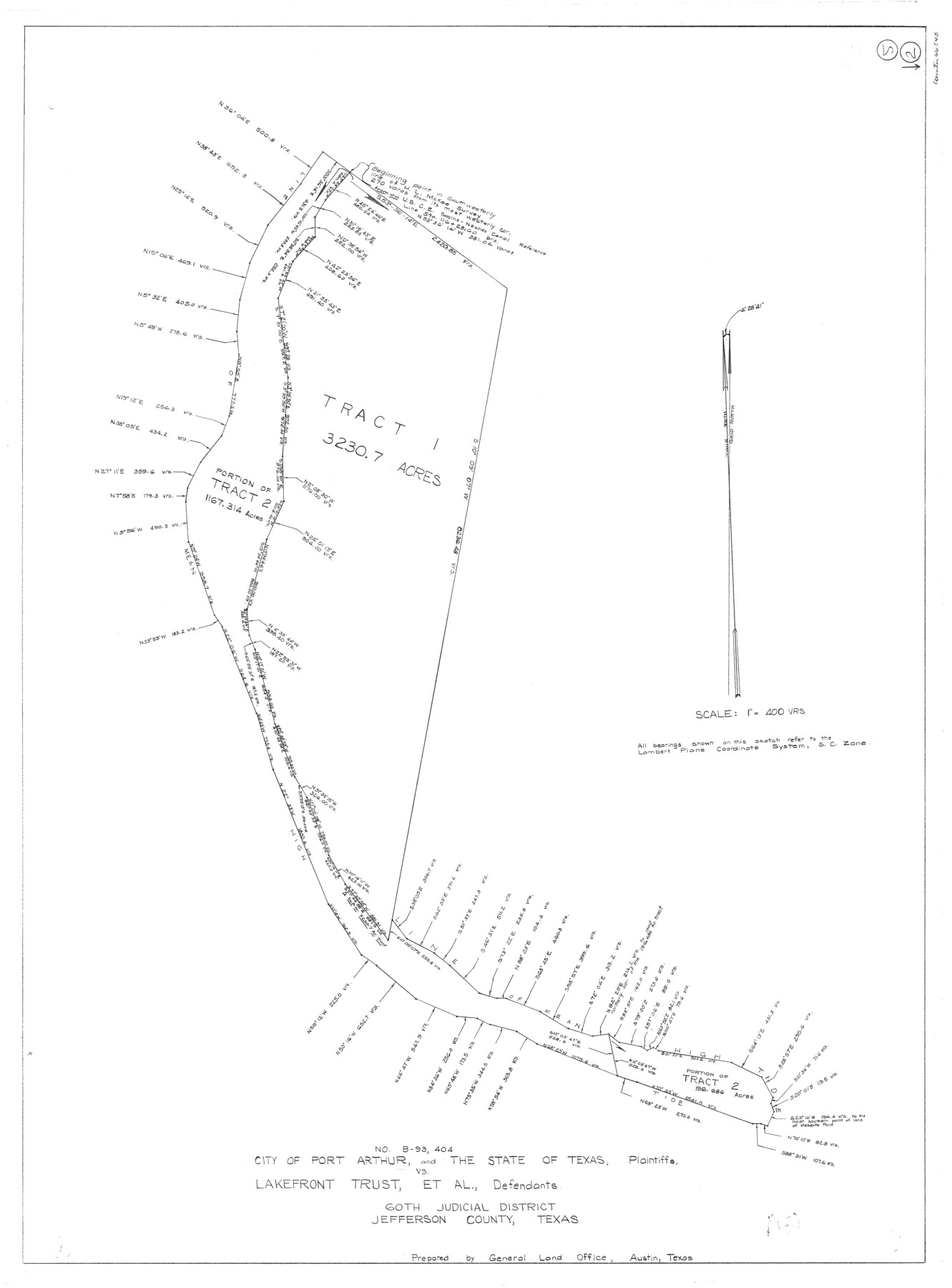
Jefferson County Working Sketch 2
-
Map/Doc
66545
-
Collection
General Map Collection
-
Counties
Jefferson
-
Subjects
Surveying Working Sketch
-
Height x Width
40.0 x 29.6 inches
101.6 x 75.2 cm
-
Scale
1" = 400 varas
Part of: General Map Collection
Sterling County Working Sketch 10

Print $20.00
- Digital $50.00
Sterling County Working Sketch 10
1980
Size 39.6 x 26.3 inches
Map/Doc 63992
Hockley County

Print $20.00
- Digital $50.00
Hockley County
1954
Size 42.7 x 38.2 inches
Map/Doc 73181
Colorado County Sketch File 28

Print $17.00
- Digital $50.00
Colorado County Sketch File 28
1935
Size 9.1 x 7.7 inches
Map/Doc 18966
Sabine Bank to East Bay including Heald Bank

Print $20.00
- Digital $50.00
Sabine Bank to East Bay including Heald Bank
1973
Size 44.8 x 34.5 inches
Map/Doc 69850
Dickens County Rolled Sketch 12

Print $20.00
- Digital $50.00
Dickens County Rolled Sketch 12
1959
Size 33.5 x 39.7 inches
Map/Doc 8790
Flight Mission No. CUG-2P, Frame 12, Kleberg County

Print $20.00
- Digital $50.00
Flight Mission No. CUG-2P, Frame 12, Kleberg County
1956
Size 18.6 x 22.1 inches
Map/Doc 86184
Swisher County Boundary File 2

Print $106.00
- Digital $50.00
Swisher County Boundary File 2
Size 14.3 x 9.0 inches
Map/Doc 59093
Bosque County Working Sketch 32

Print $20.00
- Digital $50.00
Bosque County Working Sketch 32
2014
Size 24.3 x 24.7 inches
Map/Doc 93687

Pecos County Working Sketch 123

Print $20.00
- Digital $50.00
Pecos County Working Sketch 123
1973
Size 42.4 x 24.2 inches
Map/Doc 71596
Edwards County Working Sketch 130

Print $20.00
- Digital $50.00
Edwards County Working Sketch 130
1982
Size 29.3 x 26.8 inches
Map/Doc 69006
Hudspeth County Sketch File 29

Print $20.00
- Digital $50.00
Hudspeth County Sketch File 29
1918
Size 22.3 x 21.4 inches
Map/Doc 11804
You may also like
Randall County Rolled Sketch 9

Print $20.00
- Digital $50.00
Randall County Rolled Sketch 9
Size 47.5 x 35.8 inches
Map/Doc 9808
Williamson County Working Sketch 5

Print $20.00
- Digital $50.00
Williamson County Working Sketch 5
1919
Size 23.4 x 18.3 inches
Map/Doc 72565
[Terry County Highways]
![92905, [Terry County Highways], Twichell Survey Records](https://historictexasmaps.com/wmedia_w700/maps/92905-1.tif.jpg)
Print $20.00
- Digital $50.00
[Terry County Highways]
Size 17.0 x 16.8 inches
Map/Doc 92905
Flight Mission No. CGI-3N, Frame 168, Cameron County

Print $20.00
- Digital $50.00
Flight Mission No. CGI-3N, Frame 168, Cameron County
1954
Size 18.5 x 22.6 inches
Map/Doc 84632
Tarrant County Working Sketch 9

Print $20.00
- Digital $50.00
Tarrant County Working Sketch 9
1986
Size 38.1 x 42.1 inches
Map/Doc 62426
Kent County Working Sketch 16

Print $20.00
- Digital $50.00
Kent County Working Sketch 16
1972
Size 32.4 x 31.5 inches
Map/Doc 70023
Menard County Working Sketch 34

Print $20.00
- Digital $50.00
Menard County Working Sketch 34
2003
Size 27.1 x 44.4 inches
Map/Doc 82028
Texas-United States Boundary Line 1

Print $4.00
- Digital $50.00
Texas-United States Boundary Line 1
1843
Size 12.6 x 7.8 inches
Map/Doc 74974
Van Zandt County Sketch File 24a

Print $4.00
- Digital $50.00
Van Zandt County Sketch File 24a
1858
Size 6.2 x 8.1 inches
Map/Doc 39441

Webb County Working Sketch 30

Print $20.00
- Digital $50.00
Webb County Working Sketch 30
1934
Size 15.0 x 40.6 inches
Map/Doc 72395
Collingsworth County

Print $20.00
- Digital $50.00
Collingsworth County
1880
Size 24.9 x 20.0 inches
Map/Doc 3420