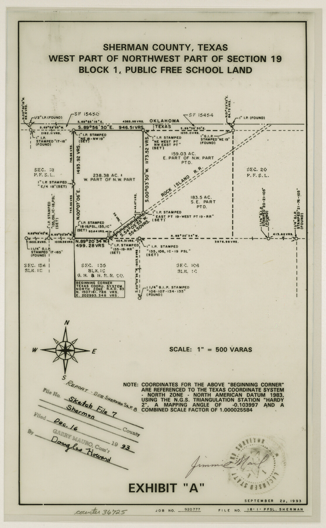
Sherman County Sketch File 7
[Sketch of west part of northwest part of section 19, Block 1, Public Free School Land]
-
Map/Doc
36725
-
Collection
General Map Collection
-
Object Dates
1993 (Creation Date)
1993/12/16 (File Date)
1993/9/29 (Creation Date)
-
People and Organizations
Jimmie Nail (Surveyor/Engineer)
-
Counties
Sherman
-
Subjects
Surveying Sketch File
-
Height x Width
14.6 x 9.0 inches
37.1 x 22.9 cm
-
Medium
mylar, print
-
Scale
1" = 500 varas
-
Comments
See Sherman County Sketch File 8 (36726) for report.
Related maps
Sherman County Sketch File 8

Print $61.00
- Digital $50.00
Sherman County Sketch File 8
1993
Size 11.4 x 8.9 inches
Map/Doc 36726
Part of: General Map Collection
Dimmit County Working Sketch 52

Print $20.00
- Digital $50.00
Dimmit County Working Sketch 52
1989
Size 25.2 x 37.0 inches
Map/Doc 68713
Upton County Rolled Sketch 40

Print $20.00
- Digital $50.00
Upton County Rolled Sketch 40
Size 26.2 x 39.7 inches
Map/Doc 8079
Leon County Working Sketch 55

Print $20.00
- Digital $50.00
Leon County Working Sketch 55
1989
Size 18.7 x 18.3 inches
Map/Doc 70455
Intracoastal Waterway in Texas - Corpus Christi to Point Isabel including Arroyo Colorado to Mo. Pac. R.R. Bridge Near Harlingen

Print $20.00
- Digital $50.00
Intracoastal Waterway in Texas - Corpus Christi to Point Isabel including Arroyo Colorado to Mo. Pac. R.R. Bridge Near Harlingen
1933
Size 27.9 x 40.7 inches
Map/Doc 61863
McCulloch County

Print $40.00
- Digital $50.00
McCulloch County
1949
Size 48.4 x 37.5 inches
Map/Doc 95584
Runnels County Rolled Sketch 41

Print $20.00
- Digital $50.00
Runnels County Rolled Sketch 41
Size 26.1 x 29.8 inches
Map/Doc 7529
Hardin County Sketch File 16a

Print $3.00
- Digital $50.00
Hardin County Sketch File 16a
1837
Size 10.4 x 16.0 inches
Map/Doc 25129
Flight Mission No. BRA-8M, Frame 65, Jefferson County

Print $20.00
- Digital $50.00
Flight Mission No. BRA-8M, Frame 65, Jefferson County
1953
Size 18.6 x 22.4 inches
Map/Doc 85585
Edwards County Sketch File 10

Print $40.00
- Digital $50.00
Edwards County Sketch File 10
Size 26.3 x 19.0 inches
Map/Doc 11421
Jeff Davis County Sketch File 35

Print $20.00
- Digital $50.00
Jeff Davis County Sketch File 35
1950
Size 20.6 x 19.2 inches
Map/Doc 11866
Gaines County Sketch File 14

Print $20.00
- Digital $50.00
Gaines County Sketch File 14
1954
Size 23.4 x 32.1 inches
Map/Doc 11525
Atascosa County Boundary File 1

Print $14.00
- Digital $50.00
Atascosa County Boundary File 1
Size 12.9 x 8.3 inches
Map/Doc 50153
You may also like
Aerial Perspective of Packery Channel

Print $20.00
- Digital $50.00
Aerial Perspective of Packery Channel
1938
Size 16.5 x 19.3 inches
Map/Doc 3001
Flight Mission No. CRC-4R, Frame 74, Chambers County

Print $20.00
- Digital $50.00
Flight Mission No. CRC-4R, Frame 74, Chambers County
1956
Size 18.7 x 22.5 inches
Map/Doc 84878
Amistad International Reservoir on Rio Grande 66

Print $20.00
- Digital $50.00
Amistad International Reservoir on Rio Grande 66
1949
Size 28.5 x 39.6 inches
Map/Doc 73351
Hays County Working Sketch 20

Print $40.00
- Digital $50.00
Hays County Working Sketch 20
1980
Size 42.9 x 65.6 inches
Map/Doc 66094
El Paso County State Real Property Sketch 4

Print $20.00
- Digital $50.00
El Paso County State Real Property Sketch 4
2012
Size 29.9 x 35.9 inches
Map/Doc 93701
El Paso County Working Sketch 12

Print $20.00
- Digital $50.00
El Paso County Working Sketch 12
1956
Size 33.0 x 41.4 inches
Map/Doc 69034
Garza County Rolled Sketch R3

Print $20.00
- Digital $50.00
Garza County Rolled Sketch R3
Size 21.4 x 14.9 inches
Map/Doc 6006

Erath County Sketch File 2

Print $20.00
- Digital $50.00
Erath County Sketch File 2
Size 13.2 x 15.5 inches
Map/Doc 11463
Hardin County Sketch File 14

Print $4.00
- Digital $50.00
Hardin County Sketch File 14
1866
Size 13.0 x 8.0 inches
Map/Doc 25120
Dallas County Working Sketch 8

Print $20.00
- Digital $50.00
Dallas County Working Sketch 8
1953
Size 20.6 x 26.4 inches
Map/Doc 68574
Stephens County Working Sketch 15

Print $20.00
- Digital $50.00
Stephens County Working Sketch 15
1963
Size 35.8 x 36.8 inches
Map/Doc 63958