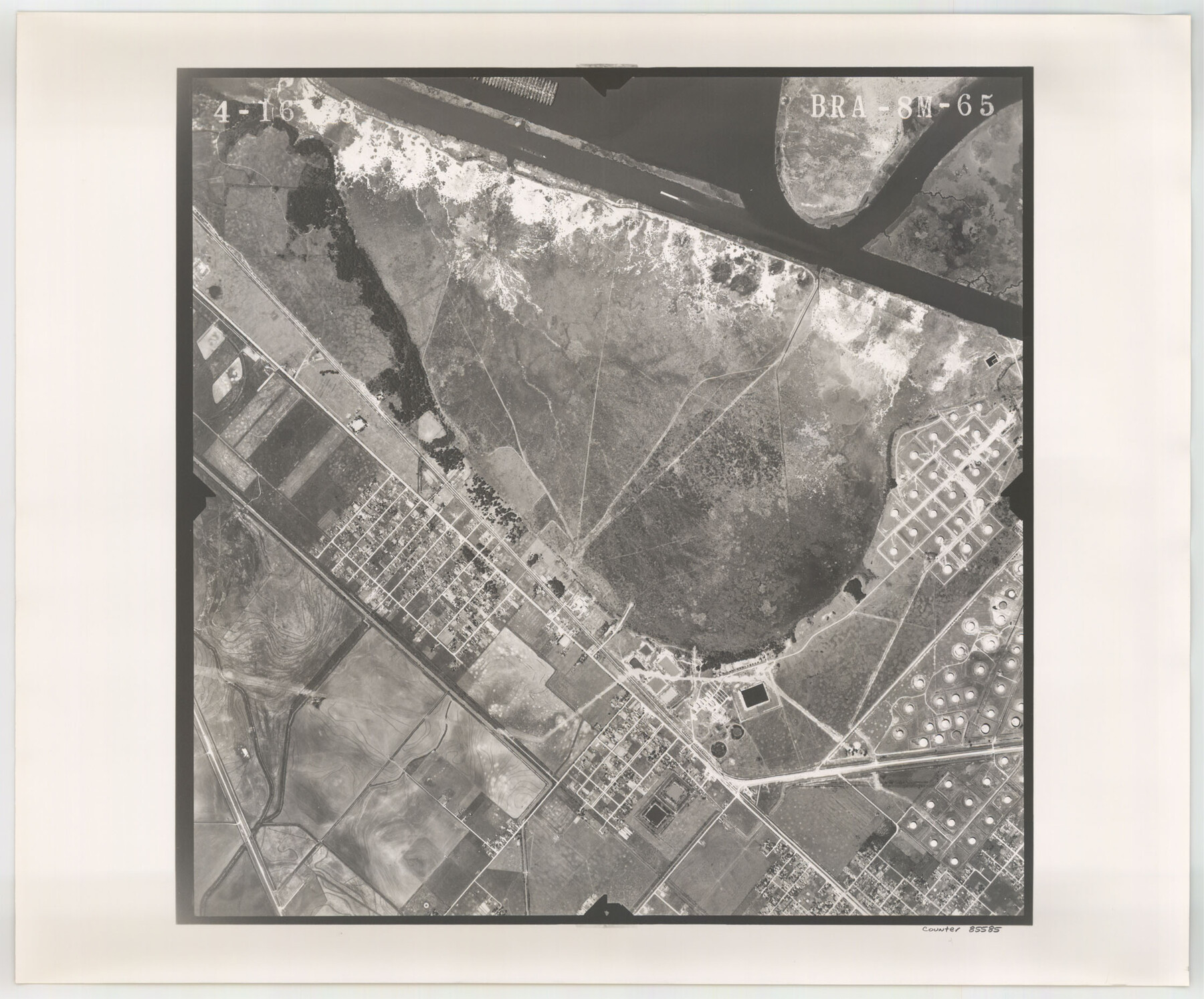
Flight Mission No. BRA-8M, Frame 65, Jefferson County
BRA-8M-65
-
Map/Doc
85585
-
Collection
General Map Collection
-
Object Dates
1953/4/16 (Creation Date)
-
People and Organizations
U. S. Department of Agriculture (Publisher)
-
Counties
Jefferson
-
Subjects
Aerial Photograph
-
Height x Width
18.6 x 22.4 inches
47.2 x 56.9 cm
-
Comments
Flown by Jack Ammann Photogrammetric Engineers of San Antonio, Texas.
Part of: General Map Collection
Dallas County Working Sketch 1

Print $20.00
- Digital $50.00
Dallas County Working Sketch 1
Size 41.4 x 28.3 inches
Map/Doc 68567
Anderson County

Print $40.00
- Digital $50.00
Anderson County
1942
Size 54.2 x 47.3 inches
Map/Doc 66701
[Sketch for Mineral Application 26543 - Sabine River, D. H. Sanford]
![65678, [Sketch for Mineral Application 26543 - Sabine River, D. H. Sanford], General Map Collection](https://historictexasmaps.com/wmedia_w700/maps/65678.tif.jpg)
Print $40.00
- Digital $50.00
[Sketch for Mineral Application 26543 - Sabine River, D. H. Sanford]
1931
Size 73.0 x 30.3 inches
Map/Doc 65678
Hutchinson County Working Sketch 16

Print $20.00
- Digital $50.00
Hutchinson County Working Sketch 16
1953
Size 23.0 x 36.3 inches
Map/Doc 66374
Ward County Rolled Sketch 22

Print $40.00
- Digital $50.00
Ward County Rolled Sketch 22
1873
Size 69.2 x 18.0 inches
Map/Doc 10110
Galveston County Sketch File 34

Print $20.00
- Digital $50.00
Galveston County Sketch File 34
1934
Size 11.5 x 20.1 inches
Map/Doc 11536
Jefferson County Working Sketch 31

Print $20.00
- Digital $50.00
Jefferson County Working Sketch 31
1982
Size 21.3 x 27.6 inches
Map/Doc 66575
Anderson County

Print $40.00
- Digital $50.00
Anderson County
1942
Size 52.9 x 47.9 inches
Map/Doc 66702
La Salle County Sketch File 10

Print $4.00
- Digital $50.00
La Salle County Sketch File 10
1877
Size 9.0 x 7.0 inches
Map/Doc 42997
Coryell County Working Sketch 14

Print $20.00
- Digital $50.00
Coryell County Working Sketch 14
1950
Size 19.4 x 17.5 inches
Map/Doc 68221
Webb County Working Sketch 39

Print $20.00
- Digital $50.00
Webb County Working Sketch 39
1941
Size 22.9 x 17.2 inches
Map/Doc 72404
Stephens County Working Sketch 17

Print $20.00
- Digital $50.00
Stephens County Working Sketch 17
1968
Size 22.7 x 29.1 inches
Map/Doc 63960
You may also like

Live Oak County Rolled Sketch 9

Print $20.00
- Digital $50.00
Live Oak County Rolled Sketch 9
1982
Size 25.6 x 23.3 inches
Map/Doc 6636
United States Great Lakes and adjacent waterways

Print $20.00
- Digital $50.00
United States Great Lakes and adjacent waterways
Size 20.8 x 42.2 inches
Map/Doc 76121
Jasper County Rolled Sketch 8

Print $20.00
- Digital $50.00
Jasper County Rolled Sketch 8
Size 17.8 x 12.0 inches
Map/Doc 6358
Baylor County Sketch File Z1

Print $12.00
- Digital $50.00
Baylor County Sketch File Z1
1901
Size 8.8 x 7.2 inches
Map/Doc 14104
Henderson County Working Sketch 20

Print $20.00
- Digital $50.00
Henderson County Working Sketch 20
1947
Size 31.6 x 18.9 inches
Map/Doc 66153
Culberson County Rolled Sketch 31A

Print $20.00
- Digital $50.00
Culberson County Rolled Sketch 31A
Size 43.4 x 35.6 inches
Map/Doc 8748
Houston County Sketch File 23

Print $6.00
- Digital $50.00
Houston County Sketch File 23
1852
Size 6.5 x 5.2 inches
Map/Doc 26793
Flight Mission No. DQN-2K, Frame 6, Calhoun County

Print $20.00
- Digital $50.00
Flight Mission No. DQN-2K, Frame 6, Calhoun County
1953
Size 18.4 x 22.2 inches
Map/Doc 84223
Orange County Working Sketch 13

Print $20.00
- Digital $50.00
Orange County Working Sketch 13
1922
Size 12.9 x 15.5 inches
Map/Doc 71345
Prison Property, Walker County

Print $20.00
- Digital $50.00
Prison Property, Walker County
Size 16.3 x 15.9 inches
Map/Doc 94280
Liberty County Sketch File 43

Print $4.00
- Digital $50.00
Liberty County Sketch File 43
1863
Size 13.6 x 8.5 inches
Map/Doc 30000