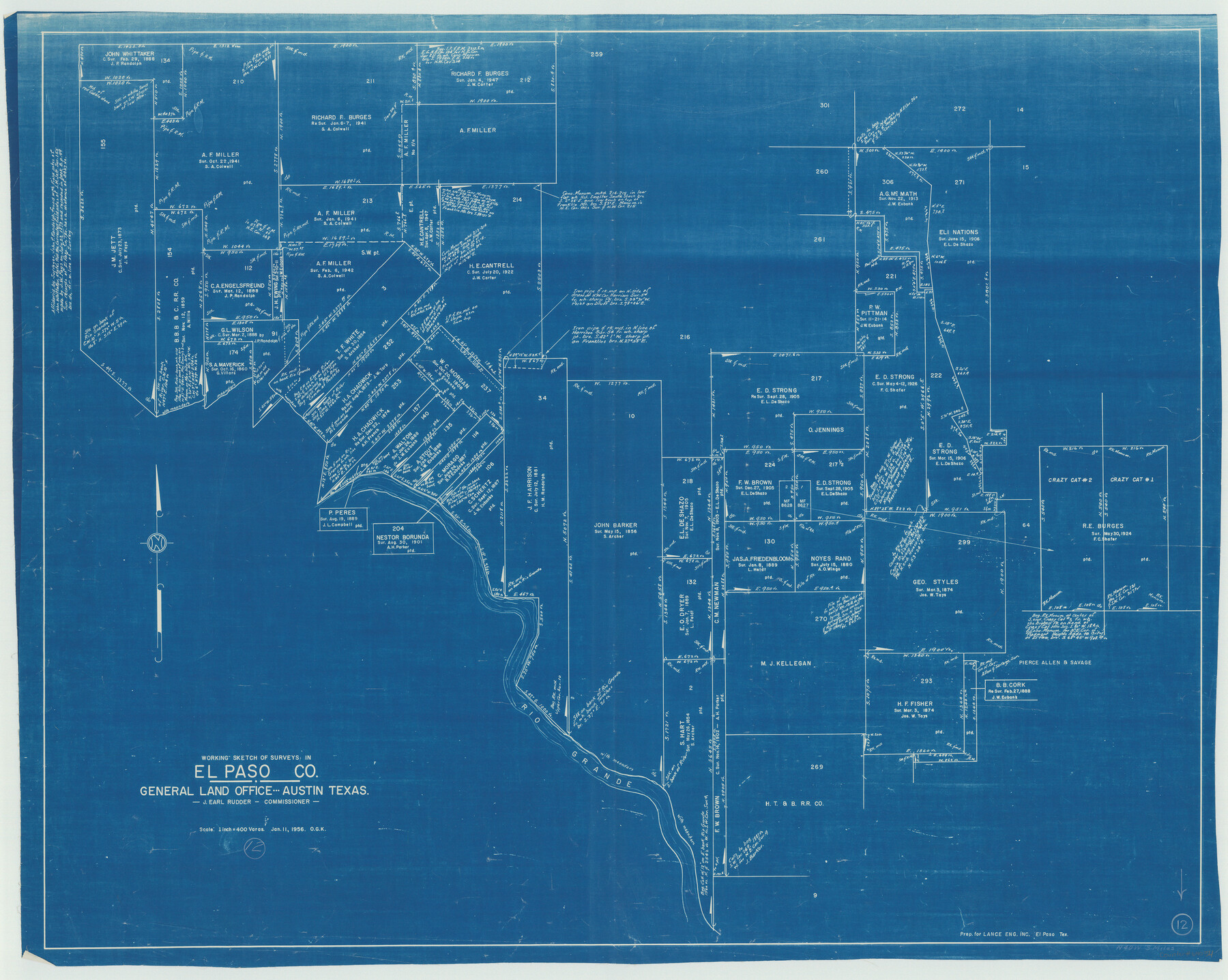
El Paso County Working Sketch 12
-
Map/Doc
69034
-
Collection
General Map Collection
-
Object Dates
1/11/1956 (Creation Date)
-
People and Organizations
Otto G. Kurio (Draftsman)
-
Counties
El Paso
-
Subjects
Surveying Working Sketch
-
Height x Width
33.0 x 41.4 inches
83.8 x 105.2 cm
-
Scale
1" = 400 varas
Part of: General Map Collection
Limestone County Working Sketch 24

Print $20.00
- Digital $50.00
Limestone County Working Sketch 24
1980
Size 28.9 x 31.6 inches
Map/Doc 70574
San Patricio County Rolled Sketch 55

Print $20.00
- Digital $50.00
San Patricio County Rolled Sketch 55
1999
Size 25.1 x 36.7 inches
Map/Doc 7741
Van Zandt County Sketch File 29a

Print $4.00
- Digital $50.00
Van Zandt County Sketch File 29a
1859
Size 14.2 x 6.6 inches
Map/Doc 39455
Matagorda County Sketch File 37

Print $4.00
- Digital $50.00
Matagorda County Sketch File 37
Size 11.3 x 8.8 inches
Map/Doc 30830
Dallas County Boundary File 5a

Print $4.00
- Digital $50.00
Dallas County Boundary File 5a
Size 4.9 x 8.6 inches
Map/Doc 52182
Chambers County Sketch File 11

Print $40.00
- Digital $50.00
Chambers County Sketch File 11
Size 13.7 x 12.6 inches
Map/Doc 17554
[Surveys along the Neches River in Jasper District]
![69733, [Surveys along the Neches River in Jasper District], General Map Collection](https://historictexasmaps.com/wmedia_w700/maps/69733.tif.jpg)
Print $2.00
- Digital $50.00
[Surveys along the Neches River in Jasper District]
1847
Size 9.2 x 6.8 inches
Map/Doc 69733
Frio County Working Sketch 20

Print $20.00
- Digital $50.00
Frio County Working Sketch 20
1985
Size 36.3 x 36.0 inches
Map/Doc 69294
Brazoria County Sketch File 4

Print $4.00
- Digital $50.00
Brazoria County Sketch File 4
1861
Size 7.9 x 9.5 inches
Map/Doc 14927
Knox County Sketch File 9

Print $4.00
- Digital $50.00
Knox County Sketch File 9
1889
Size 11.1 x 8.8 inches
Map/Doc 29221
Refugio County Working Sketch 2

Print $20.00
- Digital $50.00
Refugio County Working Sketch 2
1927
Size 17.6 x 19.4 inches
Map/Doc 63511
St. Louis, Brownsville & Mexico Railway Location Map from Mile 120 to Rio Grande
Print $40.00
- Digital $50.00
St. Louis, Brownsville & Mexico Railway Location Map from Mile 120 to Rio Grande
1905
Size 20.2 x 61.4 inches
Map/Doc 64169
You may also like
Morley's Map of New Mexico compiled from the latest government surveys and other reliable sources

Print $20.00
- Digital $50.00
Morley's Map of New Mexico compiled from the latest government surveys and other reliable sources
1873
Size 26.2 x 28.0 inches
Map/Doc 94052
Hopkins County Sketch File 17

Print $6.00
- Digital $50.00
Hopkins County Sketch File 17
1870
Size 7.8 x 8.0 inches
Map/Doc 26720
Flight Mission No. DQN-1K, Frame 44, Calhoun County

Print $20.00
- Digital $50.00
Flight Mission No. DQN-1K, Frame 44, Calhoun County
1953
Size 18.6 x 22.3 inches
Map/Doc 84144
[Block 3 on East side of County]
![90606, [Block 3 on East side of County], Twichell Survey Records](https://historictexasmaps.com/wmedia_w700/maps/90606-1.tif.jpg)
Print $20.00
- Digital $50.00
[Block 3 on East side of County]
Size 16.9 x 19.8 inches
Map/Doc 90606
Sheet 1 copied from Peck Book 6 [Strip Map showing T. & P. connecting lines]
![93169, Sheet 1 copied from Peck Book 6 [Strip Map showing T. & P. connecting lines], Twichell Survey Records](https://historictexasmaps.com/wmedia_w700/maps/93169-1.tif.jpg)
Print $40.00
- Digital $50.00
Sheet 1 copied from Peck Book 6 [Strip Map showing T. & P. connecting lines]
1909
Size 6.8 x 83.1 inches
Map/Doc 93169
Bandera County Working Sketch 16a

Print $20.00
- Digital $50.00
Bandera County Working Sketch 16a
1941
Size 12.8 x 22.1 inches
Map/Doc 67609
Tom Green County Sketch File 83

Print $20.00
- Digital $50.00
Tom Green County Sketch File 83
1889
Size 20.5 x 22.2 inches
Map/Doc 12455
Crockett County Sketch File 78

Print $20.00
- Digital $50.00
Crockett County Sketch File 78
1931
Size 29.4 x 19.1 inches
Map/Doc 11235
Williamson County

Print $20.00
- Digital $50.00
Williamson County
1919
Size 22.5 x 29.8 inches
Map/Doc 4643
[Drawings of individual counties for Pressler and Langermann's 1879 Map of Texas]
![[Drawings of individual counties for Pressler and Langermann's 1879 Map of Texas]](https://historictexasmaps.com/wmedia_w700/maps/4865.tif.jpg)
Print $20.00
- Digital $50.00
[Drawings of individual counties for Pressler and Langermann's 1879 Map of Texas]
1878
Size 27.3 x 38.1 inches
Map/Doc 4865
Stonewall County Sketch File 28

Print $14.00
- Digital $50.00
Stonewall County Sketch File 28
1970
Size 14.3 x 8.9 inches
Map/Doc 37300
[Sketch of PSL Blocks A20, A35, A44, A45]
![89739, [Sketch of PSL Blocks A20, A35, A44, A45], Twichell Survey Records](https://historictexasmaps.com/wmedia_w700/maps/89739-1.tif.jpg)
Print $40.00
- Digital $50.00
[Sketch of PSL Blocks A20, A35, A44, A45]
Size 22.7 x 66.9 inches
Map/Doc 89739