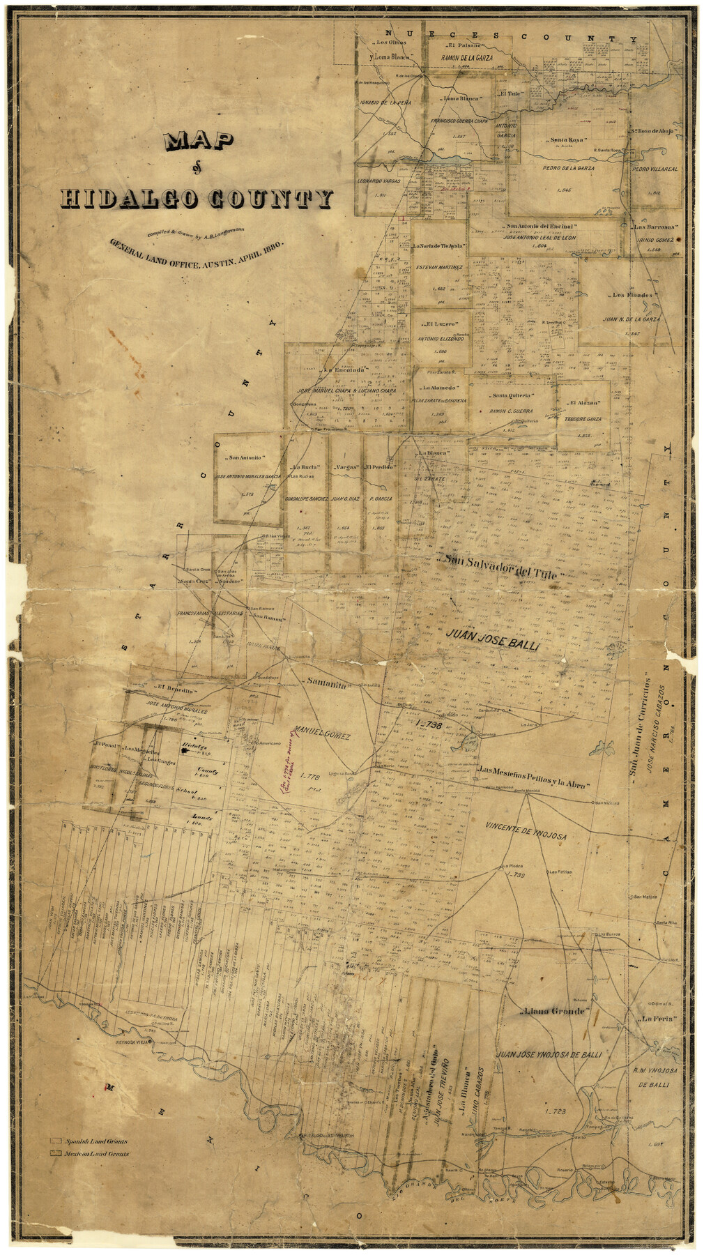
Map of Hidalgo County
-
Map/Doc
3667
-
Collection
General Map Collection
-
Object Dates
4/1880 (Creation Date)
-
People and Organizations
A.B. Langermann (Draftsman)
-
Counties
Hidalgo
-
Subjects
County
-
Height x Width
45.3 x 25.1 inches
115.1 x 63.8 cm
-
Comments
Conservation funded in 2001 with donation from Frost Bank.
-
Features
Rancho San Nicolas
Rancho Los Burros
Rancho Santa Rita
Rancho San Matias
Rancho Las Petitas
Rancho Retama
Rancho Matamoros
Las Cuevas Road
Las Cuevas to La Jara
Rancho La Piedra
Rancho Valla Hermosa
Ranco Santa Monica
Road to las Chiquitas
Rancho Laguna Seca
La Pintoballo
R[anch]o Americano
Rancho La Noria
Rancho La Jara
Austin Road
Austin to El Junco Road
Rancho Guadalupe
Rancho Santanita
Rancho EL Rucio
Cardenaña
Ojo de Agua River
Santa Maria
Rancho Esterito
Rancho Vieja
Rancho Relampargo
Rancho Rosario
Rancho Agua Negre
Rancho Reyes
Rancho Ballie
R[anch]o Blanco
Rancho Naranjado
Rancho Tenajo
Magote San Juan
Ranchito
Rancho Salto
A[rroyo] Colorado
Rancho de Cabasos
Rancho Tampaguas
Rancho Lomitas
Rancho Ebanita
Rancho Colimal
Rancho Penitas
R[ancho] Habana
Rancho Las Cuevas
Lago Tusujal
Noria Salada
Road to las Chiquitas
Purgatorrio
Lago San Juan
Lago Sal Vieja
Lago Sal del Rey
Lago Pintobello
Road to Nopalera
Road to San Colorada
Road to Rio Grande City
El Junco Road
Charco del Pato
Arroyo de las Vacas
Lago Cuates
Lago Suiz
Salt Lake
Laguna Salada
Lago de la Jarita
Lago Tusquita
San Antonio Creek
Los Olmos Creek
Paisano Creek
Palo Blanco Creek
Quiteria Station
Rancho La Jara
Costales
Rancho Juanita
San Jose
Road to Yopalera
San Ramon
Rancho San Jose de Arriba
[Road to] San Colorado
Rancho las Viejas
Arroyo de las Vacas
Las Rucias Rancho
Cibolo Creek
Rancho Gonzalena
Gonzalena [Ranch]
Rancho Tepeguaje
Laguna Sand
Rio Grande del Norte
Edinburgh
Hidalgo
Reynosa Vieja
Sardines Lakes
Cano Lake
Alto Verde
Part of: General Map Collection
Hill County Sketch File 8

Print $4.00
- Digital $50.00
Hill County Sketch File 8
1859
Size 10.1 x 8.2 inches
Map/Doc 26472
Navarro County Sketch File 12

Print $4.00
- Digital $50.00
Navarro County Sketch File 12
Size 7.0 x 7.0 inches
Map/Doc 32322
Upton County Sketch File 36

Print $14.00
- Digital $50.00
Upton County Sketch File 36
1952
Size 11.3 x 8.8 inches
Map/Doc 38893
Delta County Working Sketch Graphic Index

Print $20.00
- Digital $50.00
Delta County Working Sketch Graphic Index
1942
Size 25.3 x 39.2 inches
Map/Doc 76520
[Surveys in the Bexar District along Borrego Creek prepared by the Deputy Surveyor]
![96, [Surveys in the Bexar District along Borrego Creek prepared by the Deputy Surveyor], General Map Collection](https://historictexasmaps.com/wmedia_w700/maps/96.tif.jpg)
Print $2.00
- Digital $50.00
[Surveys in the Bexar District along Borrego Creek prepared by the Deputy Surveyor]
1847
Size 7.7 x 7.2 inches
Map/Doc 96
McLennan County Working Sketch 3

Print $20.00
- Digital $50.00
McLennan County Working Sketch 3
1941
Size 18.0 x 17.9 inches
Map/Doc 70696
Menard County Boundary File 13

Print $32.00
- Digital $50.00
Menard County Boundary File 13
Size 8.9 x 9.4 inches
Map/Doc 57121
[Surveyor's certificate by James Howlet, District Surveyor]
![318, [Surveyor's certificate by James Howlet, District Surveyor], General Map Collection](https://historictexasmaps.com/wmedia_w700/maps/318.tif.jpg)
Print $2.00
- Digital $50.00
[Surveyor's certificate by James Howlet, District Surveyor]
Size 6.1 x 8.0 inches
Map/Doc 318
McMullen County Working Sketch 50

Print $20.00
- Digital $50.00
McMullen County Working Sketch 50
1983
Size 18.4 x 18.0 inches
Map/Doc 70751
Part of Matagorda Bay & Peninsula, Texas

Print $40.00
- Digital $50.00
Part of Matagorda Bay & Peninsula, Texas
1856
Size 31.8 x 51.4 inches
Map/Doc 69978
Brewster County Working Sketch 7

Print $20.00
- Digital $50.00
Brewster County Working Sketch 7
1909
Size 39.9 x 17.1 inches
Map/Doc 67540

You may also like
San Patricio County Working Sketch 12

Print $40.00
- Digital $50.00
San Patricio County Working Sketch 12
Size 51.4 x 40.7 inches
Map/Doc 63774
Shelby County Working Sketch 18

Print $20.00
- Digital $50.00
Shelby County Working Sketch 18
1957
Size 20.7 x 27.4 inches
Map/Doc 63871
Hale County Sketch File 5-5a

Print $30.00
- Digital $50.00
Hale County Sketch File 5-5a
1891
Size 17.7 x 38.3 inches
Map/Doc 10467
United States - Gulf Coast - Padre I. and Laguna Madre Lat. 27° 12' to Lat. 26° 33' Texas

Print $20.00
- Digital $50.00
United States - Gulf Coast - Padre I. and Laguna Madre Lat. 27° 12' to Lat. 26° 33' Texas
1913
Size 26.9 x 18.2 inches
Map/Doc 72820
Montague County Sketch File 9

Print $18.00
- Digital $50.00
Montague County Sketch File 9
1872
Size 12.6 x 11.7 inches
Map/Doc 31724
Nueces County Rolled Sketch 27A

Print $40.00
- Digital $50.00
Nueces County Rolled Sketch 27A
1946
Size 11.6 x 52.4 inches
Map/Doc 76042
The Republic County of Brazoria. May 15, 1838

Print $20.00
The Republic County of Brazoria. May 15, 1838
2020
Size 14.7 x 21.8 inches
Map/Doc 96112
Spence Addition Owned by L.N. Goldbeck and Herman Pressler - A Subdivision of Outlot 43, Division "O"

Print $20.00
- Digital $50.00
Spence Addition Owned by L.N. Goldbeck and Herman Pressler - A Subdivision of Outlot 43, Division "O"
1913
Size 15.5 x 12.8 inches
Map/Doc 83424
San Saba County Sketch File 7

Print $22.00
- Digital $50.00
San Saba County Sketch File 7
1883
Size 8.6 x 7.8 inches
Map/Doc 36417
Houston including Bellaire, Bunker Hill, Galena Park, Hedwig, Hilshire, Hunters Creek, Jacinto City, Jersey Village, Missouri City, Pasadena, Piney Point, South Houston, Spring Valley, West University Place and adjoining communities [Recto]
![94179, Houston including Bellaire, Bunker Hill, Galena Park, Hedwig, Hilshire, Hunters Creek, Jacinto City, Jersey Village, Missouri City, Pasadena, Piney Point, South Houston, Spring Valley, West University Place and adjoining communities [Recto], General Map Collection](https://historictexasmaps.com/wmedia_w700/maps/94179.tif.jpg)
Houston including Bellaire, Bunker Hill, Galena Park, Hedwig, Hilshire, Hunters Creek, Jacinto City, Jersey Village, Missouri City, Pasadena, Piney Point, South Houston, Spring Valley, West University Place and adjoining communities [Recto]
Size 27.1 x 42.6 inches
Map/Doc 94179
Flight Mission No. CRK-5P, Frame 153, Refugio County

Print $20.00
- Digital $50.00
Flight Mission No. CRK-5P, Frame 153, Refugio County
1956
Size 18.4 x 22.3 inches
Map/Doc 86934
Briscoe County Sketch File 2

Print $40.00
- Digital $50.00
Briscoe County Sketch File 2
1880
Size 18.3 x 15.4 inches
Map/Doc 10991