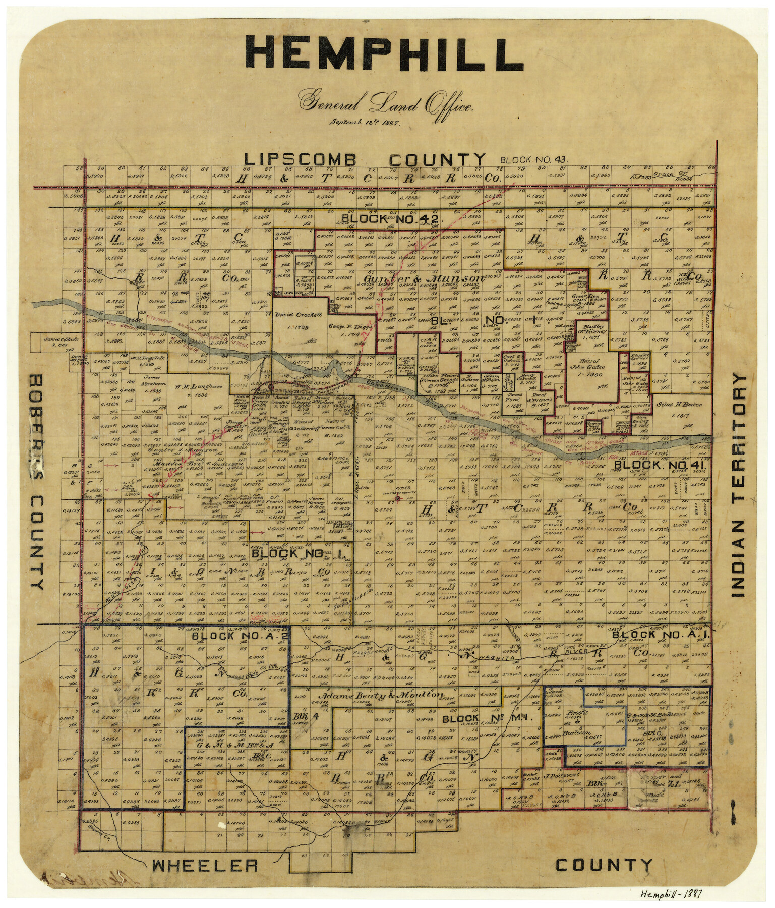
Hemphill
-
Map/Doc
3662
-
Collection
General Map Collection
-
Object Dates
1887/9/12 (Creation Date)
-
People and Organizations
Texas General Land Office (Publisher)
-
Counties
Hemphill
-
Subjects
County
-
Height x Width
20.4 x 17.4 inches
51.8 x 44.2 cm
-
Features
SKR
Canadian
Canadian River
Washita River
Grace Creek
Red Deer Creek
White Creek
Alexander's Creek
Browns Creek
Part of: General Map Collection
Motley County Sketch File 5 (N)

Print $8.00
- Digital $50.00
Motley County Sketch File 5 (N)
Size 12.6 x 8.3 inches
Map/Doc 32000
San Jacinto County Working Sketch 39

Print $20.00
- Digital $50.00
San Jacinto County Working Sketch 39
1971
Size 41.3 x 44.2 inches
Map/Doc 63752
Montague County Working Sketch 40

Print $20.00
- Digital $50.00
Montague County Working Sketch 40
1995
Size 20.6 x 17.5 inches
Map/Doc 71106
Van Zandt County Working Sketch 11

Print $20.00
- Digital $50.00
Van Zandt County Working Sketch 11
1982
Size 15.2 x 9.3 inches
Map/Doc 72261

Starr County Working Sketch 27

Print $20.00
- Digital $50.00
Starr County Working Sketch 27
1994
Size 29.6 x 30.3 inches
Map/Doc 63943
Kaufman County Sketch File 3

Print $20.00
- Digital $50.00
Kaufman County Sketch File 3
1857
Size 25.3 x 18.7 inches
Map/Doc 4856
Zapata County

Print $40.00
- Digital $50.00
Zapata County
1901
Size 53.1 x 38.0 inches
Map/Doc 63143
Hunt County Sketch File 17

Print $8.00
- Digital $50.00
Hunt County Sketch File 17
1861
Size 10.6 x 8.2 inches
Map/Doc 27114
Jefferson County Working Sketch 24

Print $20.00
- Digital $50.00
Jefferson County Working Sketch 24
1977
Size 28.4 x 44.5 inches
Map/Doc 66567
Rockwall County Boundary File 52a

Print $22.00
- Digital $50.00
Rockwall County Boundary File 52a
Size 12.9 x 8.3 inches
Map/Doc 58461
Rains County Boundary File 2

Print $4.00
- Digital $50.00
Rains County Boundary File 2
Size 8.2 x 5.8 inches
Map/Doc 58092
You may also like
Cameron County Rolled Sketch 25

Print $20.00
- Digital $50.00
Cameron County Rolled Sketch 25
1977
Size 24.8 x 36.8 inches
Map/Doc 5792
Pecos County Rolled Sketch DK3

Print $20.00
- Digital $50.00
Pecos County Rolled Sketch DK3
1938
Size 35.3 x 42.3 inches
Map/Doc 9715
Van Zandt County Sketch File 16 1/2

Print $4.00
- Digital $50.00
Van Zandt County Sketch File 16 1/2
1858
Size 11.0 x 7.8 inches
Map/Doc 39414
Flight Mission No. DCL-4C, Frame 64, Kenedy County

Print $20.00
- Digital $50.00
Flight Mission No. DCL-4C, Frame 64, Kenedy County
1943
Size 18.6 x 22.4 inches
Map/Doc 85809
Edwards County Rolled Sketch JFW1

Print $53.00
- Digital $50.00
Edwards County Rolled Sketch JFW1
1935
Size 10.3 x 15.5 inches
Map/Doc 44398
[Blocks C4, SI, and JK]
![90778, [Blocks C4, SI, and JK], Twichell Survey Records](https://historictexasmaps.com/wmedia_w700/maps/90778-1.tif.jpg)
Print $20.00
- Digital $50.00
[Blocks C4, SI, and JK]
Size 15.0 x 13.3 inches
Map/Doc 90778
Pecos County Working Sketch 138

Print $20.00
- Digital $50.00
Pecos County Working Sketch 138
1981
Size 23.2 x 26.3 inches
Map/Doc 71612
Castro County Sketch File 4m

Print $4.00
- Digital $50.00
Castro County Sketch File 4m
Size 13.6 x 8.6 inches
Map/Doc 17489
San Augustine County Working Sketch 24

Print $20.00
- Digital $50.00
San Augustine County Working Sketch 24
1975
Size 27.8 x 39.1 inches
Map/Doc 63712
Harrison County Sketch File 23

Print $125.00
- Digital $50.00
Harrison County Sketch File 23
Size 10.6 x 12.2 inches
Map/Doc 26061
Borden County Rolled Sketch 7

Print $20.00
- Digital $50.00
Borden County Rolled Sketch 7
Size 16.9 x 18.5 inches
Map/Doc 5157
General Highway Map, Potter County, Texas

Print $20.00
General Highway Map, Potter County, Texas
1940
Size 24.6 x 18.3 inches
Map/Doc 79220