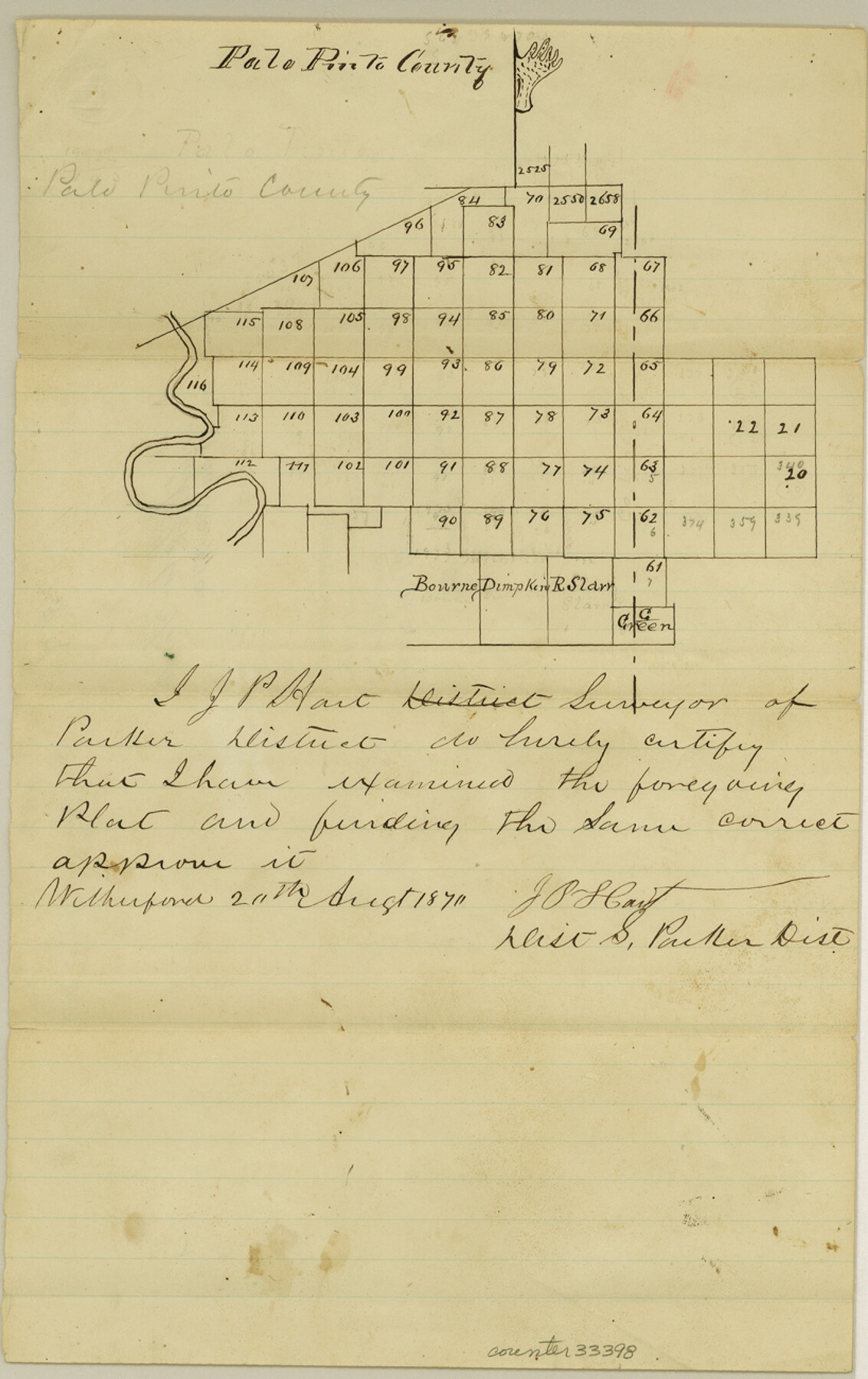
Palo Pinto County Sketch File 7
[Sketch northeast of Palo Pinto in Block A]
-
Map/Doc
33398
-
Collection
General Map Collection
-
Object Dates
8/20/1870 (Creation Date)
-
People and Organizations
J.P. Hart (Surveyor/Engineer)
-
Counties
Palo Pinto Parker
-
Subjects
Surveying Sketch File
-
Height x Width
13.0 x 8.2 inches
33.0 x 20.8 cm
-
Medium
paper, manuscript
Part of: General Map Collection
Jefferson County Rolled Sketch 4

Print $40.00
- Digital $50.00
Jefferson County Rolled Sketch 4
Size 36.7 x 65.3 inches
Map/Doc 9269
Flight Mission No. BQR-12K, Frame 44, Brazoria County

Print $20.00
- Digital $50.00
Flight Mission No. BQR-12K, Frame 44, Brazoria County
1952
Size 18.8 x 22.4 inches
Map/Doc 84059
Fisher County Sketch File A

Print $20.00
- Digital $50.00
Fisher County Sketch File A
1901
Size 33.1 x 22.8 inches
Map/Doc 11482
Duval County Rolled Sketch 46

Print $20.00
- Digital $50.00
Duval County Rolled Sketch 46
1985
Size 24.9 x 36.1 inches
Map/Doc 5761
Freestone County Working Sketch 30

Print $20.00
- Digital $50.00
Freestone County Working Sketch 30
Size 29.5 x 37.2 inches
Map/Doc 69272
Newton County Rolled Sketch 6

Print $20.00
- Digital $50.00
Newton County Rolled Sketch 6
Size 24.9 x 45.7 inches
Map/Doc 6842
Austin County Sketch File EF

Print $40.00
- Digital $50.00
Austin County Sketch File EF
1895
Size 15.1 x 17.0 inches
Map/Doc 10879
Jefferson County Sketch File 26a

Print $20.00
- Digital $50.00
Jefferson County Sketch File 26a
Size 19.5 x 11.6 inches
Map/Doc 11872
Navigation Maps of Gulf Intracoastal Waterway, Port Arthur to Brownsville, Texas

Print $4.00
- Digital $50.00
Navigation Maps of Gulf Intracoastal Waterway, Port Arthur to Brownsville, Texas
1951
Size 16.7 x 21.5 inches
Map/Doc 65443
Duval County Boundary File 1a

Print $18.00
- Digital $50.00
Duval County Boundary File 1a
Size 12.8 x 8.4 inches
Map/Doc 52670
McMullen County Rolled Sketch 17

Print $40.00
- Digital $50.00
McMullen County Rolled Sketch 17
1950
Map/Doc 9501

You may also like
Jefferson County Rolled Sketch 33

Print $20.00
- Digital $50.00
Jefferson County Rolled Sketch 33
1956
Size 46.8 x 27.5 inches
Map/Doc 6393
Flight Mission No. DIX-6P, Frame 189, Aransas County

Print $20.00
- Digital $50.00
Flight Mission No. DIX-6P, Frame 189, Aransas County
1956
Size 19.1 x 22.8 inches
Map/Doc 83851
[Hutchinson County, Blocks R, XO, M-22, M-25]
![91152, [Hutchinson County, Blocks R, XO, M-22, M-25], Twichell Survey Records](https://historictexasmaps.com/wmedia_w700/maps/91152-1.tif.jpg)
Print $20.00
- Digital $50.00
[Hutchinson County, Blocks R, XO, M-22, M-25]
Size 28.5 x 25.9 inches
Map/Doc 91152
Blocks 17, 18 & 19, Capitol Syndicate Subdivision of Capitol Land Reservation Leagues of Portions of Leagues Number 16, 6, 7, 8, 9, 11, 12, 13, 14, 17, 18. 19, 20, 21, 22, 38, 39, 40, 41, 42, 43, 44, 45 and 46

Print $40.00
- Digital $50.00
Blocks 17, 18 & 19, Capitol Syndicate Subdivision of Capitol Land Reservation Leagues of Portions of Leagues Number 16, 6, 7, 8, 9, 11, 12, 13, 14, 17, 18. 19, 20, 21, 22, 38, 39, 40, 41, 42, 43, 44, 45 and 46
Size 50.5 x 30.9 inches
Map/Doc 89686
Map of Cooke County

Print $20.00
- Digital $50.00
Map of Cooke County
1857
Size 34.1 x 37.9 inches
Map/Doc 1973
Cherokee County Working Sketch 13

Print $20.00
- Digital $50.00
Cherokee County Working Sketch 13
1957
Size 46.5 x 43.8 inches
Map/Doc 67968
Flight Mission No. BRA-6M, Frame 96, Jefferson County

Print $20.00
- Digital $50.00
Flight Mission No. BRA-6M, Frame 96, Jefferson County
1953
Size 18.5 x 22.3 inches
Map/Doc 85439
Terry County Boundary File 2a

Print $32.00
- Digital $50.00
Terry County Boundary File 2a
Size 11.6 x 8.9 inches
Map/Doc 59209
Hudspeth County Rolled Sketch 61

Print $40.00
- Digital $50.00
Hudspeth County Rolled Sketch 61
1982
Size 71.3 x 45.1 inches
Map/Doc 9626
Anderson County Working Sketch 11

Print $40.00
- Digital $50.00
Anderson County Working Sketch 11
1933
Size 42.8 x 57.9 inches
Map/Doc 67010
Andrews County Working Sketch 3

Print $40.00
- Digital $50.00
Andrews County Working Sketch 3
1953
Size 78.9 x 35.8 inches
Map/Doc 67049
Archer County Rolled Sketch 10

Print $20.00
- Digital $50.00
Archer County Rolled Sketch 10
2012
Size 19.2 x 24.6 inches
Map/Doc 93326