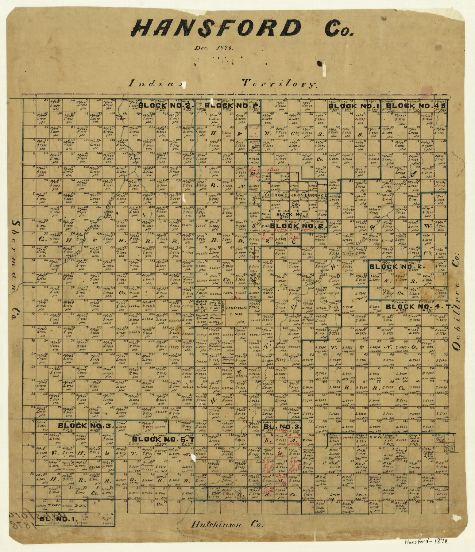
Hansford County
-
Map/Doc
3623
-
Collection
General Map Collection
-
Object Dates
12/1878 (Creation Date)
-
Counties
Hansford
-
Subjects
County
-
Height x Width
19.5 x 17.0 inches
49.5 x 43.2 cm
-
Features
Indian Territory
Paladora Creek
Rabbits [sic] Ear Creek
Part of: General Map Collection
Milam County Working Sketch 2

Print $20.00
- Digital $50.00
Milam County Working Sketch 2
1937
Size 20.2 x 20.5 inches
Map/Doc 71017
Jeff Davis County Texas

Print $20.00
- Digital $50.00
Jeff Davis County Texas
Size 16.1 x 21.1 inches
Map/Doc 4572
Houston County Working Sketch 20

Print $20.00
- Digital $50.00
Houston County Working Sketch 20
1979
Size 26.7 x 24.0 inches
Map/Doc 66250
Fort Bend County Sketch File 11a

Print $34.00
- Digital $50.00
Fort Bend County Sketch File 11a
1888
Size 14.3 x 9.1 inches
Map/Doc 22901
Dallas County

Print $20.00
- Digital $50.00
Dallas County
1942
Size 45.5 x 38.0 inches
Map/Doc 16954
Brazoria County NRC Article 33.136 Location Key Sheet

Print $20.00
- Digital $50.00
Brazoria County NRC Article 33.136 Location Key Sheet
1965
Size 27.0 x 22.0 inches
Map/Doc 77007
[Sketch of expeditions, trails in Jones, Taylor, Shackelford, Callahan, Buchanan/Stephens and Eastland Counties]
![65406, [Sketch of expeditions, trails in Jones, Taylor, Shackelford, Callahan, Buchanan/Stephens and Eastland Counties], General Map Collection](https://historictexasmaps.com/wmedia_w700/maps/65406.tif.jpg)
Print $4.00
- Digital $50.00
[Sketch of expeditions, trails in Jones, Taylor, Shackelford, Callahan, Buchanan/Stephens and Eastland Counties]
1873
Size 10.7 x 18.1 inches
Map/Doc 65406
Flight Mission No. DAH-17M, Frame 30, Orange County

Print $20.00
- Digital $50.00
Flight Mission No. DAH-17M, Frame 30, Orange County
1953
Size 18.7 x 22.5 inches
Map/Doc 86893
Wise County Rolled Sketch 7

Print $20.00
- Digital $50.00
Wise County Rolled Sketch 7
Size 23.9 x 18.4 inches
Map/Doc 8281
Presidio County Rolled Sketch 76

Print $20.00
- Digital $50.00
Presidio County Rolled Sketch 76
Size 24.3 x 36.4 inches
Map/Doc 9777
Harris County Working Sketch 118

Print $20.00
- Digital $50.00
Harris County Working Sketch 118
1984
Size 24.1 x 34.8 inches
Map/Doc 66010
Flight Mission No. BQY-15M, Frame 10, Harris County

Print $20.00
- Digital $50.00
Flight Mission No. BQY-15M, Frame 10, Harris County
1953
Size 18.5 x 22.3 inches
Map/Doc 85308
You may also like
Nueces County Rolled Sketch 55

Print $20.00
- Digital $50.00
Nueces County Rolled Sketch 55
1978
Size 25.7 x 37.5 inches
Map/Doc 6892
Webb County Rolled Sketch 68

Print $43.00
- Digital $50.00
Webb County Rolled Sketch 68
1910
Size 9.6 x 15.1 inches
Map/Doc 49485
Brooks County Rolled Sketch 28

Print $20.00
- Digital $50.00
Brooks County Rolled Sketch 28
1947
Size 28.9 x 32.0 inches
Map/Doc 5346
Traced from Genl. Arista's map captured by the American Army under Genl. Taylor at Resaca de la Palma 9th May '46 and presented to James K. Polk, President U. States

Print $20.00
- Digital $50.00
Traced from Genl. Arista's map captured by the American Army under Genl. Taylor at Resaca de la Palma 9th May '46 and presented to James K. Polk, President U. States
1846
Size 18.2 x 27.3 inches
Map/Doc 73060
Brewster County Rolled Sketch 118

Print $20.00
- Digital $50.00
Brewster County Rolled Sketch 118
1971
Size 25.3 x 37.2 inches
Map/Doc 5295
Frio County Working Sketch Graphic Index

Print $20.00
- Digital $50.00
Frio County Working Sketch Graphic Index
1944
Size 43.0 x 41.4 inches
Map/Doc 76549
Sutton County Sketch File JAC (1)

Print $6.00
- Digital $50.00
Sutton County Sketch File JAC (1)
1937
Size 14.3 x 8.8 inches
Map/Doc 37502
[Surveys along the Leona and Frio Rivers]
![16, [Surveys along the Leona and Frio Rivers], General Map Collection](https://historictexasmaps.com/wmedia_w700/maps/16.tif.jpg)
Print $20.00
- Digital $50.00
[Surveys along the Leona and Frio Rivers]
1841
Size 12.4 x 13.1 inches
Map/Doc 16
Culberson County Sketch File 28

Print $4.00
- Digital $50.00
Culberson County Sketch File 28
1949
Size 14.5 x 9.0 inches
Map/Doc 20280
[Beaumont, Sour Lake and Western Ry. Right of Way and Alignment - Frisco]
![64112, [Beaumont, Sour Lake and Western Ry. Right of Way and Alignment - Frisco], General Map Collection](https://historictexasmaps.com/wmedia_w700/maps/64112.tif.jpg)
Print $20.00
- Digital $50.00
[Beaumont, Sour Lake and Western Ry. Right of Way and Alignment - Frisco]
1910
Size 20.3 x 46.0 inches
Map/Doc 64112
Nueces County Sketch File 16

Print $6.00
- Digital $50.00
Nueces County Sketch File 16
1875
Size 15.5 x 10.7 inches
Map/Doc 32547
Liberty County Working Sketch 78

Print $20.00
- Digital $50.00
Liberty County Working Sketch 78
1981
Size 36.2 x 41.0 inches
Map/Doc 70538