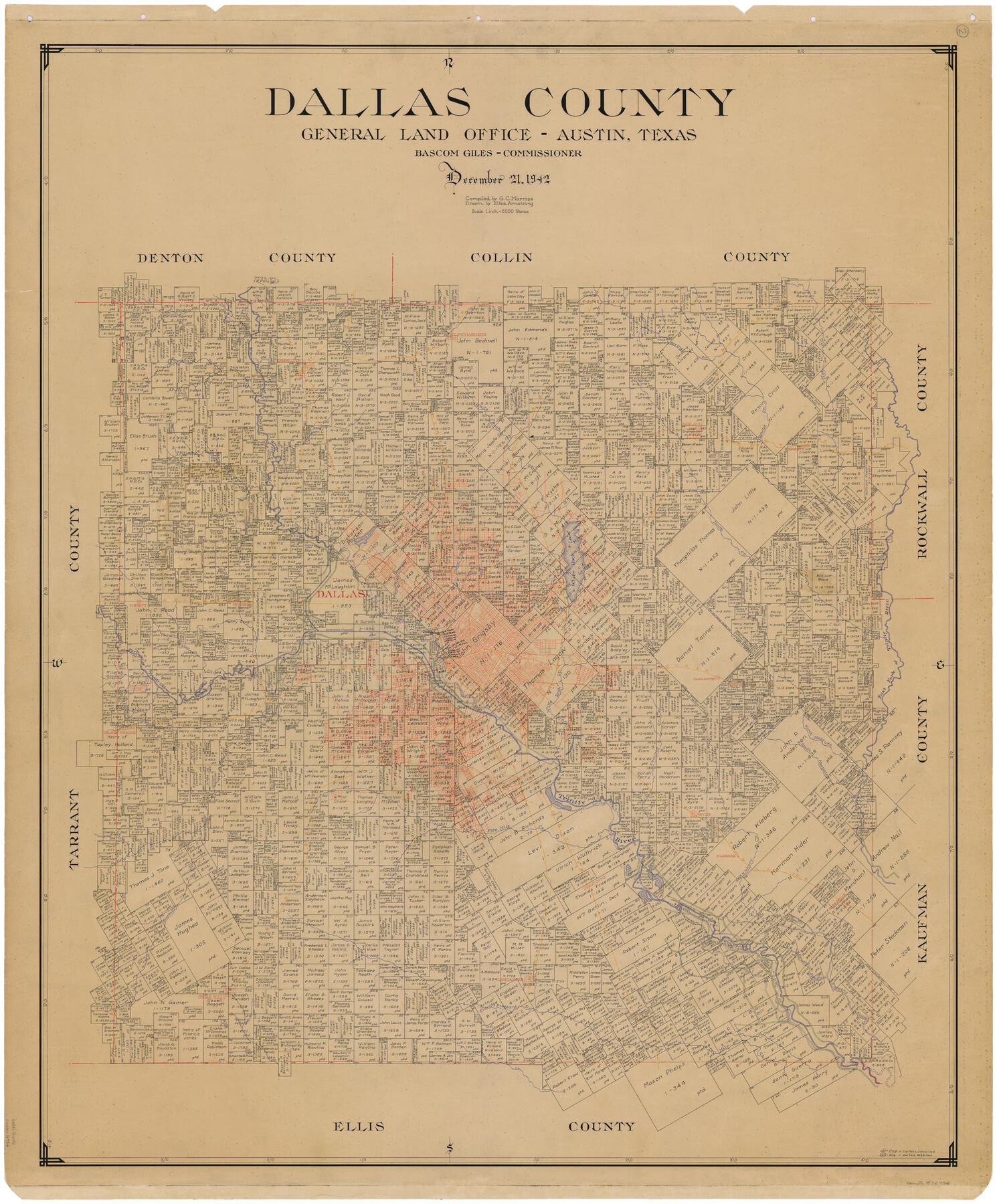
Dallas County
-
Map/Doc
16954
-
Collection
General Map Collection
-
Object Dates
12/21/1942 (Creation Date)
-
People and Organizations
Eltea Armstrong (Draftsman)
Bascom Giles (GLO Commissioner)
G.C. Morriss (Compiler)
-
Counties
Dallas
-
Subjects
County
-
Height x Width
45.5 x 38.0 inches
115.6 x 96.5 cm
-
Comments
Hand lettered.
Note on reverse side: "Compilation completed December 21, 1942. Inking completed April 10, 1943. Tracing completed June 18, 1943. Placed in official use June 19, 1943. Replaced [on sticks] by copy June 20, 1946."
-
Features
Hickory Creek
West Fork of Trinity River
Grand Prairie
Horseshoe Lake
Charleston
Mesquite
North Mesquite Creek
South Mesquite Creek
Prairie Creek
Alum Creek
Fish Creek
Five Mile Creek
Trinity Rod Gun Club Lake
Fin & Feather Club Lake
Rylie
Kleberg
Liggett
T&NO
Seagoville
Brushy Slough Swamp
Dallas Hunting & Fishing Club Lake
Lancaster Club Lake
Hutchins
Lancaster
Mountain Creek
Cedar Hill
Pleasant Run Creek
Ten Mile Creek
Parsons Slough Swamp
Bear Creek
Dallas
H&TC
D&W
SLS
Elm Fork of Trinity River
Grapevine Creek
Hackberry Creek
CRI&G
Carrollton
GC&SF
Richardson
Spring Creek
Mud Creek
MK&T
Rowlett
Rowlet [sic] Creek
Garland
Denton Creek
White Rock Creek
Farmer Creek
Trinity River
Owens Lake
Bachmans Lake
Browning Creek
Duck Creek
East Fork of Trinity River
T&P
Turtle Creek
Mannins Branch of Trinity River
Diversion Channel
Irving
Bear Creek
Part of: General Map Collection
Brazoria County Working Sketch 49a

Print $20.00
- Digital $50.00
Brazoria County Working Sketch 49a
2003
Size 35.0 x 35.0 inches
Map/Doc 78347
Jackson County Working Sketch Graphic Index

Print $20.00
- Digital $50.00
Jackson County Working Sketch Graphic Index
1920
Size 47.0 x 40.3 inches
Map/Doc 76590
Intracoastal Waterway in Texas - Corpus Christi to Point Isabel including Arroyo Colorado to Mo. Pac. R.R. Bridge Near Harlingen

Print $20.00
- Digital $50.00
Intracoastal Waterway in Texas - Corpus Christi to Point Isabel including Arroyo Colorado to Mo. Pac. R.R. Bridge Near Harlingen
1933
Size 28.2 x 41.0 inches
Map/Doc 61846
San Augustine County Sketch File 7

Print $4.00
San Augustine County Sketch File 7
1858
Size 7.0 x 8.2 inches
Map/Doc 35646
Comal County Working Sketch 3

Print $20.00
- Digital $50.00
Comal County Working Sketch 3
1944
Size 31.1 x 27.9 inches
Map/Doc 68169
Pecos County Rolled Sketch 146B

Print $20.00
- Digital $50.00
Pecos County Rolled Sketch 146B
Size 42.3 x 37.8 inches
Map/Doc 9742
Harrison County Sketch File 20

Print $20.00
- Digital $50.00
Harrison County Sketch File 20
1946
Size 26.4 x 21.8 inches
Map/Doc 11693
Fort Bend County Rolled Sketch A

Print $20.00
- Digital $50.00
Fort Bend County Rolled Sketch A
1900
Size 19.8 x 29.7 inches
Map/Doc 5903
Coast Chart No. 210 Aransas Pass and Corpus Christi Bay with the coast to latitude 27° 12' Texas

Print $20.00
- Digital $50.00
Coast Chart No. 210 Aransas Pass and Corpus Christi Bay with the coast to latitude 27° 12' Texas
1887
Size 27.3 x 18.3 inches
Map/Doc 72803
Carson County Sketch File 7

Print $20.00
- Digital $50.00
Carson County Sketch File 7
Size 26.7 x 15.0 inches
Map/Doc 11056
Liberty County Working Sketch 49b

Print $20.00
- Digital $50.00
Liberty County Working Sketch 49b
1955
Size 28.0 x 31.0 inches
Map/Doc 70509
Lavaca County Boundary File 58

Print $20.00
- Digital $50.00
Lavaca County Boundary File 58
Size 8.5 x 7.1 inches
Map/Doc 56259
You may also like
Floyd County Sketch File 9a

Print $4.00
- Digital $50.00
Floyd County Sketch File 9a
1912
Size 14.5 x 8.9 inches
Map/Doc 22699
Flight Mission No. BRE-3P, Frame 35, Nueces County

Print $20.00
- Digital $50.00
Flight Mission No. BRE-3P, Frame 35, Nueces County
1956
Size 18.5 x 21.1 inches
Map/Doc 86813
Tarrant County Sketch File 21

Print $4.00
- Digital $50.00
Tarrant County Sketch File 21
Size 12.5 x 8.4 inches
Map/Doc 37725
McMullen County Sketch File 14

Print $4.00
- Digital $50.00
McMullen County Sketch File 14
1876
Size 10.0 x 8.1 inches
Map/Doc 31361
Flight Mission No. CRE-1R, Frame 191, Jackson County

Print $20.00
- Digital $50.00
Flight Mission No. CRE-1R, Frame 191, Jackson County
1956
Size 18.4 x 22.3 inches
Map/Doc 85345
Nueces County Rolled Sketch 81

Print $278.00
- Digital $50.00
Nueces County Rolled Sketch 81
1982
Size 24.3 x 36.2 inches
Map/Doc 6960
Map of a portion of the City of Galveston, Texas showing proposed location of Sea Wall and Right of Way to be obtained

Print $20.00
- Digital $50.00
Map of a portion of the City of Galveston, Texas showing proposed location of Sea Wall and Right of Way to be obtained
1902
Size 16.5 x 38.5 inches
Map/Doc 73625
Township 9 North Range 14 West, North Western District, Louisiana

Print $20.00
- Digital $50.00
Township 9 North Range 14 West, North Western District, Louisiana
1854
Size 19.5 x 24.6 inches
Map/Doc 65873
[Cotton Belt, St. Louis Southwestern Railway of Texas, Alignment through Smith County]
![64377, [Cotton Belt, St. Louis Southwestern Railway of Texas, Alignment through Smith County], General Map Collection](https://historictexasmaps.com/wmedia_w700/maps/64377.tif.jpg)
Print $20.00
- Digital $50.00
[Cotton Belt, St. Louis Southwestern Railway of Texas, Alignment through Smith County]
1903
Size 21.7 x 30.0 inches
Map/Doc 64377
Gaines County Working Sketch 22

Print $40.00
- Digital $50.00
Gaines County Working Sketch 22
1975
Size 52.5 x 33.9 inches
Map/Doc 69322
Andrews County Sketch File 19

Print $12.00
- Digital $50.00
Andrews County Sketch File 19
Size 14.3 x 8.8 inches
Map/Doc 12912
Kleberg County Rolled Sketch 10-38

Print $20.00
- Digital $50.00
Kleberg County Rolled Sketch 10-38
1952
Size 36.5 x 30.8 inches
Map/Doc 9372