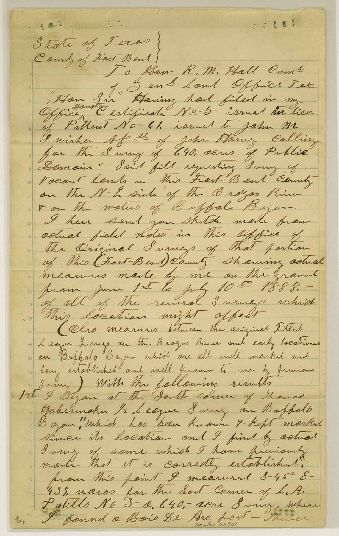
Fort Bend County Sketch File 11a
[Report and sketch of surveys in the northern part of the county]
-
Map/Doc
22901
-
Collection
General Map Collection
-
Object Dates
7/10/1888 (Creation Date)
10/24/1888 (File Date)
6/1/1888 - 7/10/1888 (Survey Date)
-
People and Organizations
S.M. Farr (Surveyor/Engineer)
-
Counties
Fort Bend
-
Subjects
Surveying Sketch File
-
Height x Width
14.3 x 9.1 inches
36.3 x 23.1 cm
-
Medium
paper, manuscript
-
Features
Brazos River
Buffalo Bayou
Little Prong of Buffalo Bayou
Part of: General Map Collection
Cherokee County Sketch File 16

Print $44.00
- Digital $50.00
Cherokee County Sketch File 16
1862
Size 10.0 x 8.0 inches
Map/Doc 18152
Kendall County Working Sketch 24

Print $20.00
- Digital $50.00
Kendall County Working Sketch 24
1977
Size 27.6 x 26.1 inches
Map/Doc 66696
Pecos County Working Sketch 72

Print $40.00
- Digital $50.00
Pecos County Working Sketch 72
1957
Size 106.0 x 43.6 inches
Map/Doc 71544
Rand McNally Standard Map of Texas

Rand McNally Standard Map of Texas
1930
Size 34.6 x 28.0 inches
Map/Doc 2147
Presidio County Rolled Sketch 61

Print $20.00
- Digital $50.00
Presidio County Rolled Sketch 61
1914
Size 16.0 x 19.7 inches
Map/Doc 7353
[Bastrop District]
![83005, [Bastrop District], General Map Collection](https://historictexasmaps.com/wmedia_w700/maps/83005.tif.jpg)
Print $40.00
- Digital $50.00
[Bastrop District]
1895
Size 37.4 x 51.9 inches
Map/Doc 83005
Nacogdoches County Working Sketch Graphic Index

Print $20.00
- Digital $50.00
Nacogdoches County Working Sketch Graphic Index
1950
Size 46.9 x 41.3 inches
Map/Doc 76651
Coke County Boundary File 1

Print $50.00
- Digital $50.00
Coke County Boundary File 1
Size 8.9 x 4.0 inches
Map/Doc 51570


Concho County Rolled Sketch 5

Print $20.00
- Digital $50.00
Concho County Rolled Sketch 5
1950
Size 41.9 x 27.6 inches
Map/Doc 5545
Terrell County Working Sketch 33

Print $20.00
- Digital $50.00
Terrell County Working Sketch 33
1945
Size 16.1 x 31.6 inches
Map/Doc 62125
You may also like

Martha's Vineyard to Block Island Including Western Approach to Cape Cod Canal

Print $20.00
- Digital $50.00
Martha's Vineyard to Block Island Including Western Approach to Cape Cod Canal
1963
Size 37.5 x 45.7 inches
Map/Doc 73554
Flight Mission No. DCL-7C, Frame 124, Kenedy County

Print $20.00
- Digital $50.00
Flight Mission No. DCL-7C, Frame 124, Kenedy County
1943
Size 18.6 x 22.2 inches
Map/Doc 86089
Kleberg County Rolled Sketch 5

Print $20.00
- Digital $50.00
Kleberg County Rolled Sketch 5
Size 27.8 x 21.8 inches
Map/Doc 6548
Pecos County Sketch showing location of oil wells within 1/2 mile radius of the south 8 acres of the Bob Reid survey

Print $20.00
- Digital $50.00
Pecos County Sketch showing location of oil wells within 1/2 mile radius of the south 8 acres of the Bob Reid survey
Size 18.4 x 16.5 inches
Map/Doc 91639
Myrick Farm Lubbock & Hockley Counties

Print $20.00
- Digital $50.00
Myrick Farm Lubbock & Hockley Counties
Size 21.1 x 18.8 inches
Map/Doc 92831
[Right of Way & Track Map, The Texas & Pacific Ry. Co. Main Line]
![64668, [Right of Way & Track Map, The Texas & Pacific Ry. Co. Main Line], General Map Collection](https://historictexasmaps.com/wmedia_w700/maps/64668.tif.jpg)
Print $20.00
- Digital $50.00
[Right of Way & Track Map, The Texas & Pacific Ry. Co. Main Line]
Size 11.0 x 18.4 inches
Map/Doc 64668
Burnet County Sketch File 4

Print $4.00
- Digital $50.00
Burnet County Sketch File 4
1860
Size 8.2 x 7.9 inches
Map/Doc 16676
Runnels County Sketch File 7

Print $5.00
Runnels County Sketch File 7
Size 8.3 x 7.7 inches
Map/Doc 35444
Carson County Sketch File 6c

Print $20.00
- Digital $50.00
Carson County Sketch File 6c
Size 26.6 x 15.5 inches
Map/Doc 11055
Kerr County Sketch File 4

Print $10.00
- Digital $50.00
Kerr County Sketch File 4
1873
Size 8.1 x 7.7 inches
Map/Doc 28860
Burnet County Working Sketch 21

Print $20.00
- Digital $50.00
Burnet County Working Sketch 21
1983
Size 47.6 x 28.4 inches
Map/Doc 67864