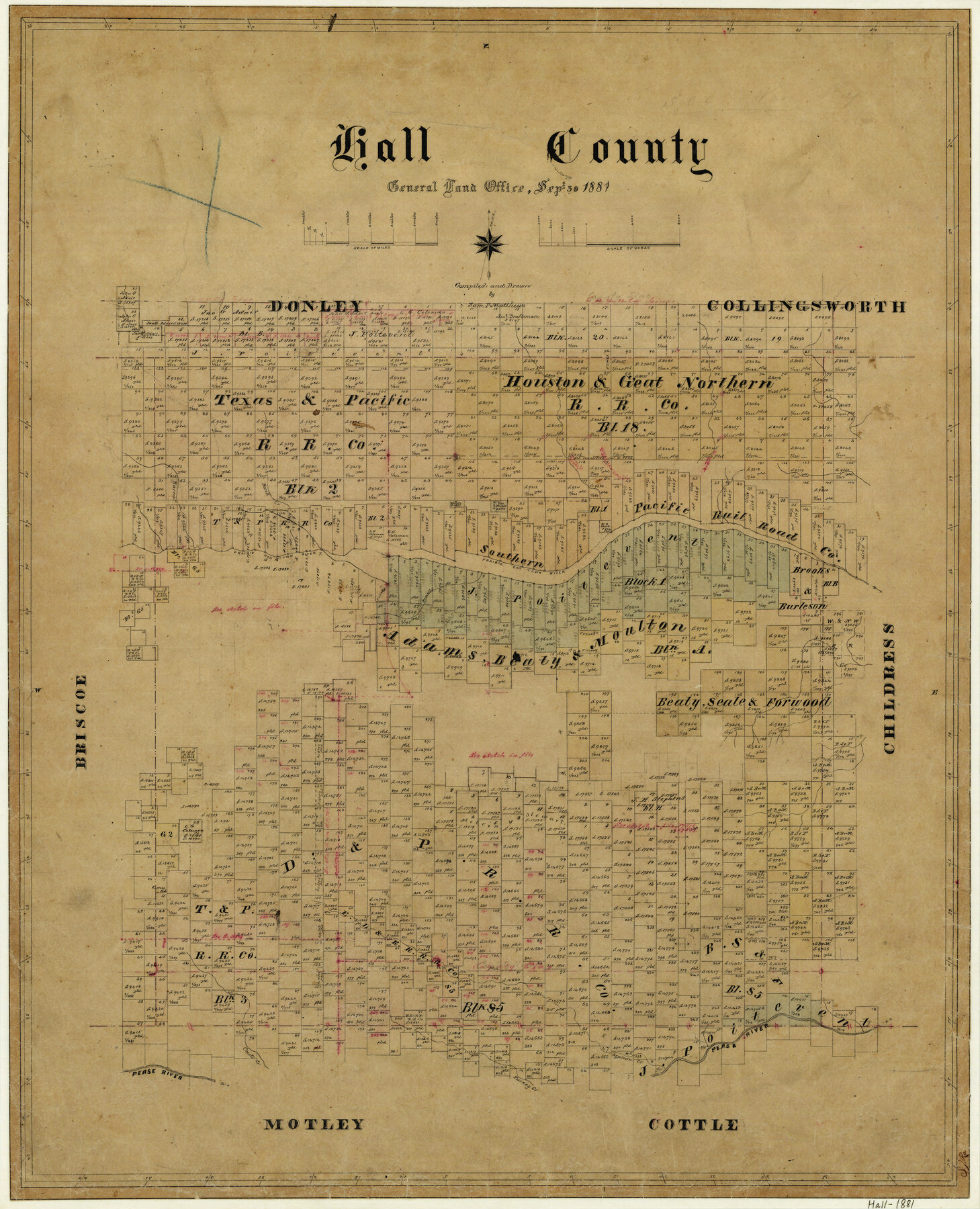
Hall County
-
Map/Doc
3616
-
Collection
General Map Collection
-
Object Dates
9/30/1881 (Creation Date)
-
People and Organizations
Sam. P. Matthews (Draftsman)
-
Counties
Hall
-
Subjects
County
-
Height x Width
26.2 x 21.1 inches
66.6 x 53.6 cm
-
Features
Mulberry Creek
Spring Creek
Indian Creek
Parker Creek
Morgan Creek
Prairie Dog Town River
Powells Creek
Bank Creek
Barnes Creek
Pease River
Couts Creek
Turkey Creek
Gypsum Creek
Bitter Creek
Bottle Creek
Part of: General Map Collection
[Surveys along Meridian Creek]
![242, [Surveys along Meridian Creek], General Map Collection](https://historictexasmaps.com/wmedia_w700/maps/242.tif.jpg)
Print $2.00
- Digital $50.00
[Surveys along Meridian Creek]
1846
Size 6.4 x 7.7 inches
Map/Doc 242
Wharton County

Print $20.00
- Digital $50.00
Wharton County
1946
Size 41.4 x 46.9 inches
Map/Doc 77455
Garza County Sketch File 4a

Print $4.00
- Digital $50.00
Garza County Sketch File 4a
1883
Size 14.2 x 8.8 inches
Map/Doc 24048


Flight Mission No. BQR-9K, Frame 54, Brazoria County

Print $20.00
- Digital $50.00
Flight Mission No. BQR-9K, Frame 54, Brazoria County
1952
Size 18.5 x 22.3 inches
Map/Doc 84058
Real County Working Sketch 78

Print $20.00
- Digital $50.00
Real County Working Sketch 78
1980
Size 33.9 x 35.5 inches
Map/Doc 71970

Harris County Rolled Sketch 67

Print $20.00
- Digital $50.00
Harris County Rolled Sketch 67
1940
Size 15.7 x 26.9 inches
Map/Doc 6109
Hudspeth County Rolled Sketch 66

Print $20.00
- Digital $50.00
Hudspeth County Rolled Sketch 66
1973
Size 11.9 x 20.5 inches
Map/Doc 6259
Flight Mission No. DQN-4K, Frame 5, Calhoun County

Print $20.00
- Digital $50.00
Flight Mission No. DQN-4K, Frame 5, Calhoun County
1953
Size 18.7 x 22.4 inches
Map/Doc 84370
Knox County Sketch File 10

Print $20.00
- Digital $50.00
Knox County Sketch File 10
1889
Size 20.1 x 12.8 inches
Map/Doc 11958
You may also like
Upton County Rolled Sketch 21

Print $20.00
- Digital $50.00
Upton County Rolled Sketch 21
1939
Size 21.5 x 37.9 inches
Map/Doc 8072
Haskell County

Print $20.00
- Digital $50.00
Haskell County
1879
Size 21.0 x 20.4 inches
Map/Doc 1127
Brewster County Rolled Sketch 24D

Print $20.00
- Digital $50.00
Brewster County Rolled Sketch 24D
1909
Size 14.6 x 17.4 inches
Map/Doc 5211
Harris County Working Sketch 66

Print $40.00
- Digital $50.00
Harris County Working Sketch 66
1955
Size 33.7 x 49.7 inches
Map/Doc 65958
Flight Mission No. DCL-7C, Frame 15, Kenedy County

Print $20.00
- Digital $50.00
Flight Mission No. DCL-7C, Frame 15, Kenedy County
1943
Size 15.4 x 15.3 inches
Map/Doc 86007
Kimble County Working Sketch 55

Print $20.00
- Digital $50.00
Kimble County Working Sketch 55
1954
Size 14.3 x 30.1 inches
Map/Doc 70123
Leon County Working Sketch 11

Print $20.00
- Digital $50.00
Leon County Working Sketch 11
1952
Size 21.1 x 35.0 inches
Map/Doc 70410
General Highway Map. Detail of Cities and Towns in Travis County, Texas. City Map, Austin and vicinity, Travis County, Texas

Print $20.00
General Highway Map. Detail of Cities and Towns in Travis County, Texas. City Map, Austin and vicinity, Travis County, Texas
1961
Size 18.1 x 24.7 inches
Map/Doc 79687
Castro County Rolled Sketch 12

Print $20.00
- Digital $50.00
Castro County Rolled Sketch 12
1945
Size 25.7 x 15.8 inches
Map/Doc 5421
Flight Mission No. DAG-24K, Frame 141, Matagorda County

Print $20.00
- Digital $50.00
Flight Mission No. DAG-24K, Frame 141, Matagorda County
1953
Size 18.5 x 22.4 inches
Map/Doc 86559
Austin County Boundary File 1

Print $44.00
- Digital $50.00
Austin County Boundary File 1
Size 7.0 x 8.2 inches
Map/Doc 50223
[Area around J. E. Arnold survey]
![91885, [Area around J. E. Arnold survey], Twichell Survey Records](https://historictexasmaps.com/wmedia_w700/maps/91885-1.tif.jpg)
Print $2.00
- Digital $50.00
[Area around J. E. Arnold survey]
Size 15.3 x 8.2 inches
Map/Doc 91885