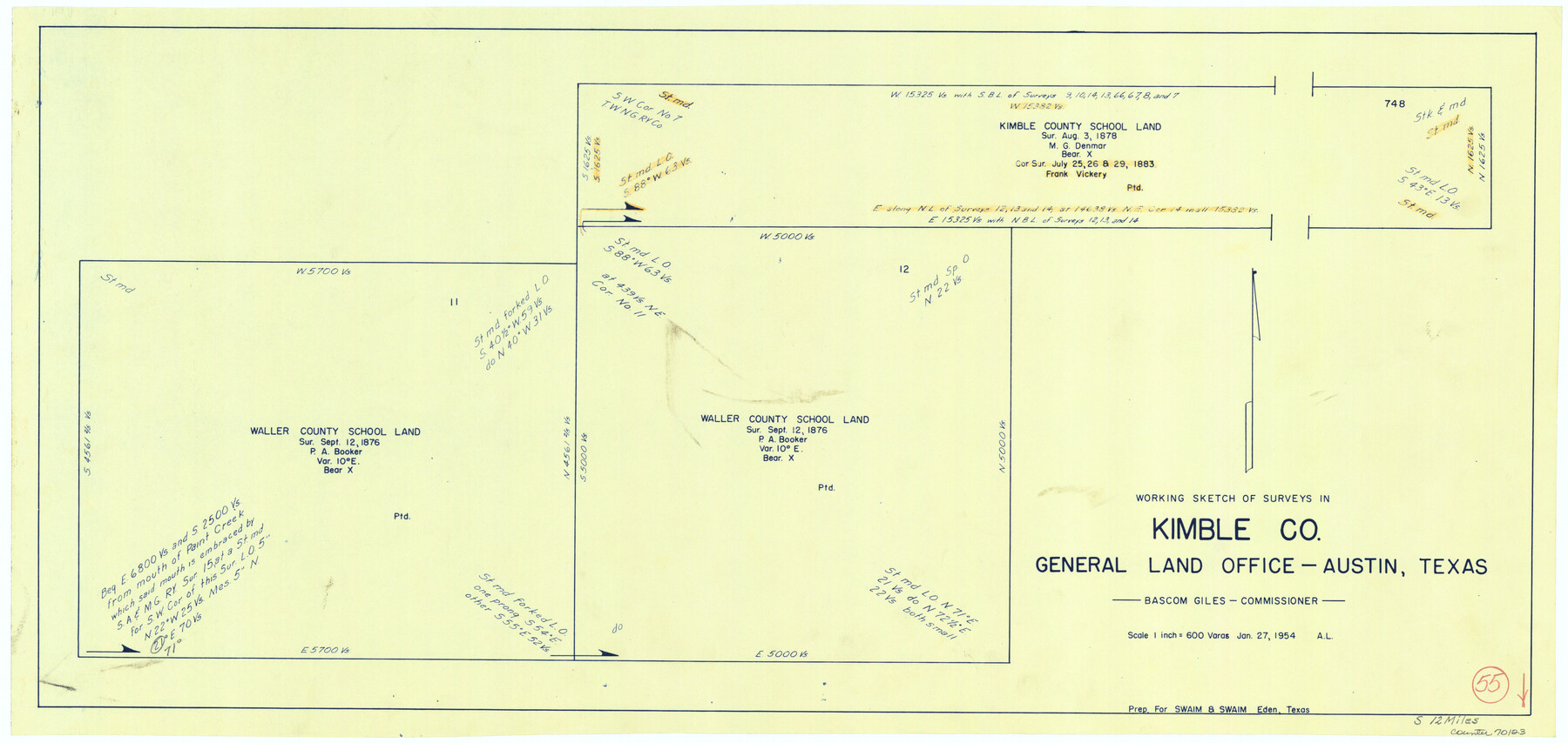
Kimble County Working Sketch 55
-
Map/Doc
70123
-
Collection
General Map Collection
-
Object Dates
1/27/1954 (Creation Date)
-
Counties
Kimble
-
Subjects
Surveying Working Sketch
-
Height x Width
14.3 x 30.1 inches
36.3 x 76.5 cm
-
Scale
1" = 600 varas
Part of: General Map Collection
Kinney County Sketch File 22

Print $6.00
- Digital $50.00
Kinney County Sketch File 22
1891
Size 10.1 x 12.3 inches
Map/Doc 29160
Baylor County Sketch File A5

Print $6.00
- Digital $50.00
Baylor County Sketch File A5
Size 10.4 x 8.8 inches
Map/Doc 14088
Ellis County Sketch File 4

Print $4.00
- Digital $50.00
Ellis County Sketch File 4
1859
Size 13.0 x 8.5 inches
Map/Doc 21832
Karnes County Working Sketch 7

Print $20.00
- Digital $50.00
Karnes County Working Sketch 7
1961
Size 20.8 x 24.2 inches
Map/Doc 66655
Jasper County Working Sketch 24
Print $40.00
- Digital $50.00
Jasper County Working Sketch 24
1948
Size 46.9 x 56.2 inches
Map/Doc 66486
Texas State Boundary Line 8

Print $170.00
Texas State Boundary Line 8
2000
Size 11.3 x 8.8 inches
Map/Doc 75054
Live Oak County Working Sketch 18

Print $20.00
- Digital $50.00
Live Oak County Working Sketch 18
1961
Size 30.2 x 29.6 inches
Map/Doc 70603
Brown County Working Sketch 3

Print $20.00
- Digital $50.00
Brown County Working Sketch 3
1919
Size 29.1 x 21.5 inches
Map/Doc 67768
Webb County Rolled Sketch 28

Print $20.00
- Digital $50.00
Webb County Rolled Sketch 28
1932
Size 27.5 x 20.6 inches
Map/Doc 8186
Pecos County Working Sketch 122

Print $40.00
- Digital $50.00
Pecos County Working Sketch 122
1973
Size 51.9 x 36.7 inches
Map/Doc 71595
Flight Mission No. BRE-3P, Frame 38, Nueces County

Print $20.00
- Digital $50.00
Flight Mission No. BRE-3P, Frame 38, Nueces County
1956
Size 18.5 x 22.4 inches
Map/Doc 86816
Flight Mission No. DQN-7K, Frame 40, Calhoun County

Print $20.00
- Digital $50.00
Flight Mission No. DQN-7K, Frame 40, Calhoun County
1953
Size 18.5 x 22.2 inches
Map/Doc 84478
You may also like
La Salle County Working Sketch 21

Print $20.00
- Digital $50.00
La Salle County Working Sketch 21
1942
Size 25.4 x 24.0 inches
Map/Doc 70322
County and Railroad Map of Texas

Print $20.00
- Digital $50.00
County and Railroad Map of Texas
1876
Size 17.0 x 16.0 inches
Map/Doc 93623
Stonewall County Sketch File 9

Print $10.00
- Digital $50.00
Stonewall County Sketch File 9
Size 8.1 x 7.9 inches
Map/Doc 37227
[Sketch of Potter County Road, North of River]
![93059, [Sketch of Potter County Road, North of River], Twichell Survey Records](https://historictexasmaps.com/wmedia_w700/maps/93059-1.tif.jpg)
Print $20.00
- Digital $50.00
[Sketch of Potter County Road, North of River]
Size 12.5 x 29.5 inches
Map/Doc 93059
Flight Mission No. BRE-2P, Frame 82, Nueces County

Print $20.00
- Digital $50.00
Flight Mission No. BRE-2P, Frame 82, Nueces County
1956
Size 18.5 x 22.6 inches
Map/Doc 86777
Roberts County Working Sketch 10

Print $20.00
- Digital $50.00
Roberts County Working Sketch 10
1965
Size 23.0 x 29.0 inches
Map/Doc 63536
Howard County Working Sketch 13

Print $20.00
- Digital $50.00
Howard County Working Sketch 13
1983
Size 33.3 x 37.3 inches
Map/Doc 66281
Starr County Rolled Sketch 45

Print $40.00
- Digital $50.00
Starr County Rolled Sketch 45
Size 17.7 x 57.5 inches
Map/Doc 9914
Witt Addition, Subdivision out of Section 6, Block E, City of Lubbock

Print $20.00
- Digital $50.00
Witt Addition, Subdivision out of Section 6, Block E, City of Lubbock
1950
Size 9.5 x 31.4 inches
Map/Doc 92738
The Castro Colony. February 15, 1842

Print $20.00
The Castro Colony. February 15, 1842
2020
Size 23.0 x 17.7 inches
Map/Doc 96357
Revised Sectional Map No. 5 showing land surveys in parts of counties of El Paso, Jeff Davis, Presidio and Brewster, Texas

Print $20.00
- Digital $50.00
Revised Sectional Map No. 5 showing land surveys in parts of counties of El Paso, Jeff Davis, Presidio and Brewster, Texas
Size 19.0 x 23.7 inches
Map/Doc 4476
Map of the Great Air Line Route, Ohio & Mississippi Railway and connections

Print $20.00
- Digital $50.00
Map of the Great Air Line Route, Ohio & Mississippi Railway and connections
1878
Size 12.8 x 26.4 inches
Map/Doc 95820