Garza County Sketch File 4a
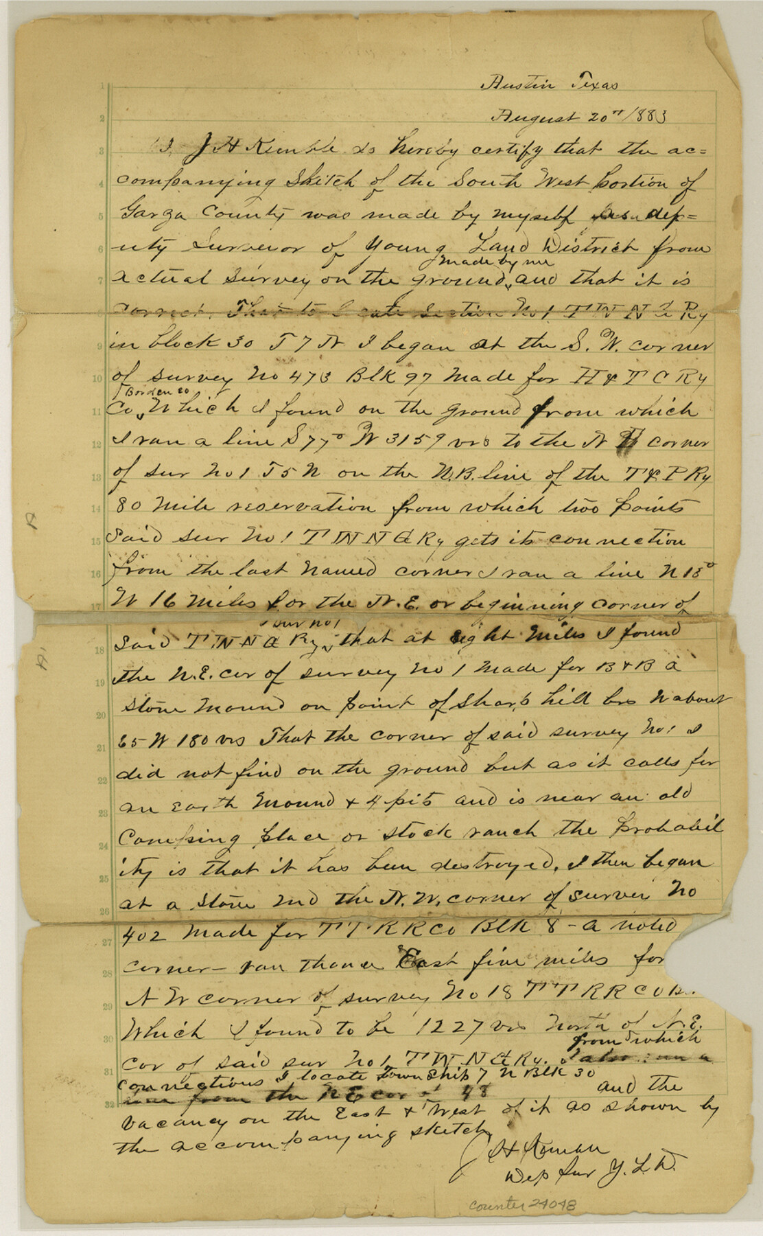
[Surveyor statement regarding southwest corner of Garza County]
-
Map/Doc
24048
-
Collection
General Map Collection
-
Object Dates
1883/8/20 (Creation Date)
-
People and Organizations
J.H. Kimble (Surveyor/Engineer)
-
Counties
Garza
-
Subjects
Surveying Sketch File
-
Height x Width
14.2 x 8.8 inches
36.1 x 22.4 cm
-
Medium
paper, manuscript
Part of: General Map Collection
Winkler County Sketch File 17

Print $18.00
- Digital $50.00
Winkler County Sketch File 17
1920
Size 14.3 x 8.6 inches
Map/Doc 40508
Motley County Sketch File 4 (N)

Print $20.00
- Digital $50.00
Motley County Sketch File 4 (N)
1882
Size 18.3 x 20.8 inches
Map/Doc 42137
Wichita County Rolled Sketch 2

Print $20.00
- Digital $50.00
Wichita County Rolled Sketch 2
1879
Size 20.6 x 26.3 inches
Map/Doc 78471
Lamb County Rolled Sketch 2

Print $20.00
- Digital $50.00
Lamb County Rolled Sketch 2
1917
Size 37.9 x 43.4 inches
Map/Doc 9412

Palo Pinto County Working Sketch 18

Print $20.00
- Digital $50.00
Palo Pinto County Working Sketch 18
1974
Size 30.5 x 37.3 inches
Map/Doc 71401
Taylor County Rolled Sketch 28

Print $20.00
- Digital $50.00
Taylor County Rolled Sketch 28
Size 34.4 x 23.9 inches
Map/Doc 7921
Old Miscellaneous File 30

Print $16.00
- Digital $50.00
Old Miscellaneous File 30
1845
Size 13.3 x 8.2 inches
Map/Doc 75740
Northeast Part of Webb County

Print $20.00
- Digital $50.00
Northeast Part of Webb County
1986
Size 34.6 x 45.7 inches
Map/Doc 77452
El Paso County

Print $40.00
- Digital $50.00
El Paso County
1881
Size 53.7 x 88.3 inches
Map/Doc 16826
Crockett County Rolled Sketch LO

Print $20.00
- Digital $50.00
Crockett County Rolled Sketch LO
Size 38.7 x 21.1 inches
Map/Doc 5638
Flight Mission No. CRK-3P, Frame 178, Refugio County

Print $20.00
- Digital $50.00
Flight Mission No. CRK-3P, Frame 178, Refugio County
1956
Size 18.4 x 22.2 inches
Map/Doc 86925
You may also like


Flight Mission No. DIX-6P, Frame 200, Aransas County

Print $20.00
- Digital $50.00
Flight Mission No. DIX-6P, Frame 200, Aransas County
1956
Size 19.0 x 22.7 inches
Map/Doc 83862
Val Verde County Working Sketch 17

Print $20.00
- Digital $50.00
Val Verde County Working Sketch 17
1926
Size 16.5 x 27.8 inches
Map/Doc 72152
Bosque County Sketch File 18

Print $4.00
- Digital $50.00
Bosque County Sketch File 18
1863
Size 13.5 x 8.4 inches
Map/Doc 14792
Sutton County Working Sketch 34

Print $20.00
- Digital $50.00
Sutton County Working Sketch 34
1939
Size 24.3 x 30.6 inches
Map/Doc 62377
Orange County Sketch File 8

Print $6.00
- Digital $50.00
Orange County Sketch File 8
Size 11.0 x 16.1 inches
Map/Doc 33311
[Sketch of part of Blks. B5, 6, 2Z, M6, M8, M11 and M15]
![89644, [Sketch of part of Blks. B5, 6, 2Z, M6, M8, M11 and M15], Twichell Survey Records](https://historictexasmaps.com/wmedia_w700/maps/89644-1.tif.jpg)
Print $40.00
- Digital $50.00
[Sketch of part of Blks. B5, 6, 2Z, M6, M8, M11 and M15]
Size 18.6 x 62.0 inches
Map/Doc 89644
Map of Bee County

Print $20.00
- Digital $50.00
Map of Bee County
1879
Size 25.1 x 22.7 inches
Map/Doc 3289
Martin County Rolled Sketch 4

Print $20.00
- Digital $50.00
Martin County Rolled Sketch 4
1908
Size 40.9 x 24.8 inches
Map/Doc 6665
Lloyd's Map of the Southern States showing all the Railroads, their Stations & Distances, also the Counties, Towns, Villages, Harbors, Rivers, and Forts

Print $40.00
- Digital $50.00
Lloyd's Map of the Southern States showing all the Railroads, their Stations & Distances, also the Counties, Towns, Villages, Harbors, Rivers, and Forts
1861
Size 39.3 x 54.4 inches
Map/Doc 96556
Flight Mission No. BRA-7M, Frame 145, Jefferson County

Print $20.00
- Digital $50.00
Flight Mission No. BRA-7M, Frame 145, Jefferson County
1953
Size 16.0 x 16.0 inches
Map/Doc 85539