San Patricio County Sketch File 35
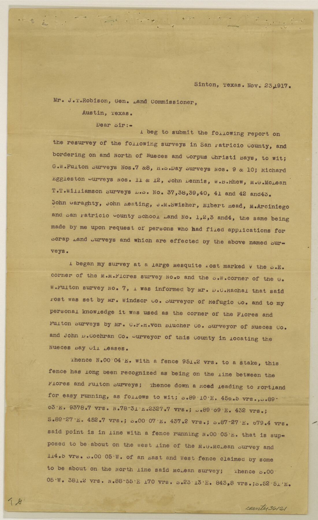
[Report of resurvey of the following surveys situated in San Patricio County, Texas: G.W. Fulton, H.S. Day, R. Eggleston, John Dennis, W.B. Rhew, M.G. McLean, T.T. Williamson, and more north of Nueces and Corpus Christi Bays]
-
Map/Doc
36121
-
Collection
General Map Collection
-
Object Dates
11/23/1917 (Creation Date)
10/2/1963 (File Date)
-
People and Organizations
H.A. Peabody (Surveyor/Engineer)
-
Counties
San Patricio
-
Subjects
Surveying Sketch File
-
Height x Width
14.5 x 8.8 inches
36.8 x 22.4 cm
-
Medium
paper, print
-
Comments
See San Patricio County Rolled Sketch 40 (7726) for sketch.
-
Features
Nueces Bay
Corpus Christi Bay
Portland
McGloin Bluff
Indian Point
SA&AP
Related maps
San Patricio County Rolled Sketch 40

Print $20.00
- Digital $50.00
San Patricio County Rolled Sketch 40
1917
Size 26.0 x 36.0 inches
Map/Doc 7726
Part of: General Map Collection
Hockley County Sketch File 9

Print $40.00
- Digital $50.00
Hockley County Sketch File 9
1912
Size 48.2 x 12.8 inches
Map/Doc 10491
Terrell County Working Sketch 75

Print $20.00
- Digital $50.00
Terrell County Working Sketch 75
1982
Size 41.4 x 43.7 inches
Map/Doc 69596
Lee County Working Sketch 10

Print $20.00
- Digital $50.00
Lee County Working Sketch 10
1979
Size 32.6 x 35.4 inches
Map/Doc 70389
Pottsboro Quadrangle

Print $20.00
- Digital $50.00
Pottsboro Quadrangle
1999
Size 35.4 x 23.4 inches
Map/Doc 97363

Scurry County Rolled Sketch 2

Print $20.00
- Digital $50.00
Scurry County Rolled Sketch 2
Size 44.0 x 44.9 inches
Map/Doc 9911
Map of the West Indies engraved to illustrate Mitchell's new intermediate geography

Print $20.00
- Digital $50.00
Map of the West Indies engraved to illustrate Mitchell's new intermediate geography
1885
Size 9.0 x 12.2 inches
Map/Doc 93524
[Beaumont, Sour Lake and Western Ry. Right of Way and Alignment - Frisco]
![64128, [Beaumont, Sour Lake and Western Ry. Right of Way and Alignment - Frisco], General Map Collection](https://historictexasmaps.com/wmedia_w700/maps/64128.tif.jpg)
Print $20.00
- Digital $50.00
[Beaumont, Sour Lake and Western Ry. Right of Way and Alignment - Frisco]
1910
Size 20.1 x 45.9 inches
Map/Doc 64128
Foard County Working Sketch 1

Print $20.00
- Digital $50.00
Foard County Working Sketch 1
1899
Size 20.5 x 22.8 inches
Map/Doc 69191
Culberson County Sketch File 2

Print $20.00
- Digital $50.00
Culberson County Sketch File 2
1882
Size 28.9 x 36.4 inches
Map/Doc 11261
Brewster County Sketch File N-11

Print $40.00
- Digital $50.00
Brewster County Sketch File N-11
Size 23.2 x 9.5 inches
Map/Doc 10965
Donley County Boundary File 6

Print $6.00
- Digital $50.00
Donley County Boundary File 6
Size 5.7 x 8.7 inches
Map/Doc 52637
You may also like
City of Austin, Texas and Suburban Territory

Print $40.00
- Digital $50.00
City of Austin, Texas and Suburban Territory
1952
Size 47.8 x 53.0 inches
Map/Doc 73583
Zapata County Working Sketch 13

Print $20.00
- Digital $50.00
Zapata County Working Sketch 13
1962
Size 28.7 x 29.6 inches
Map/Doc 62064
Nolan County Sketch File 16

Print $20.00
- Digital $50.00
Nolan County Sketch File 16
1938
Size 18.9 x 23.4 inches
Map/Doc 42166
Montgomery County Sketch File 5

Print $5.00
- Digital $50.00
Montgomery County Sketch File 5
Size 9.8 x 16.4 inches
Map/Doc 31779
Liberty County Working Sketch 35

Print $20.00
- Digital $50.00
Liberty County Working Sketch 35
1948
Size 22.3 x 42.3 inches
Map/Doc 70494
McLennan County Sketch File 4

Print $4.00
- Digital $50.00
McLennan County Sketch File 4
1852
Size 12.7 x 8.2 inches
Map/Doc 31235
Flight Mission No. DIX-6P, Frame 131, Aransas County

Print $20.00
- Digital $50.00
Flight Mission No. DIX-6P, Frame 131, Aransas County
1956
Size 19.5 x 23.0 inches
Map/Doc 83837
Cherokee County Working Sketch 3

Print $20.00
- Digital $50.00
Cherokee County Working Sketch 3
1934
Size 29.6 x 42.7 inches
Map/Doc 67958
Platte (sic) of the unorganized County School Lands in the District of Young

Print $20.00
- Digital $50.00
Platte (sic) of the unorganized County School Lands in the District of Young
Size 16.0 x 12.3 inches
Map/Doc 90453
Val Verde County Sketch File Z14

Print $20.00
- Digital $50.00
Val Verde County Sketch File Z14
1899
Size 22.1 x 20.6 inches
Map/Doc 12556
Gregg County Rolled Sketch 25

Print $40.00
- Digital $50.00
Gregg County Rolled Sketch 25
1933
Size 27.3 x 51.7 inches
Map/Doc 9076
Flight Mission No. BRE-2P, Frame 76, Nueces County

Print $20.00
- Digital $50.00
Flight Mission No. BRE-2P, Frame 76, Nueces County
1956
Size 18.4 x 22.4 inches
Map/Doc 86771