Hardin County Rolled Sketch 15
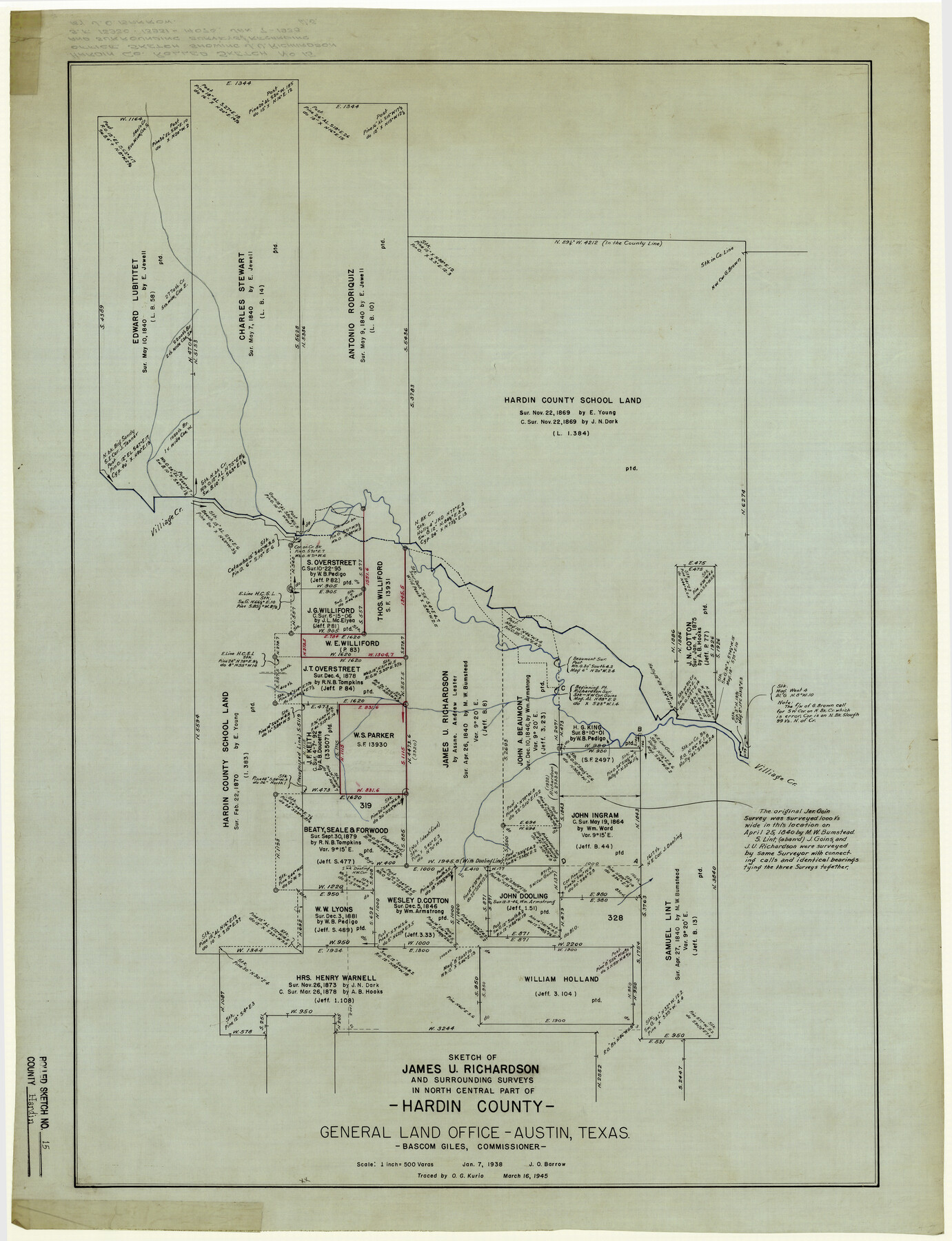
Sketch of James U. Richardson and surrounding surveys in north central part of Hardin County
-
Map/Doc
6084
-
Collection
General Map Collection
-
Object Dates
1/7/1938 (Creation Date)
3/16/1945 (Copy/Tracing Date)
-
People and Organizations
J.O. Barrow (Draftsman)
Otto G. Kurio (Draftsman)
-
Counties
Hardin
-
Subjects
Surveying Rolled Sketch
-
Height x Width
30.9 x 23.7 inches
78.5 x 60.2 cm
-
Medium
linen, manuscript
-
Scale
1" = 500 varas
Part of: General Map Collection
A2 - Part of the Boundary between the United States and Texas from Sabine River Northward to the 36th mile mound

Print $20.00
- Digital $50.00
A2 - Part of the Boundary between the United States and Texas from Sabine River Northward to the 36th mile mound
Size 28.5 x 22.0 inches
Map/Doc 94003
Central Part of Jeff Davis Co.

Print $40.00
- Digital $50.00
Central Part of Jeff Davis Co.
1982
Size 55.4 x 43.9 inches
Map/Doc 73193
El Paso County Working Sketch 5

Print $20.00
- Digital $50.00
El Paso County Working Sketch 5
1916
Size 21.5 x 37.2 inches
Map/Doc 69027
Lampasas County Sketch File 14

Print $6.00
- Digital $50.00
Lampasas County Sketch File 14
Size 16.2 x 10.5 inches
Map/Doc 29426
Comal County Working Sketch 3

Print $20.00
- Digital $50.00
Comal County Working Sketch 3
1944
Size 31.1 x 27.9 inches
Map/Doc 68169
Navigation Maps of Gulf Intracoastal Waterway, Port Arthur to Brownsville, Texas

Print $4.00
- Digital $50.00
Navigation Maps of Gulf Intracoastal Waterway, Port Arthur to Brownsville, Texas
1951
Size 16.7 x 21.5 inches
Map/Doc 65428
Houston Ship Channel, Alexander Island to Carpenter Bayou

Print $40.00
- Digital $50.00
Houston Ship Channel, Alexander Island to Carpenter Bayou
1989
Size 35.4 x 49.3 inches
Map/Doc 69915
Scurry County Sketch File 6

Print $14.00
- Digital $50.00
Scurry County Sketch File 6
2002
Size 11.2 x 8.7 inches
Map/Doc 76370
Limestone County Sketch File 23

Print $6.00
- Digital $50.00
Limestone County Sketch File 23
1908
Size 10.9 x 7.1 inches
Map/Doc 30203
Red River County Working Sketch 52

Print $20.00
- Digital $50.00
Red River County Working Sketch 52
1971
Size 35.5 x 24.7 inches
Map/Doc 72035
Garza County Rolled Sketch 11 & 11A

Print $31.00
- Digital $50.00
Garza County Rolled Sketch 11 & 11A
1915
Size 10.3 x 15.5 inches
Map/Doc 45214
La Salle County Working Sketch 5

Print $20.00
- Digital $50.00
La Salle County Working Sketch 5
1915
Size 17.2 x 13.4 inches
Map/Doc 70306
You may also like
Scurry County Rolled Sketch 9

Print $20.00
- Digital $50.00
Scurry County Rolled Sketch 9
1963
Size 23.0 x 22.0 inches
Map/Doc 7769
Culberson County Sketch File D

Print $32.00
- Digital $50.00
Culberson County Sketch File D
1915
Size 7.4 x 8.8 inches
Map/Doc 20189
Falls County Working Sketch 5

Print $40.00
- Digital $50.00
Falls County Working Sketch 5
2008
Size 34.3 x 56.6 inches
Map/Doc 88885
La Salle County Rolled Sketch 15

Print $20.00
- Digital $50.00
La Salle County Rolled Sketch 15
Size 22.0 x 32.4 inches
Map/Doc 6579
Flight Mission No. BRA-7M, Frame 31, Jefferson County

Print $20.00
- Digital $50.00
Flight Mission No. BRA-7M, Frame 31, Jefferson County
1953
Size 18.5 x 22.3 inches
Map/Doc 85482
Kimble County Working Sketch 86

Print $20.00
- Digital $50.00
Kimble County Working Sketch 86
1973
Size 39.3 x 25.6 inches
Map/Doc 70154
University of Texas System University Lands

Print $20.00
- Digital $50.00
University of Texas System University Lands
Size 17.8 x 23.4 inches
Map/Doc 93245
[Lynn County School Land Leagues 292, 293, PSL Block C-30, and D. W. RR. Co. Block H]
![90797, [Lynn County School Land Leagues 292, 293, PSL Block C-30, and D. W. RR. Co. Block H], Twichell Survey Records](https://historictexasmaps.com/wmedia_w700/maps/90797-1.tif.jpg)
Print $20.00
- Digital $50.00
[Lynn County School Land Leagues 292, 293, PSL Block C-30, and D. W. RR. Co. Block H]
Size 21.3 x 20.6 inches
Map/Doc 90797
Flight Mission No. BRA-9M, Frame 78, Jefferson County

Print $20.00
- Digital $50.00
Flight Mission No. BRA-9M, Frame 78, Jefferson County
1953
Size 18.5 x 22.5 inches
Map/Doc 85661


Mills County Working Sketch 19

Print $20.00
- Digital $50.00
Mills County Working Sketch 19
1963
Size 18.6 x 31.2 inches
Map/Doc 71049