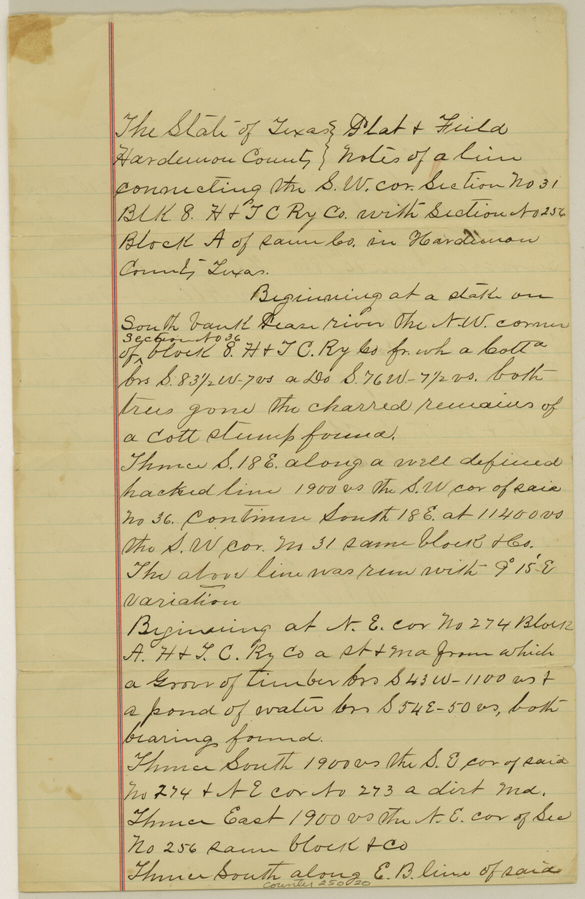
Hardeman County Sketch File 12
[W. J. Westmoreland connecting line]
-
Map/Doc
25020
-
Collection
General Map Collection
-
People and Organizations
F.C. Ratcliff (Chainman)
Joseph Allen (Chainman)
W.J. Westmoreland (Surveyor/Engineer)
-
Counties
Hardeman
-
Subjects
Surveying Sketch File
-
Height x Width
12.8 x 8.3 inches
32.5 x 21.1 cm
-
Medium
paper, manuscript
-
Features
Pease River
Part of: General Map Collection
Wichita County Sketch File 25

Print $20.00
- Digital $50.00
Wichita County Sketch File 25
1919
Size 17.6 x 22.3 inches
Map/Doc 12685
Map of Galveston West Bay, Galveston Island & Chocolate Bay

Print $40.00
- Digital $50.00
Map of Galveston West Bay, Galveston Island & Chocolate Bay
1852
Size 50.5 x 29.9 inches
Map/Doc 69924
Sutton County Working Sketch 3

Print $20.00
- Digital $50.00
Sutton County Working Sketch 3
1968
Size 23.6 x 34.5 inches
Map/Doc 62346
Hardin County Sketch File 39 and 40

Print $36.00
- Digital $50.00
Hardin County Sketch File 39 and 40
Size 8.4 x 13.2 inches
Map/Doc 25180
Sterling County Rolled Sketch 11

Print $20.00
- Digital $50.00
Sterling County Rolled Sketch 11
1884
Size 22.5 x 46.6 inches
Map/Doc 9945
Erath County Working Sketch 20

Print $20.00
- Digital $50.00
Erath County Working Sketch 20
1964
Size 16.3 x 22.0 inches
Map/Doc 69101
Kleberg County Rolled Sketch 10-8

Print $20.00
- Digital $50.00
Kleberg County Rolled Sketch 10-8
1951
Size 36.6 x 33.7 inches
Map/Doc 9370
King County Boundary File 5

Print $12.00
- Digital $50.00
King County Boundary File 5
Size 14.2 x 8.8 inches
Map/Doc 64916
Menard County Working Sketch 10

Print $20.00
- Digital $50.00
Menard County Working Sketch 10
1938
Size 21.8 x 18.5 inches
Map/Doc 70957
Flight Mission No. DAG-21K, Frame 93, Matagorda County

Print $20.00
- Digital $50.00
Flight Mission No. DAG-21K, Frame 93, Matagorda County
1952
Size 18.6 x 22.2 inches
Map/Doc 86422
Midland County Rolled Sketch 3

Print $40.00
- Digital $50.00
Midland County Rolled Sketch 3
Size 71.7 x 24.4 inches
Map/Doc 9514
Flight Mission No. DCL-5C, Frame 77, Kenedy County

Print $20.00
- Digital $50.00
Flight Mission No. DCL-5C, Frame 77, Kenedy County
1943
Size 18.5 x 22.4 inches
Map/Doc 85860
You may also like
General Highway Map, Ward County, Texas

Print $20.00
General Highway Map, Ward County, Texas
1961
Size 18.2 x 25.0 inches
Map/Doc 79702
Flight Mission No. BRA-7M, Frame 43, Jefferson County

Print $20.00
- Digital $50.00
Flight Mission No. BRA-7M, Frame 43, Jefferson County
1953
Size 18.6 x 22.4 inches
Map/Doc 85494
[Blocks C31-C37, D, D1, DD and vicinity]
![91870, [Blocks C31-C37, D, D1, DD and vicinity], Twichell Survey Records](https://historictexasmaps.com/wmedia_w700/maps/91870-1.tif.jpg)
Print $20.00
- Digital $50.00
[Blocks C31-C37, D, D1, DD and vicinity]
Size 21.1 x 15.3 inches
Map/Doc 91870

Intracoastal Waterway in Texas - Corpus Christi to Point Isabel including Arroyo Colorado to Mo. Pac. R.R. Bridge Near Harlingen

Print $20.00
- Digital $50.00
Intracoastal Waterway in Texas - Corpus Christi to Point Isabel including Arroyo Colorado to Mo. Pac. R.R. Bridge Near Harlingen
1933
Size 28.1 x 40.9 inches
Map/Doc 61851
Concho County Working Sketch 17

Print $20.00
- Digital $50.00
Concho County Working Sketch 17
1956
Size 20.9 x 23.4 inches
Map/Doc 68199
Taylor County Rolled Sketch 19

Print $20.00
- Digital $50.00
Taylor County Rolled Sketch 19
1886
Size 23.5 x 30.8 inches
Map/Doc 7913
Lubbock County Sketch File 14

Print $4.00
- Digital $50.00
Lubbock County Sketch File 14
1892
Size 11.2 x 8.9 inches
Map/Doc 30438
Starr County Sketch File 17

Print $24.00
- Digital $50.00
Starr County Sketch File 17
1880
Size 12.8 x 8.2 inches
Map/Doc 36874
McLennan County Sketch File 43

Print $4.00
- Digital $50.00
McLennan County Sketch File 43
1873
Size 10.0 x 8.1 inches
Map/Doc 31333
Val Verde County Rolled Sketch 38

Print $20.00
- Digital $50.00
Val Verde County Rolled Sketch 38
Size 30.4 x 19.5 inches
Map/Doc 61781
Gregg County Rolled Sketch 21

Print $20.00
- Digital $50.00
Gregg County Rolled Sketch 21
1957
Size 34.4 x 40.4 inches
Map/Doc 10650