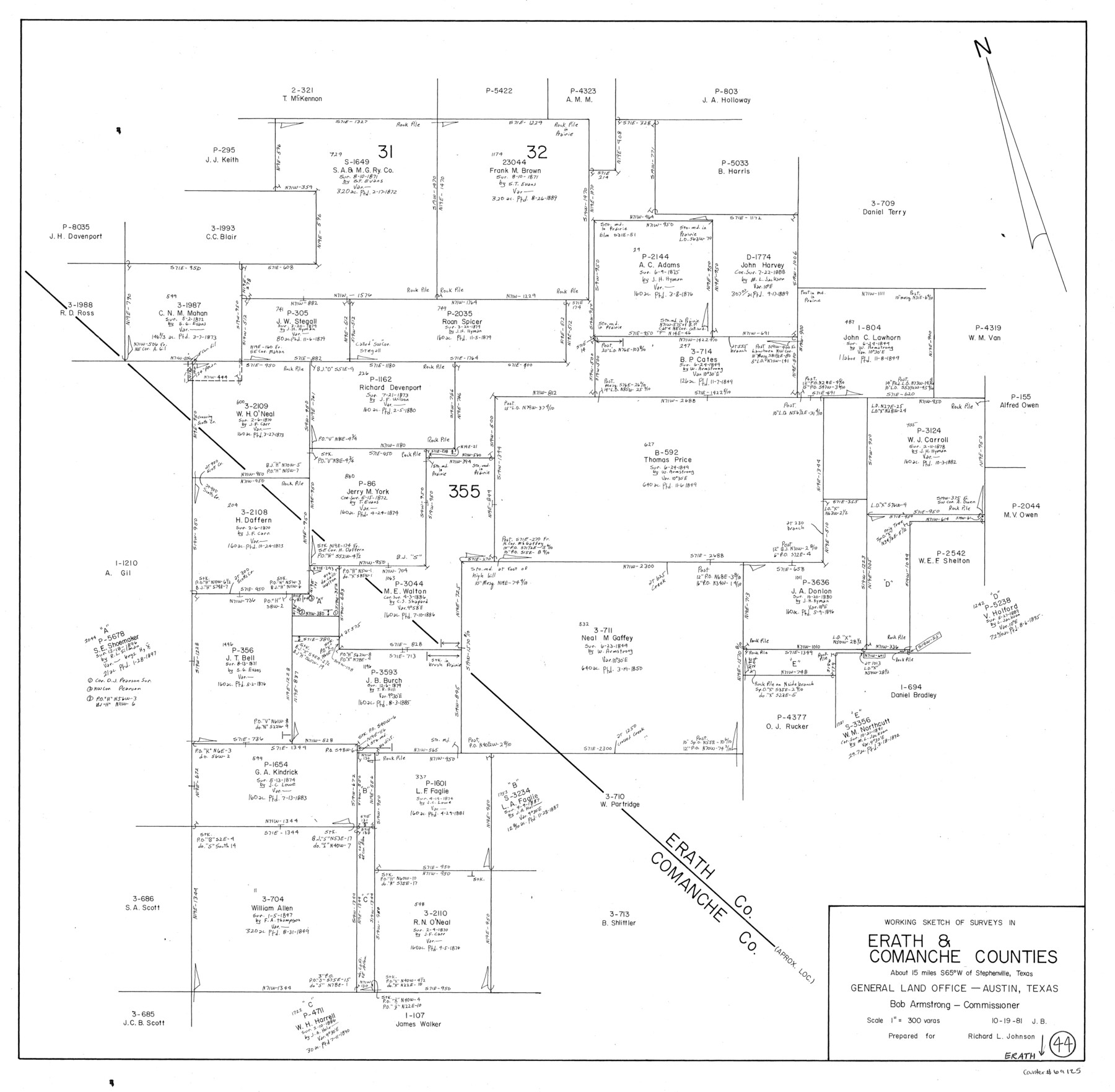
Erath County Working Sketch 44
-
Map/Doc
69125
-
Collection
General Map Collection
-
Object Dates
10/19/1981 (Creation Date)
-
People and Organizations
Jana Brod (Draftsman)
-
Counties
Erath Comanche
-
Subjects
Surveying Working Sketch
-
Height x Width
29.7 x 30.4 inches
75.4 x 77.2 cm
-
Scale
1" = 300 varas
Part of: General Map Collection
Henderson County Boundary File 3b

Print $14.00
- Digital $50.00
Henderson County Boundary File 3b
Size 14.4 x 8.9 inches
Map/Doc 54700
Dawson County Sketch File A1

Print $20.00
- Digital $50.00
Dawson County Sketch File A1
1923
Size 14.8 x 33.4 inches
Map/Doc 11299
Dallas County Sketch File 1

Print $4.00
- Digital $50.00
Dallas County Sketch File 1
1853
Size 7.2 x 7.0 inches
Map/Doc 20394
Upton County Rolled Sketch 36

Print $40.00
- Digital $50.00
Upton County Rolled Sketch 36
1952
Size 42.9 x 64.2 inches
Map/Doc 10051
Photo Index of Texas Coast - Sheet 5 of 6

Print $20.00
- Digital $50.00
Photo Index of Texas Coast - Sheet 5 of 6
1954
Size 20.0 x 24.0 inches
Map/Doc 83443
Val Verde County Rolled Sketch 60

Print $20.00
- Digital $50.00
Val Verde County Rolled Sketch 60
1951
Size 32.4 x 20.4 inches
Map/Doc 8127
Right of Way and Track Map, International & Gt. Northern Ry. operated by the International & Gt. Northern Ry. Co. Gulf Division, Mineola Branch

Print $40.00
- Digital $50.00
Right of Way and Track Map, International & Gt. Northern Ry. operated by the International & Gt. Northern Ry. Co. Gulf Division, Mineola Branch
1917
Size 25.4 x 121.1 inches
Map/Doc 64702
Upton County Rolled Sketch 48

Print $20.00
- Digital $50.00
Upton County Rolled Sketch 48
1958
Size 27.8 x 27.9 inches
Map/Doc 10694
Denton County Working Sketch 36

Print $20.00
- Digital $50.00
Denton County Working Sketch 36
2008
Size 18.5 x 29.0 inches
Map/Doc 88877
[Galveston, Harrisburg & San Antonio through El Paso County]
![64009, [Galveston, Harrisburg & San Antonio through El Paso County], General Map Collection](https://historictexasmaps.com/wmedia_w700/maps/64009.tif.jpg)
Print $20.00
- Digital $50.00
[Galveston, Harrisburg & San Antonio through El Paso County]
1906
Size 13.6 x 33.8 inches
Map/Doc 64009
Chambers County Boundary File 1

Print $28.00
- Digital $50.00
Chambers County Boundary File 1
Size 8.9 x 6.7 inches
Map/Doc 51226
Pecos County Working Sketch 66

Print $20.00
- Digital $50.00
Pecos County Working Sketch 66
1955
Size 25.8 x 21.2 inches
Map/Doc 71538
You may also like
Rains County Boundary File 1

Print $6.00
- Digital $50.00
Rains County Boundary File 1
Size 11.3 x 8.8 inches
Map/Doc 58090
Flight Mission No. BRA-9M, Frame 76, Jefferson County

Print $20.00
- Digital $50.00
Flight Mission No. BRA-9M, Frame 76, Jefferson County
1953
Size 18.5 x 22.5 inches
Map/Doc 85659
Bird's Eye View of Bastrop, Bastrop County, Texas

Print $20.00
Bird's Eye View of Bastrop, Bastrop County, Texas
1887
Size 18.8 x 25.7 inches
Map/Doc 89073
Lamb County Working Sketch 2

Print $20.00
- Digital $50.00
Lamb County Working Sketch 2
1919
Size 13.6 x 15.3 inches
Map/Doc 70275
Uvalde County Working Sketch 15

Print $20.00
- Digital $50.00
Uvalde County Working Sketch 15
1945
Size 18.5 x 26.9 inches
Map/Doc 72085
Webb County Sketch File VOLP

Print $40.00
- Digital $50.00
Webb County Sketch File VOLP
1937
Size 18.9 x 33.8 inches
Map/Doc 12607
Burleson County Working Sketch 26

Print $20.00
- Digital $50.00
Burleson County Working Sketch 26
1981
Size 10.1 x 30.5 inches
Map/Doc 67745
Polk County Sketch File 11a

Print $4.00
- Digital $50.00
Polk County Sketch File 11a
Size 8.1 x 9.7 inches
Map/Doc 34144
Chambers County Sketch File Y

Print $4.00
- Digital $50.00
Chambers County Sketch File Y
1907
Size 14.3 x 8.7 inches
Map/Doc 17600
Township 2 South Range 11 West, South Western District, Louisiana

Print $20.00
- Digital $50.00
Township 2 South Range 11 West, South Western District, Louisiana
1882
Size 19.6 x 24.6 inches
Map/Doc 65881
Dimmit County Boundary File 10

Print $32.00
- Digital $50.00
Dimmit County Boundary File 10
Size 14.2 x 8.6 inches
Map/Doc 52604
Hardeman County Aerial Photograph Index Sheet 5

Print $20.00
- Digital $50.00
Hardeman County Aerial Photograph Index Sheet 5
1950
Size 19.0 x 16.9 inches
Map/Doc 83701