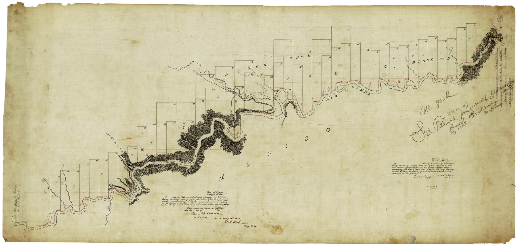
Hudspeth County Rolled Sketch 14
[Sketch of T. & P. Ry. Co. Block 3 along Rio Grande]
-
Map/Doc
9202
-
Collection
General Map Collection
-
Object Dates
1885 (Creation Date)
5/30/1885 (File Date)
-
People and Organizations
Sam H. Wade (Surveyor/Engineer)
-
Counties
Hudspeth
-
Subjects
Surveying Rolled Sketch
-
Height x Width
17.1 x 35.9 inches
43.4 x 91.2 cm
-
Medium
paper, manuscript
Part of: General Map Collection
Louisiana and Texas Intracoastal Waterway, Section 7, Galveston Bay to Brazos River and Section 8, Brazos River to Matagorda Bay

Print $20.00
- Digital $50.00
Louisiana and Texas Intracoastal Waterway, Section 7, Galveston Bay to Brazos River and Section 8, Brazos River to Matagorda Bay
1929
Size 30.8 x 43.0 inches
Map/Doc 61841
Lampasas County Sketch File 2

Print $40.00
- Digital $50.00
Lampasas County Sketch File 2
1858
Size 15.6 x 12.7 inches
Map/Doc 29390
Reagan County Sketch File 22

Print $6.00
- Digital $50.00
Reagan County Sketch File 22
1939
Size 11.4 x 8.9 inches
Map/Doc 35013
Flight Mission No. BQR-13K, Frame 119, Brazoria County

Print $20.00
- Digital $50.00
Flight Mission No. BQR-13K, Frame 119, Brazoria County
1952
Size 19.0 x 22.6 inches
Map/Doc 84080
Lampasas County Working Sketch 21

Print $20.00
- Digital $50.00
Lampasas County Working Sketch 21
1988
Size 15.2 x 26.7 inches
Map/Doc 70299
Starr County Sketch File 46

Print $20.00
- Digital $50.00
Starr County Sketch File 46
1949
Size 23.3 x 26.6 inches
Map/Doc 12343
Dimmit County Sketch File 34

Print $4.00
- Digital $50.00
Dimmit County Sketch File 34
1884
Size 9.0 x 8.7 inches
Map/Doc 21153
San Jacinto County Working Sketch 44

Print $20.00
- Digital $50.00
San Jacinto County Working Sketch 44
1981
Size 20.6 x 11.4 inches
Map/Doc 63758
Donley County Working Sketch 4

Print $20.00
- Digital $50.00
Donley County Working Sketch 4
1958
Size 44.0 x 39.8 inches
Map/Doc 68737
Lubbock County Boundary File 1

Print $64.00
- Digital $50.00
Lubbock County Boundary File 1
Size 8.8 x 8.6 inches
Map/Doc 56455
Shelby County Rolled Sketch 5

Print $20.00
- Digital $50.00
Shelby County Rolled Sketch 5
1942
Size 37.9 x 43.7 inches
Map/Doc 9921
Map of Taylor County Travis- Young- Bexar- Land District

Print $20.00
- Digital $50.00
Map of Taylor County Travis- Young- Bexar- Land District
1859
Size 25.1 x 20.4 inches
Map/Doc 4071
You may also like
[Beaumont, Sour Lake and Western Ry. Right of Way and Alignment - Frisco]
![64118, [Beaumont, Sour Lake and Western Ry. Right of Way and Alignment - Frisco], General Map Collection](https://historictexasmaps.com/wmedia_w700/maps/64118.tif.jpg)
Print $20.00
- Digital $50.00
[Beaumont, Sour Lake and Western Ry. Right of Way and Alignment - Frisco]
1910
Size 20.1 x 46.1 inches
Map/Doc 64118
Flight Mission No. CUG-1P, Frame 23, Kleberg County

Print $20.00
- Digital $50.00
Flight Mission No. CUG-1P, Frame 23, Kleberg County
1956
Size 18.5 x 22.1 inches
Map/Doc 86113
Kimble County Sketch File 6

Print $4.00
- Digital $50.00
Kimble County Sketch File 6
Size 6.4 x 8.0 inches
Map/Doc 28918

Typical Scenes of Wichita Falls and District

Print $20.00
- Digital $50.00
Typical Scenes of Wichita Falls and District
1927
Size 13.7 x 16.6 inches
Map/Doc 96761
[Sketch showing San Augustine, Morris, Stephens and Eastland School Land Leagues and adjacent Blocks]
![89918, [Sketch showing San Augustine, Morris, Stephens and Eastland School Land Leagues and adjacent Blocks], Twichell Survey Records](https://historictexasmaps.com/wmedia_w700/maps/89918-1.tif.jpg)
Print $40.00
- Digital $50.00
[Sketch showing San Augustine, Morris, Stephens and Eastland School Land Leagues and adjacent Blocks]
Size 54.7 x 43.5 inches
Map/Doc 89918
Map of the Panhandle Railway

Print $40.00
- Digital $50.00
Map of the Panhandle Railway
1888
Size 22.6 x 114.7 inches
Map/Doc 64461
[Maps of surveys in Reeves & Culberson Cos]
![61134, [Maps of surveys in Reeves & Culberson Cos], General Map Collection](https://historictexasmaps.com/wmedia_w700/maps/61134.tif.jpg)
Print $20.00
- Digital $50.00
[Maps of surveys in Reeves & Culberson Cos]
1937
Size 30.7 x 24.9 inches
Map/Doc 61134
Dimmit County Sketch File 30

Print $4.00
- Digital $50.00
Dimmit County Sketch File 30
Size 10.6 x 8.5 inches
Map/Doc 21146
Fort Bend Co.

Print $20.00
- Digital $50.00
Fort Bend Co.
1931
Size 40.2 x 41.8 inches
Map/Doc 95500
Flight Mission No. DIX-10P, Frame 167, Aransas County

Print $20.00
- Digital $50.00
Flight Mission No. DIX-10P, Frame 167, Aransas County
1956
Size 18.6 x 22.3 inches
Map/Doc 83957
Fisher County Sketch File 15a

Print $10.00
- Digital $50.00
Fisher County Sketch File 15a
1901
Size 7.6 x 9.0 inches
Map/Doc 22578