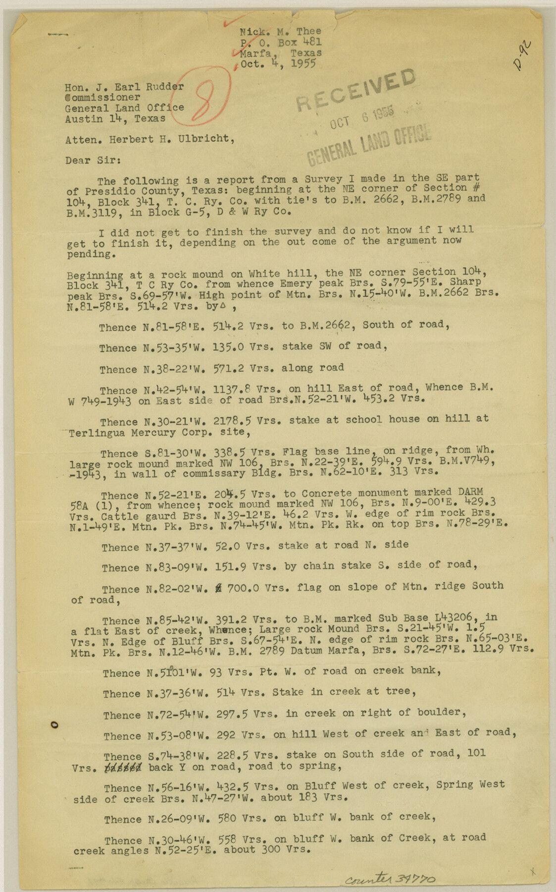
Presidio County Sketch File 94
[Report and field notes in southeast part of county]
-
Map/Doc
34770
-
Collection
General Map Collection
-
Object Dates
10/4/1955 (Creation Date)
10/24/1960 (File Date)
10/4/1955 (Correspondence Date)
-
People and Organizations
Nick M. Thee (Surveyor/Engineer)
-
Counties
Presidio
-
Subjects
Surveying Sketch File
-
Height x Width
14.2 x 8.8 inches
36.1 x 22.4 cm
-
Medium
paper, manuscript
-
Features
Emery Peak
White Hill
Part of: General Map Collection
San Jacinto County Rolled Sketch 13

Print $20.00
- Digital $50.00
San Jacinto County Rolled Sketch 13
1994
Size 32.2 x 23.7 inches
Map/Doc 7562
Hutchinson County Working Sketch 19

Print $20.00
- Digital $50.00
Hutchinson County Working Sketch 19
1960
Size 18.8 x 18.3 inches
Map/Doc 66379
Cherokee County Sketch File 11

Print $4.00
- Digital $50.00
Cherokee County Sketch File 11
1852
Size 11.5 x 8.2 inches
Map/Doc 18138
Trinity County Sketch File 43

Print $40.00
- Digital $50.00
Trinity County Sketch File 43
1854
Size 19.2 x 23.6 inches
Map/Doc 12495
Newton County Sketch File 13

Print $22.00
- Digital $50.00
Newton County Sketch File 13
Size 8.1 x 12.7 inches
Map/Doc 32386
Kleberg County Rolled Sketch 10-5

Print $20.00
- Digital $50.00
Kleberg County Rolled Sketch 10-5
1951
Size 37.6 x 35.6 inches
Map/Doc 9394
Shelby County Working Sketch 29

Print $20.00
- Digital $50.00
Shelby County Working Sketch 29
2000
Size 19.6 x 29.9 inches
Map/Doc 63883
Culberson County Rolled Sketch 65

Print $20.00
- Digital $50.00
Culberson County Rolled Sketch 65
1987
Size 23.7 x 18.8 inches
Map/Doc 5681
Kimble County

Print $40.00
- Digital $50.00
Kimble County
1930
Size 41.0 x 49.0 inches
Map/Doc 77340
Culberson County Working Sketch 15

Print $20.00
- Digital $50.00
Culberson County Working Sketch 15
1923
Size 19.9 x 21.5 inches
Map/Doc 68467
Topographical Map of the Rio Grande, Sheet No. 1

Print $20.00
- Digital $50.00
Topographical Map of the Rio Grande, Sheet No. 1
1912
Map/Doc 89525
McLennan County Working Sketch 2

Print $20.00
- Digital $50.00
McLennan County Working Sketch 2
1941
Size 21.8 x 30.0 inches
Map/Doc 70695
You may also like
Pecos County Boundary File 69

Print $22.00
- Digital $50.00
Pecos County Boundary File 69
Size 7.8 x 3.4 inches
Map/Doc 57890
Garza County Sketch File 8

Print $8.00
- Digital $50.00
Garza County Sketch File 8
1900
Size 10.3 x 8.2 inches
Map/Doc 24062
Flight Mission No. DAG-18K, Frame 76, Matagorda County

Print $20.00
- Digital $50.00
Flight Mission No. DAG-18K, Frame 76, Matagorda County
1952
Size 17.5 x 22.1 inches
Map/Doc 86369
Crockett County Working Sketch 31

Print $20.00
- Digital $50.00
Crockett County Working Sketch 31
1924
Size 37.2 x 33.5 inches
Map/Doc 68364
Pecos County Sketch File 114

Print $18.00
- Digital $50.00
Pecos County Sketch File 114
1912
Size 13.3 x 8.9 inches
Map/Doc 34074
Fannin County Working Sketch 1

Print $20.00
- Digital $50.00
Fannin County Working Sketch 1
1904
Size 27.6 x 19.5 inches
Map/Doc 69155

Lee County Working Sketch 4

Print $20.00
- Digital $50.00
Lee County Working Sketch 4
1973
Size 17.1 x 18.4 inches
Map/Doc 70383
Upshur County

Print $20.00
- Digital $50.00
Upshur County
1945
Size 39.8 x 35.8 inches
Map/Doc 73308
San Antonio Bay and Vicinity in Aransas and Calhoun Counties, showing Subdivsion for Mineral Development

Print $40.00
- Digital $50.00
San Antonio Bay and Vicinity in Aransas and Calhoun Counties, showing Subdivsion for Mineral Development
1948
Size 37.0 x 74.5 inches
Map/Doc 1912
Blanco County Rolled Sketch 19

Print $20.00
- Digital $50.00
Blanco County Rolled Sketch 19
Size 20.4 x 17.0 inches
Map/Doc 76409
Val Verde County Working Sketch 52

Print $20.00
- Digital $50.00
Val Verde County Working Sketch 52
1956
Size 20.6 x 14.9 inches
Map/Doc 72187