Kleberg County Rolled Sketch 10-5
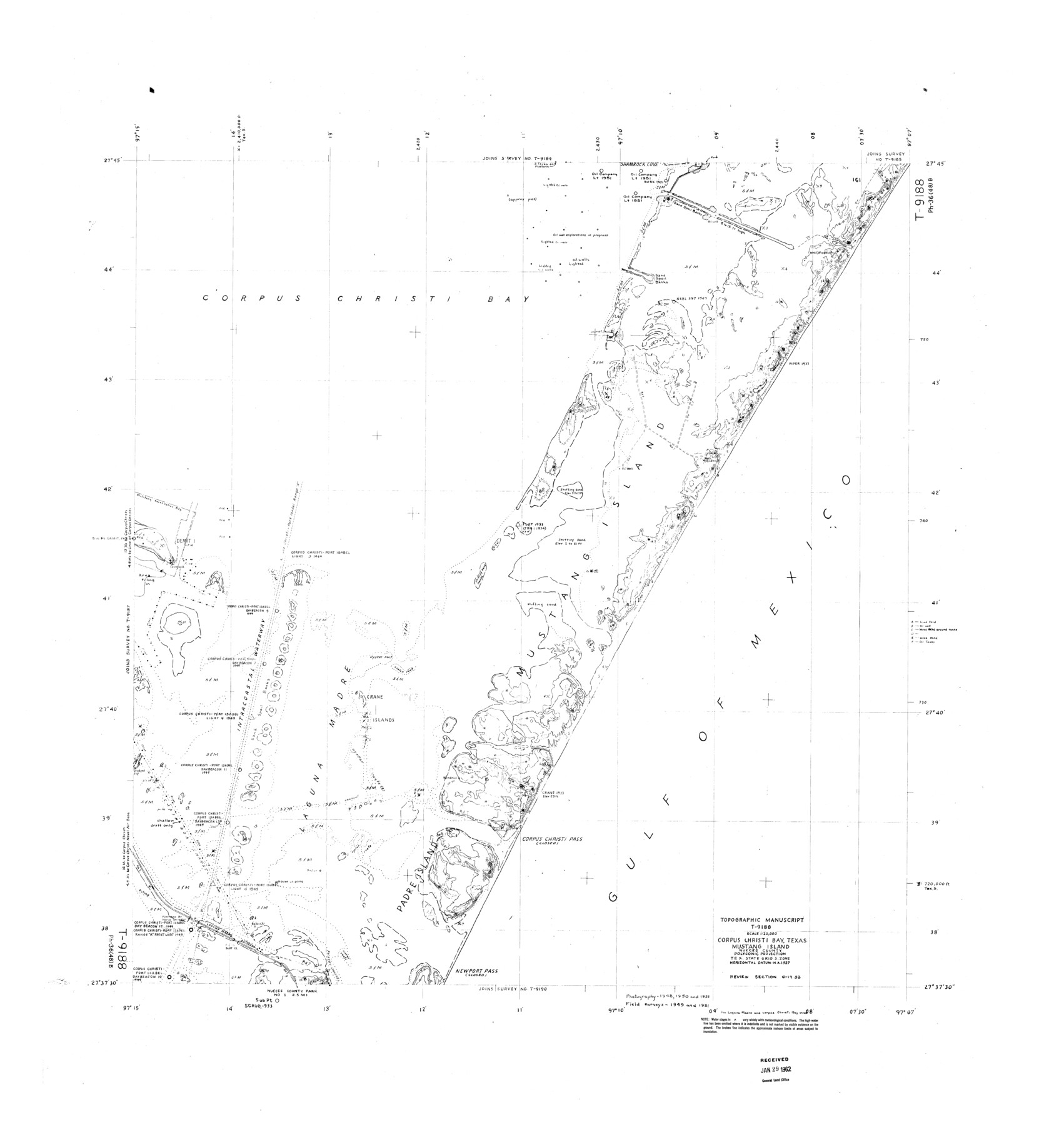
Topographic Manuscript T-9188, Corpus Christi Bay, Texas, Mustang Island, Nueces County
-
Map/Doc
9394
-
Collection
General Map Collection
-
Object Dates
1951 (Creation Date)
1962/1/29 (File Date)
-
Counties
Nueces
-
Subjects
Surveying Rolled Sketch
-
Height x Width
37.6 x 35.6 inches
95.5 x 90.4 cm
Part of: General Map Collection
McCulloch County Rolled Sketch 1

Print $20.00
- Digital $50.00
McCulloch County Rolled Sketch 1
Size 44.4 x 36.9 inches
Map/Doc 9495
Map of Matagorda Bay and County with the Adjacent Country

Print $20.00
- Digital $50.00
Map of Matagorda Bay and County with the Adjacent Country
1839
Size 33.4 x 42.6 inches
Map/Doc 2002
Fractional Township No. 8 South Range No. 6 East of the Indian Meridian, Indian Territory

Print $20.00
- Digital $50.00
Fractional Township No. 8 South Range No. 6 East of the Indian Meridian, Indian Territory
1898
Size 19.3 x 24.4 inches
Map/Doc 75210
[Peter's Colony surveys in Stephens County]
![75986, [Peter's Colony surveys in Stephens County], General Map Collection](https://historictexasmaps.com/wmedia_w700/maps/75986.tif.jpg)
Print $20.00
- Digital $50.00
[Peter's Colony surveys in Stephens County]
Size 25.3 x 21.1 inches
Map/Doc 75986
Hopkins County Sketch File 10

Print $4.00
- Digital $50.00
Hopkins County Sketch File 10
1856
Size 9.1 x 8.2 inches
Map/Doc 26700
Padre Island National Seashore

Print $4.00
- Digital $50.00
Padre Island National Seashore
Size 16.1 x 22.3 inches
Map/Doc 60538
[Travis District]
![88740, [Travis District], General Map Collection](https://historictexasmaps.com/wmedia_w700/maps/88740.tif.jpg)
Print $40.00
- Digital $50.00
[Travis District]
1840
Size 54.7 x 46.0 inches
Map/Doc 88740
National Railways of Mexico

Digital $50.00
National Railways of Mexico
1966
Size 8.9 x 17.6 inches
Map/Doc 94189

Flight Mission No. DQN-5K, Frame 56, Calhoun County

Print $20.00
- Digital $50.00
Flight Mission No. DQN-5K, Frame 56, Calhoun County
1953
Size 15.7 x 15.5 inches
Map/Doc 84399
Map of Eastland Co.

Print $20.00
- Digital $50.00
Map of Eastland Co.
1896
Size 40.8 x 43.8 inches
Map/Doc 66809
Wise County Sketch File 51

Print $2.00
- Digital $50.00
Wise County Sketch File 51
Size 8.5 x 3.9 inches
Map/Doc 40618
You may also like
El Paso County Working Sketch 56

Print $40.00
- Digital $50.00
El Paso County Working Sketch 56
1971
Size 65.7 x 43.4 inches
Map/Doc 69078
Childress County Sketch File 18

Print $8.00
- Digital $50.00
Childress County Sketch File 18
1909
Size 14.3 x 9.0 inches
Map/Doc 18290
No. 2 Chart of Corpus Christi Pass, Texas

Print $20.00
- Digital $50.00
No. 2 Chart of Corpus Christi Pass, Texas
1878
Size 18.3 x 27.3 inches
Map/Doc 73014
Reeves County Working Sketch 11

Print $20.00
- Digital $50.00
Reeves County Working Sketch 11
1957
Size 27.7 x 36.9 inches
Map/Doc 63454
Liberty County Rolled Sketch 15

Print $20.00
- Digital $50.00
Liberty County Rolled Sketch 15
2015
Size 36.1 x 24.3 inches
Map/Doc 94022
King County Boundary File 1

Print $46.00
- Digital $50.00
King County Boundary File 1
Size 14.2 x 8.6 inches
Map/Doc 64873
Archer County Sketch File 18

Print $40.00
- Digital $50.00
Archer County Sketch File 18
Size 23.9 x 13.0 inches
Map/Doc 10828
[T. C. & S. F. Block K11, Capitol Leagues 367, 373, 374, and Blocks D and B]
![90536, [T. C. & S. F. Block K11, Capitol Leagues 367, 373, 374, and Blocks D and B], Twichell Survey Records](https://historictexasmaps.com/wmedia_w700/maps/90536-1.tif.jpg)
Print $3.00
- Digital $50.00
[T. C. & S. F. Block K11, Capitol Leagues 367, 373, 374, and Blocks D and B]
1903
Size 9.5 x 13.7 inches
Map/Doc 90536
Presidio County Rolled Sketch 105B

Print $20.00
- Digital $50.00
Presidio County Rolled Sketch 105B
Size 46.5 x 36.5 inches
Map/Doc 9789
Texas Intracoastal Waterway - Stover Point to Port Brownsville including Brazos Santiago

Print $20.00
- Digital $50.00
Texas Intracoastal Waterway - Stover Point to Port Brownsville including Brazos Santiago
1965
Size 27.5 x 38.9 inches
Map/Doc 73521
Gray County Sketch File 14

Print $4.00
- Digital $50.00
Gray County Sketch File 14
1946
Size 11.3 x 8.9 inches
Map/Doc 24457
Floyd County Working Sketch 5

Print $20.00
- Digital $50.00
Floyd County Working Sketch 5
1955
Size 33.3 x 23.6 inches
Map/Doc 69184