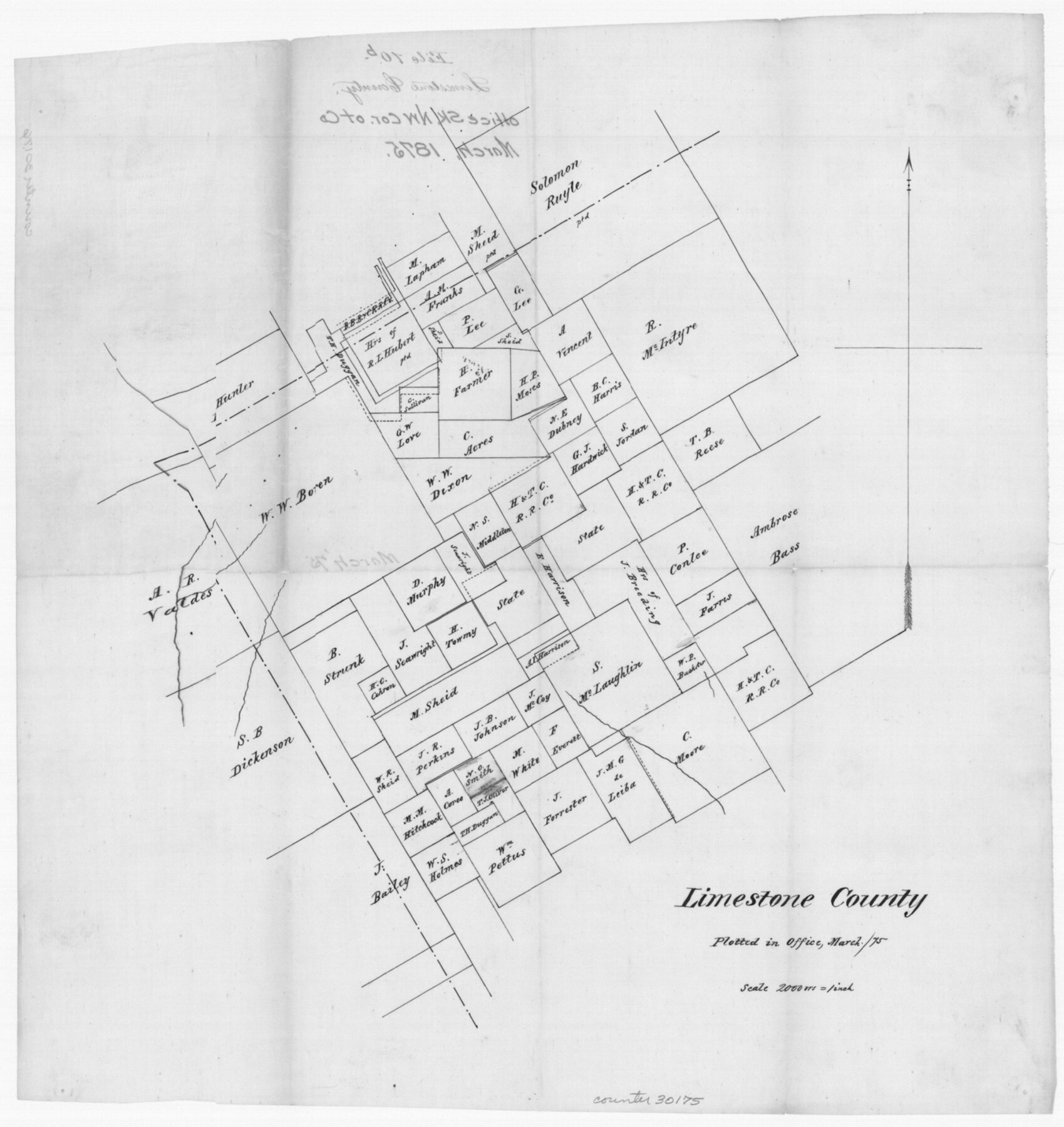
Limestone County Sketch File 10b
[Office sketch in the northwest corner of the county]
-
Map/Doc
30175
-
Collection
General Map Collection
-
Object Dates
3/1875 (Creation Date)
3/1875 (File Date)
-
Counties
Limestone McLennan Hill
-
Subjects
Surveying Sketch File
-
Height x Width
15.0 x 14.1 inches
38.1 x 35.8 cm
-
Medium
paper, manuscript
-
Scale
1:2000
Part of: General Map Collection
Orange County Working Sketch 9

Print $3.00
- Digital $50.00
Orange County Working Sketch 9
1922
Size 10.6 x 11.6 inches
Map/Doc 71341

Martin County Boundary File 2b

Print $40.00
- Digital $50.00
Martin County Boundary File 2b
Size 46.4 x 20.2 inches
Map/Doc 56779
Pecos County Rolled Sketch 145

Print $20.00
- Digital $50.00
Pecos County Rolled Sketch 145
1957
Size 37.2 x 27.6 inches
Map/Doc 7278
Flight Mission No. BRA-16M, Frame 94, Jefferson County

Print $20.00
- Digital $50.00
Flight Mission No. BRA-16M, Frame 94, Jefferson County
1953
Size 18.5 x 22.1 inches
Map/Doc 85706
McMullen County Rolled Sketch 16

Print $20.00
- Digital $50.00
McMullen County Rolled Sketch 16
1949
Size 30.2 x 25.0 inches
Map/Doc 6733
Galveston Harbor, Texas - U.S. Harbor Lines - Galveston Harbor, Galveston Channel, Channel from Galveston Harbor to Texas City and Channel to Port Bolivar

Print $20.00
- Digital $50.00
Galveston Harbor, Texas - U.S. Harbor Lines - Galveston Harbor, Galveston Channel, Channel from Galveston Harbor to Texas City and Channel to Port Bolivar
1939
Size 39.4 x 26.7 inches
Map/Doc 73631
Sabine County Working Sketch 3

Print $3.00
- Digital $50.00
Sabine County Working Sketch 3
1911
Size 10.8 x 15.7 inches
Map/Doc 63674
Hudspeth County Rolled Sketch 47

Print $20.00
- Digital $50.00
Hudspeth County Rolled Sketch 47
1963
Size 22.2 x 25.9 inches
Map/Doc 6255
Cherokee County Sketch File 33

Print $16.00
- Digital $50.00
Cherokee County Sketch File 33
1935
Size 11.5 x 7.2 inches
Map/Doc 18190
Map of the Survey of the Parallel 36 1/2 Degrees North Latitude, Commencing at the 100th and Running to the 103rd Degree of Longitude West of Greenwich

Print $40.00
- Digital $50.00
Map of the Survey of the Parallel 36 1/2 Degrees North Latitude, Commencing at the 100th and Running to the 103rd Degree of Longitude West of Greenwich
1862
Size 115.6 x 14.9 inches
Map/Doc 73566
Madison County Working Sketch 12

Print $40.00
- Digital $50.00
Madison County Working Sketch 12
1965
Size 41.7 x 48.5 inches
Map/Doc 70774
You may also like
Hardin County Sketch File 36

Print $4.00
- Digital $50.00
Hardin County Sketch File 36
Size 12.5 x 8.1 inches
Map/Doc 25178
El Paso County Rolled Sketch 43B

Print $20.00
- Digital $50.00
El Paso County Rolled Sketch 43B
Size 22.0 x 22.0 inches
Map/Doc 5830
Flight Mission No. CGI-3N, Frame 49, Cameron County

Print $20.00
- Digital $50.00
Flight Mission No. CGI-3N, Frame 49, Cameron County
1954
Size 18.8 x 22.4 inches
Map/Doc 84555
Texas Coordinate File 3

Print $40.00
- Digital $50.00
Texas Coordinate File 3
Size 36.1 x 49.1 inches
Map/Doc 75306
Lampasas County Sketch File 16 1/2

Print $4.00
- Digital $50.00
Lampasas County Sketch File 16 1/2
Size 8.4 x 8.6 inches
Map/Doc 29428
Brown County Sketch File 31

Print $6.00
- Digital $50.00
Brown County Sketch File 31
Size 17.0 x 11.0 inches
Map/Doc 16643
Bell County Sketch File 15

Print $4.00
- Digital $50.00
Bell County Sketch File 15
1861
Size 6.4 x 8.0 inches
Map/Doc 14394
Schleicher County Sketch File 48

Print $4.00
- Digital $50.00
Schleicher County Sketch File 48
1953
Size 11.2 x 8.7 inches
Map/Doc 36558
Flight Mission No. BRE-1P, Frame 7, Nueces County

Print $20.00
- Digital $50.00
Flight Mission No. BRE-1P, Frame 7, Nueces County
1956
Size 18.3 x 22.1 inches
Map/Doc 86615
City of Port Aransas

Print $40.00
- Digital $50.00
City of Port Aransas
1990
Size 25.2 x 53.3 inches
Map/Doc 3213
Briscoe County Sketch File L

Print $40.00
- Digital $50.00
Briscoe County Sketch File L
1935
Size 30.4 x 27.4 inches
Map/Doc 11009
Map of Ellis County

Print $20.00
- Digital $50.00
Map of Ellis County
1889
Size 38.9 x 47.7 inches
Map/Doc 4941