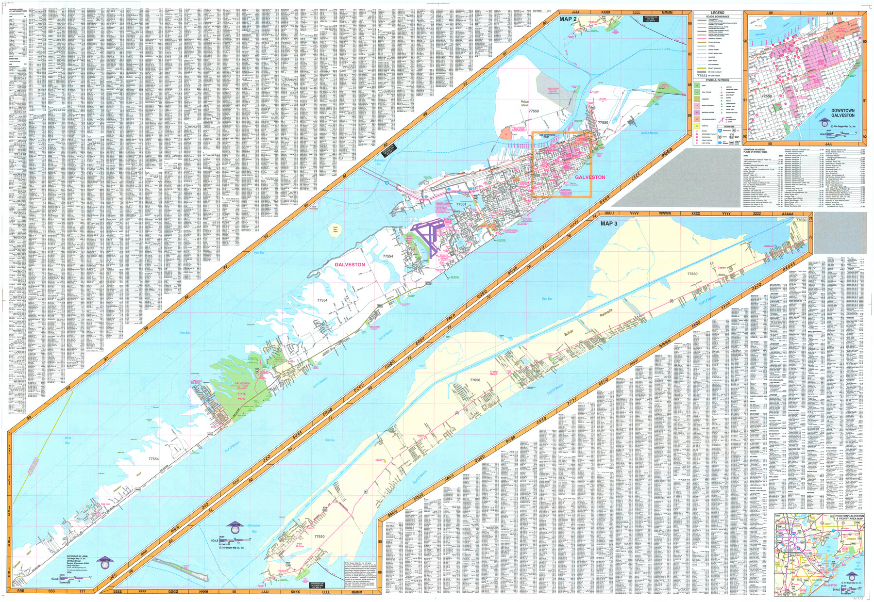
Galveston - Texas City, Texas
Map 2/Map 3 [Galveston Island]
-
Map/Doc
96858
-
Collection
General Map Collection
-
Object Dates
2008 (Creation Date)
-
People and Organizations
The Seeger Map Co., Inc. (Publisher)
Mark Lambert (Donor)
-
Counties
Galveston
-
Subjects
City
-
Height x Width
26.9 x 39.0 inches
68.3 x 99.1 cm
-
Medium
paper, print
-
Comments
For research only. Donated by Mark Lambert in May, 2022. See 96857 for recto.
Related maps

Part of: General Map Collection
Mason County Sketch File 24

Print $22.00
- Digital $50.00
Mason County Sketch File 24
1959
Size 15.0 x 15.2 inches
Map/Doc 30726
Right of Way & Track Map Houston & Brazos Valley Ry. operated by Houston & Brazos Valley Ry. Co., Hoskins Mound Branch

Print $40.00
- Digital $50.00
Right of Way & Track Map Houston & Brazos Valley Ry. operated by Houston & Brazos Valley Ry. Co., Hoskins Mound Branch
1924
Size 25.3 x 56.4 inches
Map/Doc 64609
[Letters to and from Maj. W. J. Powell regarding surveys of Texas and Pacific Ry. Lands west of the Pecos. Blks 53-55, Township 1 & 2 map within]
![2249, [Letters to and from Maj. W. J. Powell regarding surveys of Texas and Pacific Ry. Lands west of the Pecos. Blks 53-55, Township 1 & 2 map within], General Map Collection](https://historictexasmaps.com/wmedia_w700/pdf_converted_jpg/qi_pdf_thumbnail_1039.jpg)
Print $124.00
- Digital $50.00
[Letters to and from Maj. W. J. Powell regarding surveys of Texas and Pacific Ry. Lands west of the Pecos. Blks 53-55, Township 1 & 2 map within]
1934
Size 10.2 x 15.4 inches
Map/Doc 2249
Presidio County Sketch File 87

Print $6.00
- Digital $50.00
Presidio County Sketch File 87
1951
Size 14.5 x 8.7 inches
Map/Doc 34748
Harris County Boundary File 39

Print $40.00
- Digital $50.00
Harris County Boundary File 39
Size 9.1 x 3.9 inches
Map/Doc 54306
Harris County Sketch File 104

Print $2.00
- Digital $50.00
Harris County Sketch File 104
1992
Size 11.2 x 8.9 inches
Map/Doc 25974

Flight Mission No. CLL-1N, Frame 39, Willacy County

Print $20.00
- Digital $50.00
Flight Mission No. CLL-1N, Frame 39, Willacy County
1954
Size 18.4 x 22.0 inches
Map/Doc 87020
Limestone County Sketch File 4

Print $20.00
- Digital $50.00
Limestone County Sketch File 4
1847
Size 15.2 x 34.1 inches
Map/Doc 12001
Gulf of Mexico

Print $20.00
- Digital $50.00
Gulf of Mexico
1905
Size 18.3 x 26.8 inches
Map/Doc 72653

Sutton County Sketch File 5

Print $40.00
- Digital $50.00
Sutton County Sketch File 5
Size 14.0 x 17.3 inches
Map/Doc 37356
You may also like
Kerr County Working Sketch 3

Print $20.00
- Digital $50.00
Kerr County Working Sketch 3
1944
Size 15.7 x 21.0 inches
Map/Doc 70034
Lavaca County Sketch File 5

Print $4.00
- Digital $50.00
Lavaca County Sketch File 5
1858
Size 8.2 x 10.1 inches
Map/Doc 29639
Part of Laguna Madre in Nueces and Kleberg Counties, showing Subdivision for Mineral Development

Print $20.00
- Digital $50.00
Part of Laguna Madre in Nueces and Kleberg Counties, showing Subdivision for Mineral Development
1948
Size 42.0 x 30.3 inches
Map/Doc 1921
General Highway Map, Stonewall County, Texas

Print $20.00
General Highway Map, Stonewall County, Texas
1961
Size 18.3 x 25.1 inches
Map/Doc 79662
Milam County Working Sketch 5

Print $20.00
- Digital $50.00
Milam County Working Sketch 5
1963
Size 29.1 x 23.7 inches
Map/Doc 71020
General Highway Map Cochran County, Texas

Print $40.00
- Digital $50.00
General Highway Map Cochran County, Texas
1942
Size 37.4 x 50.1 inches
Map/Doc 89851
Map showing eight tidal areas in Oso Bay and Oso Creek, Nueces County, Texas offered for Mineral Development

Print $20.00
- Digital $50.00
Map showing eight tidal areas in Oso Bay and Oso Creek, Nueces County, Texas offered for Mineral Development
1936
Size 17.9 x 29.7 inches
Map/Doc 2067
Jones County Boundary File 1a

Print $40.00
- Digital $50.00
Jones County Boundary File 1a
1882
Size 37.9 x 39.2 inches
Map/Doc 44358
Reagan County Sketch File 16

Print $8.00
- Digital $50.00
Reagan County Sketch File 16
1932
Size 11.1 x 7.7 inches
Map/Doc 35002
Caldwell County Sketch File 1

Print $22.00
- Digital $50.00
Caldwell County Sketch File 1
Size 8.6 x 12.4 inches
Map/Doc 35825
Harris County Working Sketch 100

Print $20.00
- Digital $50.00
Harris County Working Sketch 100
1979
Size 29.9 x 31.3 inches
Map/Doc 65992
McMullen County Rolled Sketch 22

Print $20.00
- Digital $50.00
McMullen County Rolled Sketch 22
2004
Size 15.3 x 24.6 inches
Map/Doc 88824