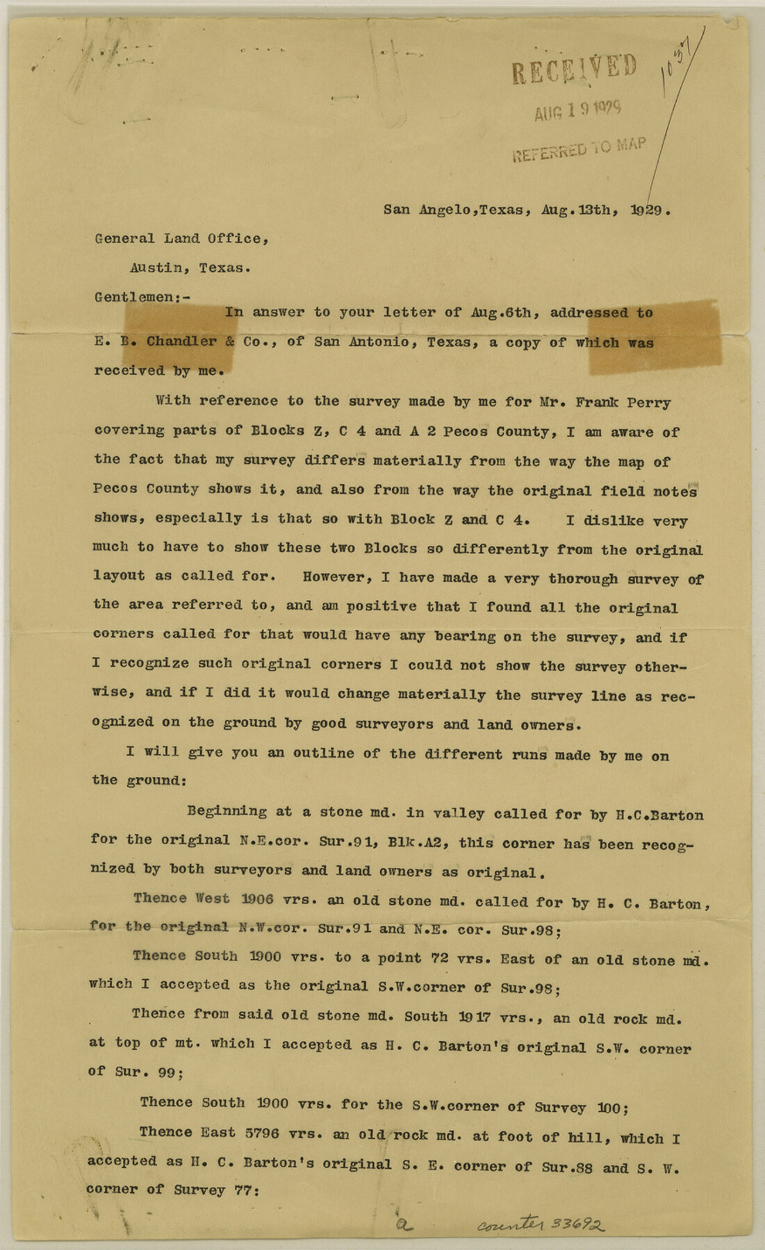
Pecos County Sketch File 29b
[Corrections in regard to survey in the name of Frank Perry]
-
Map/Doc
33692
-
Collection
General Map Collection
-
Object Dates
1929/8/13 (Creation Date)
1929/8/19 (File Date)
1929/8/13 (Correspondence Date)
-
People and Organizations
J.A. Simpson (Surveyor/Engineer)
H.C. Barton (Surveyor/Engineer)
Goodfellow (Surveyor/Engineer)
Mr. George (Surveyor/Engineer)
Zant (Surveyor/Engineer)
R.S. Dod (Surveyor/Engineer)
-
Counties
Pecos
-
Subjects
Surveying Sketch File
-
Height x Width
14.3 x 8.8 inches
36.3 x 22.4 cm
-
Medium
paper, print
-
Features
Cap Stone Mountain
Part of: General Map Collection
Llano County Boundary File 3

Print $42.00
- Digital $50.00
Llano County Boundary File 3
Size 14.1 x 8.7 inches
Map/Doc 56449
Mitchell County Boundary File 1

Print $38.00
- Digital $50.00
Mitchell County Boundary File 1
Size 9.1 x 8.4 inches
Map/Doc 57334
Sutton County Sketch File 57

Print $24.00
- Digital $50.00
Sutton County Sketch File 57
1961
Size 11.2 x 8.8 inches
Map/Doc 37542
The American Union Railroad Map of the United States, British Possessions, West Indies, Mexico, and Central America

Print $40.00
- Digital $50.00
The American Union Railroad Map of the United States, British Possessions, West Indies, Mexico, and Central America
1873
Size 40.2 x 58.2 inches
Map/Doc 97124
Tom Green County

Print $20.00
- Digital $50.00
Tom Green County
1856
Size 23.3 x 27.7 inches
Map/Doc 4089
Dickens County Sketch File 37

Print $8.00
- Digital $50.00
Dickens County Sketch File 37
Size 10.3 x 8.3 inches
Map/Doc 21044
Presidio County Sketch File 118

Print $16.00
- Digital $50.00
Presidio County Sketch File 118
Size 14.3 x 8.9 inches
Map/Doc 34919
Irion County Boundary File 4a

Print $40.00
- Digital $50.00
Irion County Boundary File 4a
Size 8.6 x 38.7 inches
Map/Doc 55361
Culberson County Working Sketch 19

Print $20.00
- Digital $50.00
Culberson County Working Sketch 19
1933
Size 30.0 x 43.6 inches
Map/Doc 68471
Flight Mission No. DQN-2K, Frame 65, Calhoun County

Print $20.00
- Digital $50.00
Flight Mission No. DQN-2K, Frame 65, Calhoun County
1953
Size 18.5 x 22.2 inches
Map/Doc 84257
Copy of Surveyor's Field Book, Morris Browning - In Blocks 7, 5 & 4, I&GNRRCo., Hutchinson and Carson Counties, Texas

Print $2.00
- Digital $50.00
Copy of Surveyor's Field Book, Morris Browning - In Blocks 7, 5 & 4, I&GNRRCo., Hutchinson and Carson Counties, Texas
1888
Size 7.0 x 8.9 inches
Map/Doc 62268
Ward County Working Sketch 45

Print $40.00
- Digital $50.00
Ward County Working Sketch 45
1973
Size 56.8 x 28.3 inches
Map/Doc 72351
You may also like
[Plat showing well locations]
![91667, [Plat showing well locations], Twichell Survey Records](https://historictexasmaps.com/wmedia_w700/maps/91667-1.tif.jpg)
Print $3.00
- Digital $50.00
[Plat showing well locations]
Size 13.3 x 11.3 inches
Map/Doc 91667
Jefferson County NRC Article 33.136 Sketch 1

Print $20.00
- Digital $50.00
Jefferson County NRC Article 33.136 Sketch 1
2002
Size 24.0 x 36.1 inches
Map/Doc 61601
[Sketch for Mineral Application 13439 - Old River, Walle Merritt]
![65689, [Sketch for Mineral Application 13439 - Old River, Walle Merritt], General Map Collection](https://historictexasmaps.com/wmedia_w700/maps/65689-1.tif.jpg)
Print $20.00
- Digital $50.00
[Sketch for Mineral Application 13439 - Old River, Walle Merritt]
1925
Size 41.0 x 19.0 inches
Map/Doc 65689
Eastland County Working Sketch 3

Print $20.00
- Digital $50.00
Eastland County Working Sketch 3
1917
Size 16.5 x 20.2 inches
Map/Doc 68784
Map of Fort Bend Co.

Print $20.00
- Digital $50.00
Map of Fort Bend Co.
1906
Size 38.4 x 43.8 inches
Map/Doc 87154
Working Sketch Hale County

Print $20.00
- Digital $50.00
Working Sketch Hale County
1909
Size 17.9 x 20.9 inches
Map/Doc 90745
[Sketch of Blks. 2, 2B, 3B]
![89638, [Sketch of Blks. 2, 2B, 3B], Twichell Survey Records](https://historictexasmaps.com/wmedia_w700/maps/89638-1.tif.jpg)
Print $20.00
- Digital $50.00
[Sketch of Blks. 2, 2B, 3B]
1918
Size 38.0 x 33.2 inches
Map/Doc 89638

Lipscomb County Rolled Sketch 5

Print $40.00
- Digital $50.00
Lipscomb County Rolled Sketch 5
Size 61.8 x 8.1 inches
Map/Doc 10640
The Republic County of Brazoria. December 29, 1845

Print $20.00
The Republic County of Brazoria. December 29, 1845
2020
Size 14.7 x 21.8 inches
Map/Doc 96115
Edwards County Working Sketch Graphic Index - west part

Print $40.00
- Digital $50.00
Edwards County Working Sketch Graphic Index - west part
1975
Size 57.4 x 38.1 inches
Map/Doc 76532
Rusk County Working Sketch 23

Print $20.00
- Digital $50.00
Rusk County Working Sketch 23
1949
Size 23.9 x 26.5 inches
Map/Doc 63659