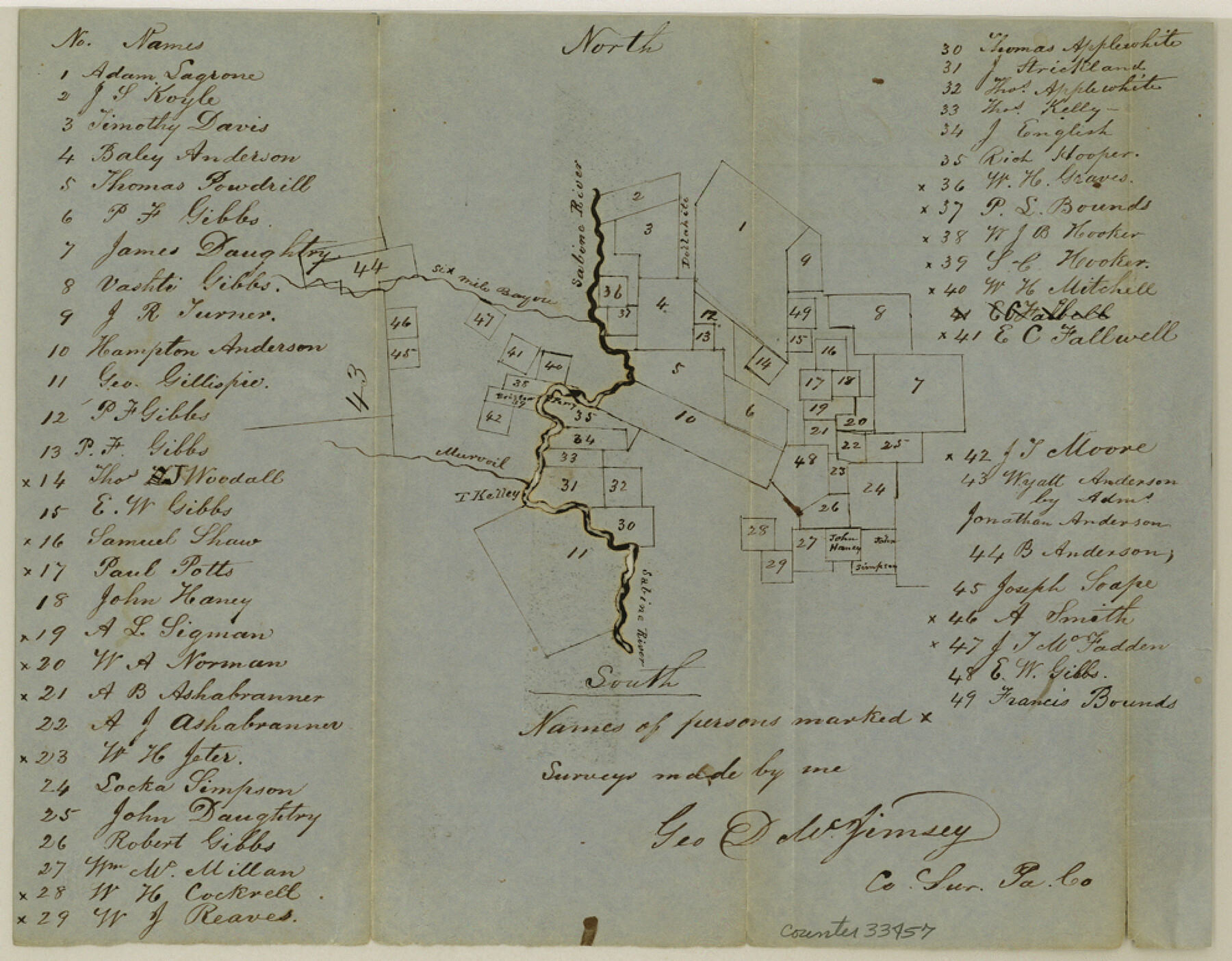
Panola County Sketch File 7
[Sketch east of Carthage along Sabine River]
-
Map/Doc
33457
-
Collection
General Map Collection
-
Object Dates
11/4/1862 (File Date)
-
People and Organizations
George D. McJimsey (Surveyor/Engineer)
-
Counties
Panola
-
Subjects
Surveying Sketch File
-
Height x Width
7.7 x 9.9 inches
19.6 x 25.2 cm
-
Medium
paper, manuscript
-
Features
Six Mile Bayou
Sabine River
Murvoil Creek
Part of: General Map Collection
McMullen County Sketch File 24

Print $22.00
- Digital $50.00
McMullen County Sketch File 24
Size 8.7 x 12.6 inches
Map/Doc 31381
Deaf Smith County Working Sketch 1

Print $20.00
- Digital $50.00
Deaf Smith County Working Sketch 1
1919
Size 27.3 x 14.7 inches
Map/Doc 68641
Travis County Sketch File 12

Print $4.00
- Digital $50.00
Travis County Sketch File 12
1850
Size 12.7 x 8.2 inches
Map/Doc 38304
Andrews County

Print $40.00
- Digital $50.00
Andrews County
1901
Size 42.5 x 55.2 inches
Map/Doc 4779
Collin County

Print $20.00
- Digital $50.00
Collin County
1975
Size 42.2 x 39.4 inches
Map/Doc 77242
Panola County Working Sketch 8

Print $20.00
- Digital $50.00
Panola County Working Sketch 8
1943
Map/Doc 71417
Flight Mission No. DCL-7C, Frame 18, Kenedy County

Print $20.00
- Digital $50.00
Flight Mission No. DCL-7C, Frame 18, Kenedy County
1943
Size 15.4 x 15.2 inches
Map/Doc 86010

Travis County Sketch File 34

Print $26.00
- Digital $50.00
Travis County Sketch File 34
1888
Size 26.8 x 27.9 inches
Map/Doc 12461
Visitor's Guide to Mexico City, D.F. [and Index to Cities and Villages and Route Summaries]
![96822, Visitor's Guide to Mexico City, D.F. [and Index to Cities and Villages and Route Summaries], General Map Collection](https://historictexasmaps.com/wmedia_w700/maps/96822.tif.jpg)
Visitor's Guide to Mexico City, D.F. [and Index to Cities and Villages and Route Summaries]
1999
Size 33.7 x 25.1 inches
Map/Doc 96822
Freestone County Working Sketch 11

Print $40.00
- Digital $50.00
Freestone County Working Sketch 11
1978
Size 31.4 x 51.4 inches
Map/Doc 69253
Flight Mission No. BRE-2P, Frame 69, Nueces County

Print $20.00
- Digital $50.00
Flight Mission No. BRE-2P, Frame 69, Nueces County
1956
Size 18.6 x 22.5 inches
Map/Doc 86764
You may also like
Harris County

Print $20.00
- Digital $50.00
Harris County
1940
Size 37.7 x 46.4 inches
Map/Doc 95522
Montgomery County Working Sketch 14

Print $20.00
- Digital $50.00
Montgomery County Working Sketch 14
1934
Size 18.5 x 20.1 inches
Map/Doc 71121
Map of Leon County

Print $40.00
- Digital $50.00
Map of Leon County
Size 49.7 x 42.0 inches
Map/Doc 66900
Zavala County Working Sketch 22

Print $40.00
- Digital $50.00
Zavala County Working Sketch 22
1980
Size 70.4 x 43.5 inches
Map/Doc 62097
Edwards County Working Sketch 36

Print $20.00
- Digital $50.00
Edwards County Working Sketch 36
1948
Size 46.7 x 44.5 inches
Map/Doc 68912

Coast Chart No. 211 - Padre I. and Laguna Madre Lat. 27° 12' to Lat. 26° 33' Texas

Print $20.00
- Digital $50.00
Coast Chart No. 211 - Padre I. and Laguna Madre Lat. 27° 12' to Lat. 26° 33' Texas
1890
Size 27.2 x 18.2 inches
Map/Doc 72821
Gaines County Working Sketch 18

Print $20.00
- Digital $50.00
Gaines County Working Sketch 18
1970
Size 25.4 x 44.5 inches
Map/Doc 69318
Crosby County Working Sketch 7

Print $20.00
- Digital $50.00
Crosby County Working Sketch 7
1938
Size 33.8 x 21.6 inches
Map/Doc 68441
Llano County Sketch File 10

Print $10.00
- Digital $50.00
Llano County Sketch File 10
1886
Size 8.2 x 7.6 inches
Map/Doc 30370
Calhoun County Rolled Sketch 12

Print $40.00
- Digital $50.00
Calhoun County Rolled Sketch 12
1940
Size 30.2 x 54.8 inches
Map/Doc 43619
Dimmit County Working Sketch 26

Print $20.00
- Digital $50.00
Dimmit County Working Sketch 26
1956
Size 19.3 x 15.9 inches
Map/Doc 68687