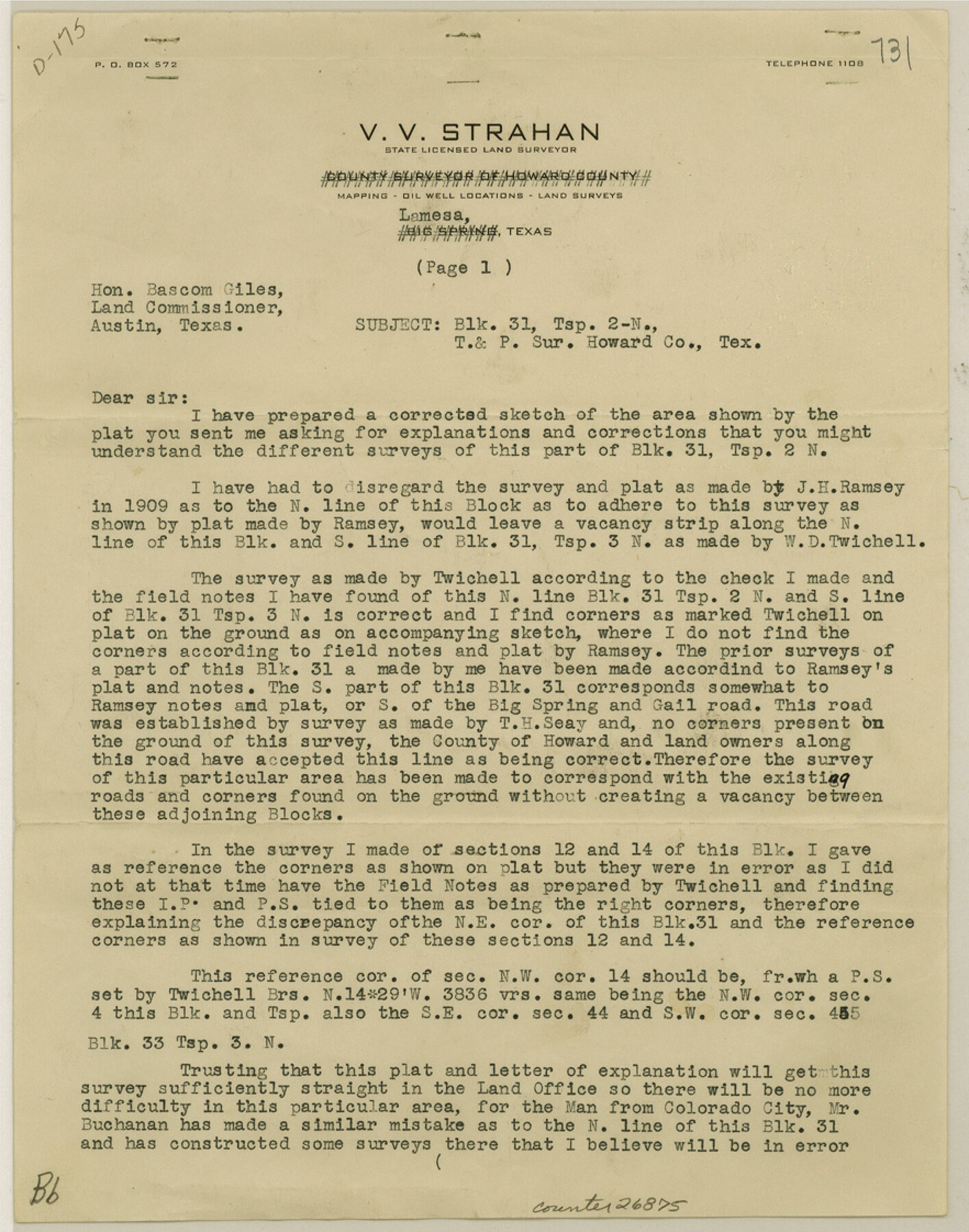
Howard County Sketch File 15
[Statement from V. V. Strahan regarding construction of the north part of T. & P. Block 31, Township 2N]
-
Map/Doc
26875
-
Collection
General Map Collection
-
Object Dates
4/30/1941 (File Date)
1909 (Survey Date)
-
People and Organizations
V.V. Strahan (Surveyor/Engineer)
J.H. Ramsey (Surveyor/Engineer)
W.D. Twichell (Surveyor/Engineer)
T.H. Seay (Surveyor/Engineer)
Mr. Buchanan (Surveyor/Engineer)
-
Counties
Howard
-
Subjects
Surveying Sketch File
-
Height x Width
11.2 x 8.8 inches
28.5 x 22.4 cm
-
Medium
paper, print
-
Features
Big Spring and Gail Road
Part of: General Map Collection
Leon River, Magnum Sheet/South Fork Leon River

Print $6.00
- Digital $50.00
Leon River, Magnum Sheet/South Fork Leon River
1937
Size 30.5 x 34.8 inches
Map/Doc 65068
Cameron County Sketch File 7a

Print $32.00
- Digital $50.00
Cameron County Sketch File 7a
1982
Size 11.2 x 8.4 inches
Map/Doc 17115
Fort Bend County Sketch File 18 1/2

Print $20.00
- Digital $50.00
Fort Bend County Sketch File 18 1/2
1896
Size 18.3 x 15.3 inches
Map/Doc 11508
Andrews County Working Sketch 13

Print $20.00
- Digital $50.00
Andrews County Working Sketch 13
1956
Size 37.3 x 30.6 inches
Map/Doc 67059
Copy of Surveyor's Field Book, Morris Browning - In Blocks 7, 5 & 4, I&GNRRCo., Hutchinson and Carson Counties, Texas

Print $2.00
- Digital $50.00
Copy of Surveyor's Field Book, Morris Browning - In Blocks 7, 5 & 4, I&GNRRCo., Hutchinson and Carson Counties, Texas
1888
Size 7.0 x 8.8 inches
Map/Doc 62276
Maps of Gulf Intracoastal Waterway, Texas - Sabine River to the Rio Grande and connecting waterways including ship channels

Print $20.00
- Digital $50.00
Maps of Gulf Intracoastal Waterway, Texas - Sabine River to the Rio Grande and connecting waterways including ship channels
1966
Size 14.2 x 20.1 inches
Map/Doc 61990
Map of Bryan, Brazos County, Texas

Print $20.00
- Digital $50.00
Map of Bryan, Brazos County, Texas
1915
Size 18.5 x 24.6 inches
Map/Doc 3210
Harris County Working Sketch 31

Print $20.00
- Digital $50.00
Harris County Working Sketch 31
1936
Size 27.7 x 22.0 inches
Map/Doc 65923
Map of Deaf Smith Co.

Print $40.00
- Digital $50.00
Map of Deaf Smith Co.
1898
Size 42.5 x 54.6 inches
Map/Doc 16821
Nueces County Sketch File 41

Print $8.00
- Digital $50.00
Nueces County Sketch File 41
Size 11.1 x 8.6 inches
Map/Doc 32629
Sabine County Working Sketch 16

Print $20.00
- Digital $50.00
Sabine County Working Sketch 16
1984
Size 26.0 x 29.8 inches
Map/Doc 63687

You may also like
Ft. W. & R. G. Ry. Right of Way Map, Chapin to Bluffdale, Hood County, Texas

Print $40.00
- Digital $50.00
Ft. W. & R. G. Ry. Right of Way Map, Chapin to Bluffdale, Hood County, Texas
1918
Size 37.3 x 120.2 inches
Map/Doc 64642
Navigation Maps of Gulf Intracoastal Waterway, Port Arthur to Brownsville, Texas

Print $4.00
- Digital $50.00
Navigation Maps of Gulf Intracoastal Waterway, Port Arthur to Brownsville, Texas
1951
Size 16.7 x 21.2 inches
Map/Doc 65449
Erath County Rolled Sketch 5

Print $20.00
- Digital $50.00
Erath County Rolled Sketch 5
Size 31.2 x 39.5 inches
Map/Doc 8883
Map of Jefferson County

Print $20.00
- Digital $50.00
Map of Jefferson County
1896
Size 26.7 x 23.2 inches
Map/Doc 66883
Travis County Appraisal District Plat Map 2_2813

Print $20.00
- Digital $50.00
Travis County Appraisal District Plat Map 2_2813
Size 21.5 x 26.5 inches
Map/Doc 94217
Jones County Working Sketch 10

Print $20.00
- Digital $50.00
Jones County Working Sketch 10
1982
Size 19.3 x 34.3 inches
Map/Doc 66648
Maps & Lists Showing Prison Lands (Oil & Gas) Leased as of June 1955

Digital $50.00
Maps & Lists Showing Prison Lands (Oil & Gas) Leased as of June 1955
Size 11.1 x 9.0 inches
Map/Doc 62872
[County Line between DeWitt and Lavaca Counties]
![65355, [County Line between DeWitt and Lavaca Counties], General Map Collection](https://historictexasmaps.com/wmedia_w700/pdf_converted_jpg/qi_pdf_thumbnail_19782.jpg)
Print $226.00
- Digital $50.00
[County Line between DeWitt and Lavaca Counties]
1906
Size 17.4 x 34.4 inches
Map/Doc 65355
Harris County Working Sketch 76

Print $20.00
- Digital $50.00
Harris County Working Sketch 76
1966
Size 32.2 x 24.2 inches
Map/Doc 65968
Brazos River Conservation and Reclamation District Official Boundary Line Survey

Print $20.00
- Digital $50.00
Brazos River Conservation and Reclamation District Official Boundary Line Survey
Size 25.0 x 37.0 inches
Map/Doc 90182
Gaines County Working Sketch 27

Print $20.00
- Digital $50.00
Gaines County Working Sketch 27
Size 17.4 x 36.7 inches
Map/Doc 69327
Bauer & Cockrell Lands Located in Martin County, Texas

Print $20.00
- Digital $50.00
Bauer & Cockrell Lands Located in Martin County, Texas
1908
Size 28.5 x 22.3 inches
Map/Doc 91365