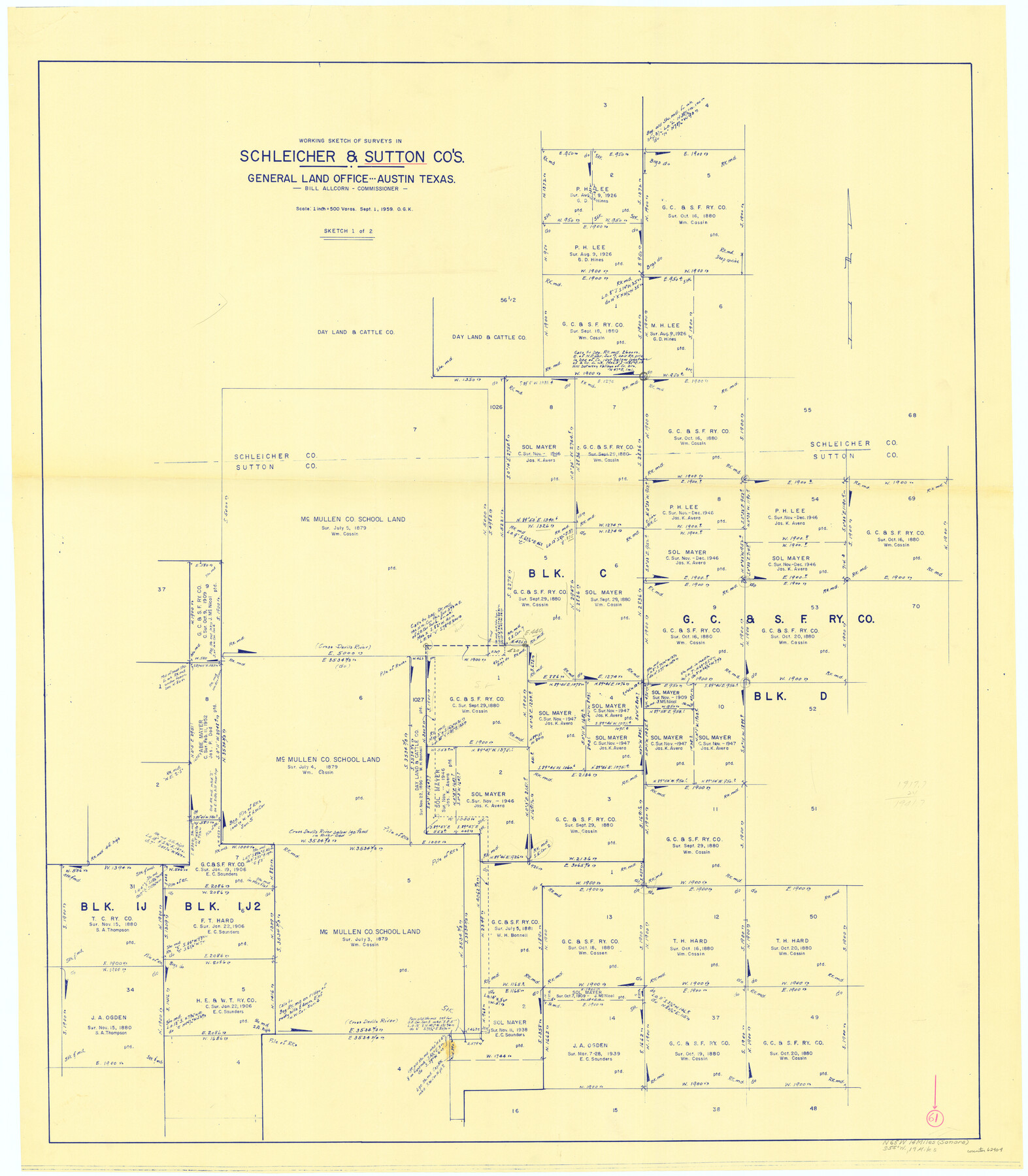
Sutton County Working Sketch 61
-
Map/Doc
62404
-
Collection
General Map Collection
-
Object Dates
9/1/1959 (Creation Date)
-
People and Organizations
Otto G. Kurio (Draftsman)
-
Counties
Sutton Schleicher
-
Subjects
Surveying Working Sketch
-
Height x Width
44.1 x 38.6 inches
112.0 x 98.0 cm
-
Scale
1" = 500 varas
Part of: General Map Collection
Harrison County Sketch File 23

Print $125.00
- Digital $50.00
Harrison County Sketch File 23
Size 10.6 x 12.2 inches
Map/Doc 26061
Falls County Sketch File 28

Print $2.00
- Digital $50.00
Falls County Sketch File 28
Size 7.7 x 10.3 inches
Map/Doc 22438
Newton County Working Sketch 31

Print $20.00
- Digital $50.00
Newton County Working Sketch 31
1955
Size 34.3 x 43.6 inches
Map/Doc 71277
Angelina County Sketch File 17

Print $9.00
- Digital $50.00
Angelina County Sketch File 17
1863
Size 8.2 x 7.0 inches
Map/Doc 13020
Liberty County Rolled Sketch I

Print $20.00
- Digital $50.00
Liberty County Rolled Sketch I
1944
Size 38.1 x 38.1 inches
Map/Doc 10642
Texas showing Counties, Cities, Towns, Railroads and Water-courses. Completely indexed, showing locations with latest census population figures.

Print $20.00
- Digital $50.00
Texas showing Counties, Cities, Towns, Railroads and Water-courses. Completely indexed, showing locations with latest census population figures.
1950
Size 32.0 x 28.5 inches
Map/Doc 97097
Collingsworth County Working Sketch Graphic Index

Print $20.00
- Digital $50.00
Collingsworth County Working Sketch Graphic Index
1971
Size 41.0 x 34.8 inches
Map/Doc 76499
Hansford County

Print $20.00
- Digital $50.00
Hansford County
1902
Size 42.3 x 37.5 inches
Map/Doc 4969
Crane County Rolled Sketch 19

Print $20.00
- Digital $50.00
Crane County Rolled Sketch 19
1926
Size 26.4 x 28.3 inches
Map/Doc 5577
Presidio County Sketch File 76

Print $20.00
- Digital $50.00
Presidio County Sketch File 76
Size 22.0 x 18.3 inches
Map/Doc 11720
Parker County Rolled Sketch 5

Print $20.00
- Digital $50.00
Parker County Rolled Sketch 5
1987
Size 21.9 x 21.4 inches
Map/Doc 7206
Robertson County Working Sketch 7

Print $20.00
- Digital $50.00
Robertson County Working Sketch 7
1983
Size 36.6 x 38.3 inches
Map/Doc 78228
You may also like
Colorado County Boundary File 2

Print $8.00
- Digital $50.00
Colorado County Boundary File 2
Size 14.3 x 8.7 inches
Map/Doc 51772
Crockett County Working Sketch Graphic Index - northeast part

Print $20.00
- Digital $50.00
Crockett County Working Sketch Graphic Index - northeast part
1976
Size 35.6 x 46.4 inches
Map/Doc 76511
Edwards County Rolled Sketch 17

Print $20.00
- Digital $50.00
Edwards County Rolled Sketch 17
1945
Size 27.6 x 19.4 inches
Map/Doc 5806
Smith County Rolled Sketch 8

Print $20.00
- Digital $50.00
Smith County Rolled Sketch 8
2006
Size 24.7 x 37.0 inches
Map/Doc 95411
Williamson County Rolled Sketch 5

Print $20.00
- Digital $50.00
Williamson County Rolled Sketch 5
1940
Size 23.7 x 34.5 inches
Map/Doc 8263
Travis County

Print $40.00
- Digital $50.00
Travis County
1880
Size 61.7 x 24.0 inches
Map/Doc 87934
J No. 5 - Reconnaissance of San Pedro Harbor, California

Print $20.00
- Digital $50.00
J No. 5 - Reconnaissance of San Pedro Harbor, California
1852
Size 12.3 x 15.5 inches
Map/Doc 97232
Flight Mission No. DCL-7C, Frame 38, Kenedy County

Print $20.00
- Digital $50.00
Flight Mission No. DCL-7C, Frame 38, Kenedy County
1943
Size 15.4 x 15.1 inches
Map/Doc 86026
Jefferson County Sketch File 20

Print $40.00
- Digital $50.00
Jefferson County Sketch File 20
1872
Size 12.3 x 15.0 inches
Map/Doc 28169
Dickens County Sketch File M

Print $59.00
- Digital $50.00
Dickens County Sketch File M
1908
Size 14.6 x 9.1 inches
Map/Doc 20911
Flight Mission No. CUG-1P, Frame 163, Kleberg County

Print $20.00
- Digital $50.00
Flight Mission No. CUG-1P, Frame 163, Kleberg County
1956
Size 18.6 x 22.2 inches
Map/Doc 86170
Jefferson County Sketch File 47

Print $20.00
- Digital $50.00
Jefferson County Sketch File 47
1898
Size 27.2 x 19.1 inches
Map/Doc 11881