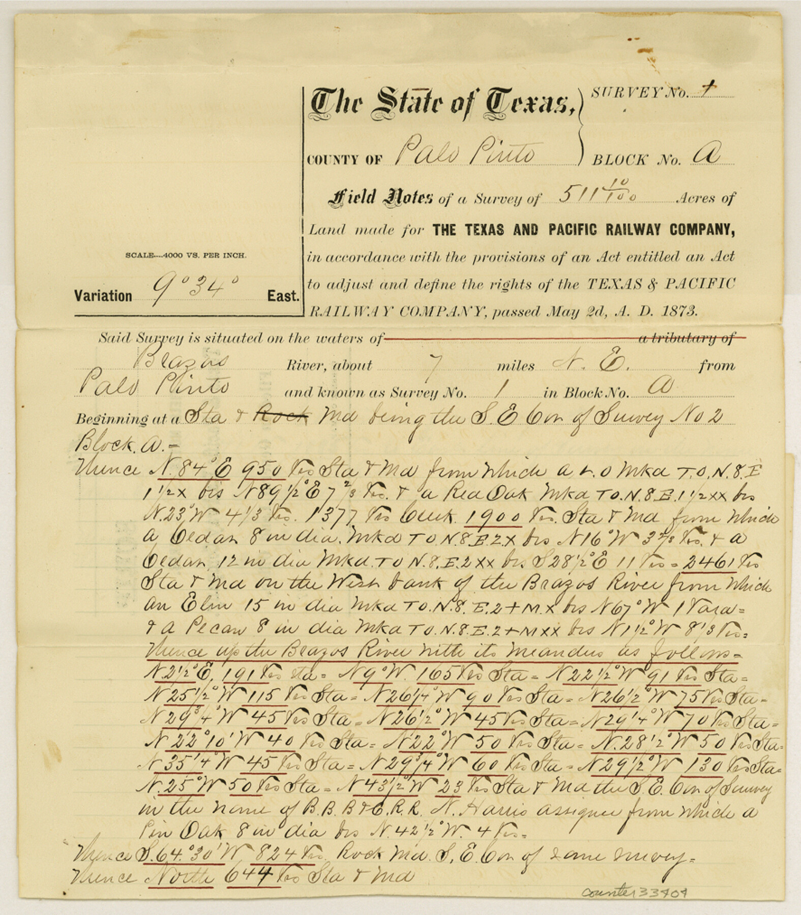
Palo Pinto County Sketch File 25
[Field notes of multiple T. & P. RR. Co. surveys]
-
Map/Doc
33404
-
Collection
General Map Collection
-
Object Dates
6/1874 (Creation Date)
12/3/1984 (File Date)
4/22/1874 (Survey Date)
5/17/1874 (Survey Date)
6/1/1874 (Survey Date)
4/27/1874 (Survey Date)
-
People and Organizations
William B. Champlin (Surveyor/Engineer)
J.H. Reid (Chainman/Field Personnel)
William B. Riley (Chainman/Field Personnel)
P. Tumblety (Chainman/Field Personnel)
A.D. Lewis (Chainman/Field Personnel)
Charles H. Irwin (Surveyor/Engineer)
-
Counties
Palo Pinto
-
Subjects
Surveying Sketch File
-
Height x Width
10.1 x 8.9 inches
25.7 x 22.6 cm
-
Medium
paper, print with manuscript additions
-
Features
Brazos River
Iona Creek
Eagle Creek
Part of: General Map Collection
Flight Mission No. CRK-5P, Frame 128, Refugio County

Print $20.00
- Digital $50.00
Flight Mission No. CRK-5P, Frame 128, Refugio County
1956
Size 18.6 x 22.5 inches
Map/Doc 86931
Chambers County Sketch File 4a

Print $19.00
- Digital $50.00
Chambers County Sketch File 4a
1839
Size 11.4 x 17.8 inches
Map/Doc 17523
Coryell County

Print $20.00
- Digital $50.00
Coryell County
1936
Size 45.4 x 41.4 inches
Map/Doc 95466
Flight Mission No. BRA-7M, Frame 31, Jefferson County

Print $20.00
- Digital $50.00
Flight Mission No. BRA-7M, Frame 31, Jefferson County
1953
Size 18.5 x 22.3 inches
Map/Doc 85482
Andrews County Working Sketch 29

Print $20.00
- Digital $50.00
Andrews County Working Sketch 29
1988
Size 25.9 x 25.8 inches
Map/Doc 67075
Flight Mission No. DQO-6K, Frame 20, Galveston County

Print $20.00
- Digital $50.00
Flight Mission No. DQO-6K, Frame 20, Galveston County
1952
Size 18.8 x 22.3 inches
Map/Doc 85093
Presidio County Sketch File 41

Print $6.00
- Digital $50.00
Presidio County Sketch File 41
Size 10.3 x 8.3 inches
Map/Doc 34515
McMullen County Working Sketch 37

Print $20.00
- Digital $50.00
McMullen County Working Sketch 37
1969
Size 37.4 x 38.4 inches
Map/Doc 70738
Live Oak County Working Sketch 20

Print $20.00
- Digital $50.00
Live Oak County Working Sketch 20
1962
Size 29.7 x 35.7 inches
Map/Doc 70605
Childress County Rolled Sketch 9

Print $20.00
- Digital $50.00
Childress County Rolled Sketch 9
Size 19.3 x 22.9 inches
Map/Doc 5446
Red River County Working Sketch 23

Print $20.00
- Digital $50.00
Red River County Working Sketch 23
1958
Size 30.7 x 26.1 inches
Map/Doc 72006
Atascosa County Sketch File 3

Print $14.00
- Digital $50.00
Atascosa County Sketch File 3
1854
Size 9.1 x 8.6 inches
Map/Doc 13730
You may also like
[Surveys along Cypress Creek]
![155, [Surveys along Cypress Creek], General Map Collection](https://historictexasmaps.com/wmedia_w700/maps/155.tif.jpg)
Print $2.00
- Digital $50.00
[Surveys along Cypress Creek]
1844
Size 6.0 x 6.1 inches
Map/Doc 155
Dickens County

Print $20.00
- Digital $50.00
Dickens County
1877
Size 19.1 x 18.4 inches
Map/Doc 3486
Baylor County Sketch File 12g

Print $50.00
- Digital $50.00
Baylor County Sketch File 12g
Size 11.4 x 8.9 inches
Map/Doc 14170
Ward County Rolled Sketch PMY

Print $40.00
- Digital $50.00
Ward County Rolled Sketch PMY
1935
Size 14.4 x 74.5 inches
Map/Doc 10104
Duval County Sketch File 71

Print $4.00
- Digital $50.00
Duval County Sketch File 71
1953
Size 15.2 x 9.0 inches
Map/Doc 21458
Rains County Boundary File 71

Print $6.00
- Digital $50.00
Rains County Boundary File 71
Size 8.7 x 3.5 inches
Map/Doc 58094
Brown County Sketch File 19

Print $8.00
- Digital $50.00
Brown County Sketch File 19
1873
Size 12.8 x 8.2 inches
Map/Doc 16616
General Highway Map, Live Oak County, Texas

Print $20.00
General Highway Map, Live Oak County, Texas
1961
Size 18.3 x 24.8 inches
Map/Doc 79575
Gray County Boundary File 11

Print $80.00
- Digital $50.00
Gray County Boundary File 11
Size 20.7 x 19.7 inches
Map/Doc 53912
Mapa Geográphico de la Provincia de Tejas

Mapa Geográphico de la Provincia de Tejas
1822
Size 9.8 x 12.7 inches
Map/Doc 94457
Portion of States Submerged Area in Matagorda Bay

Print $20.00
- Digital $50.00
Portion of States Submerged Area in Matagorda Bay
1922
Size 15.2 x 14.8 inches
Map/Doc 2953
The Judicial District/County of Pashcal. June 24, 1841

Print $20.00
The Judicial District/County of Pashcal. June 24, 1841
2020
Size 15.0 x 21.7 inches
Map/Doc 96344