Presidio County Sketch File 41
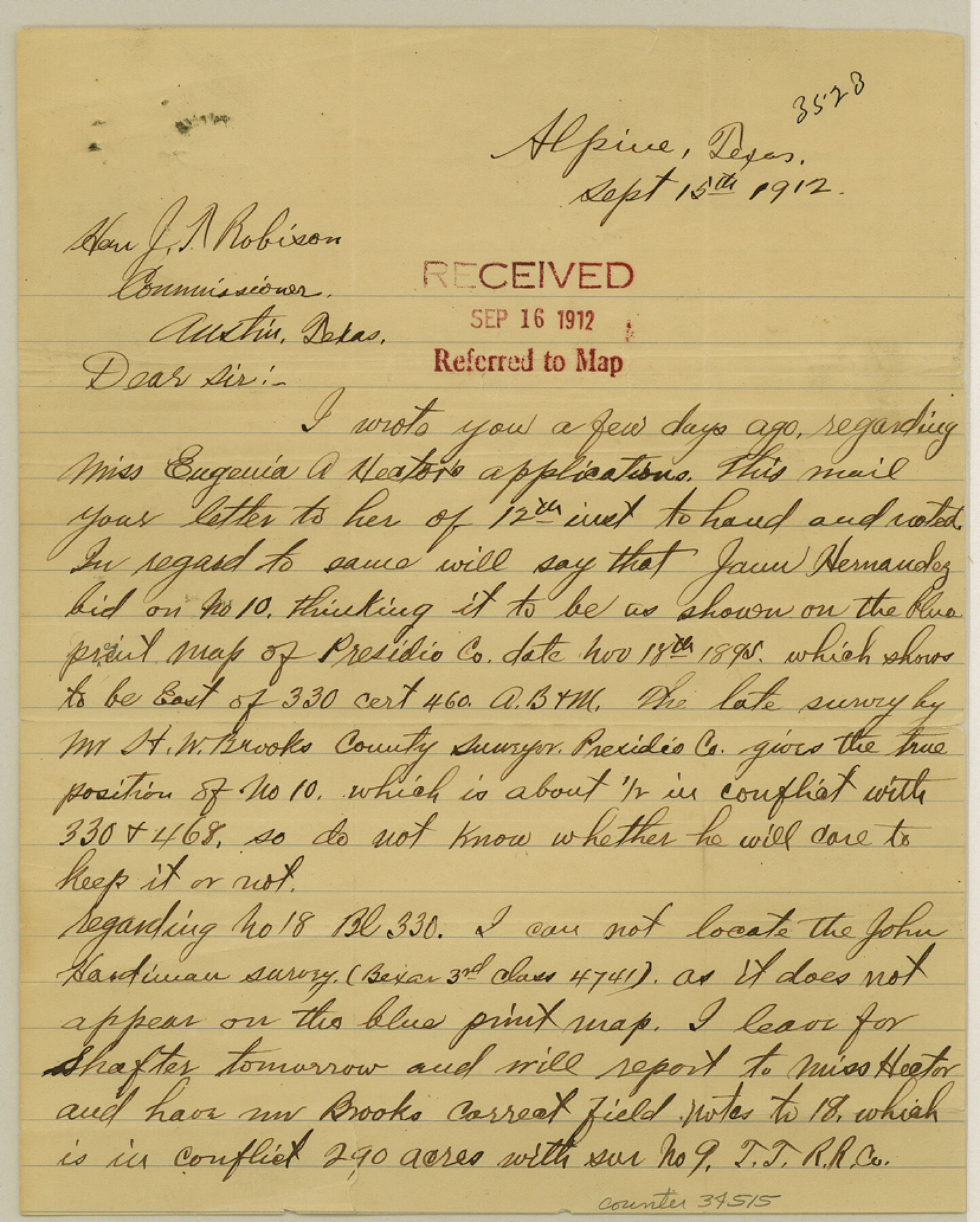
[Letter of explanation regarding different positions of surveys]
-
Map/Doc
34515
-
Collection
General Map Collection
-
Object Dates
9/16/1912 (File Date)
9/15/1912 (Correspondence Date)
-
People and Organizations
O.H. Hector (Surveyor/Engineer)
H.W. Brooks (Surveyor/Engineer)
-
Counties
Presidio
-
Subjects
Surveying Sketch File
-
Height x Width
10.3 x 8.3 inches
26.2 x 21.1 cm
-
Medium
paper, manuscript
-
Features
Shaafter
Part of: General Map Collection
Uvalde County Sketch File 4

Print $22.00
- Digital $50.00
Uvalde County Sketch File 4
1879
Size 12.8 x 8.3 inches
Map/Doc 38951
Flight Mission No. CGN-3P, Frame 22, San Patricio County

Print $20.00
- Digital $50.00
Flight Mission No. CGN-3P, Frame 22, San Patricio County
1956
Size 18.6 x 22.3 inches
Map/Doc 86980
Leon County Boundary File 1

Print $34.00
- Digital $50.00
Leon County Boundary File 1
Size 21.0 x 6.6 inches
Map/Doc 56281
Leon County Working Sketch 2

Print $20.00
- Digital $50.00
Leon County Working Sketch 2
Size 17.3 x 17.0 inches
Map/Doc 70401
Shelby County Sketch File 21

Print $2.00
- Digital $50.00
Shelby County Sketch File 21
Size 8.9 x 4.0 inches
Map/Doc 36642
Montague County Working Sketch 29

Print $20.00
- Digital $50.00
Montague County Working Sketch 29
1972
Size 27.8 x 22.1 inches
Map/Doc 71095
Presidio County Working Sketch 92

Print $20.00
- Digital $50.00
Presidio County Working Sketch 92
1976
Size 27.1 x 23.1 inches
Map/Doc 71769
Andrews County Working Sketch 8

Print $20.00
- Digital $50.00
Andrews County Working Sketch 8
1954
Size 18.2 x 14.9 inches
Map/Doc 67054
Flight Mission No. DQN-2K, Frame 26, Calhoun County

Print $20.00
- Digital $50.00
Flight Mission No. DQN-2K, Frame 26, Calhoun County
1953
Size 18.6 x 22.2 inches
Map/Doc 84233
Palo Pinto County

Print $20.00
- Digital $50.00
Palo Pinto County
1879
Size 24.8 x 18.4 inches
Map/Doc 3934
Wharton County Working Sketch 25

Print $20.00
- Digital $50.00
Wharton County Working Sketch 25
1993
Size 20.0 x 25.5 inches
Map/Doc 72489
Dallam County Sketch File 2

Print $260.00
- Digital $50.00
Dallam County Sketch File 2
1886
Size 29.9 x 17.4 inches
Map/Doc 11278
You may also like
Amistad International Reservoir on Rio Grande 64

Print $20.00
- Digital $50.00
Amistad International Reservoir on Rio Grande 64
1949
Size 28.4 x 39.6 inches
Map/Doc 73349
General Highway Map, Armstrong County, Texas

Print $20.00
General Highway Map, Armstrong County, Texas
1961
Size 18.3 x 25.0 inches
Map/Doc 79354
Current Miscellaneous File 9

Print $66.00
- Digital $50.00
Current Miscellaneous File 9
Size 6.5 x 8.2 inches
Map/Doc 73741
Mitchell County Sketch File 8

Print $20.00
- Digital $50.00
Mitchell County Sketch File 8
1909
Size 26.9 x 20.9 inches
Map/Doc 12098
Galveston County NRC Article 33.136 Sketch 65

Print $28.00
- Digital $50.00
Galveston County NRC Article 33.136 Sketch 65
2012
Size 24.0 x 36.0 inches
Map/Doc 93328
Chambers County Working Sketch 27

Print $20.00
- Digital $50.00
Chambers County Working Sketch 27
1982
Size 24.9 x 25.2 inches
Map/Doc 68010
Palo Pinto County Sketch File 2

Print $4.00
- Digital $50.00
Palo Pinto County Sketch File 2
1857
Size 8.2 x 10.3 inches
Map/Doc 33392
Eastland County Working Sketch 18

Print $20.00
- Digital $50.00
Eastland County Working Sketch 18
1919
Size 15.9 x 15.7 inches
Map/Doc 68799
Starr County Rolled Sketch 42

Print $20.00
- Digital $50.00
Starr County Rolled Sketch 42
1972
Size 26.0 x 18.4 inches
Map/Doc 7835
Andrews County

Print $40.00
- Digital $50.00
Andrews County
1925
Size 42.6 x 57.1 inches
Map/Doc 66703
Goliad County Working Sketch 9

Print $20.00
- Digital $50.00
Goliad County Working Sketch 9
1938
Size 19.3 x 27.6 inches
Map/Doc 63199
Sterling County Working Sketch 6

Print $40.00
- Digital $50.00
Sterling County Working Sketch 6
1955
Size 38.1 x 121.6 inches
Map/Doc 63988