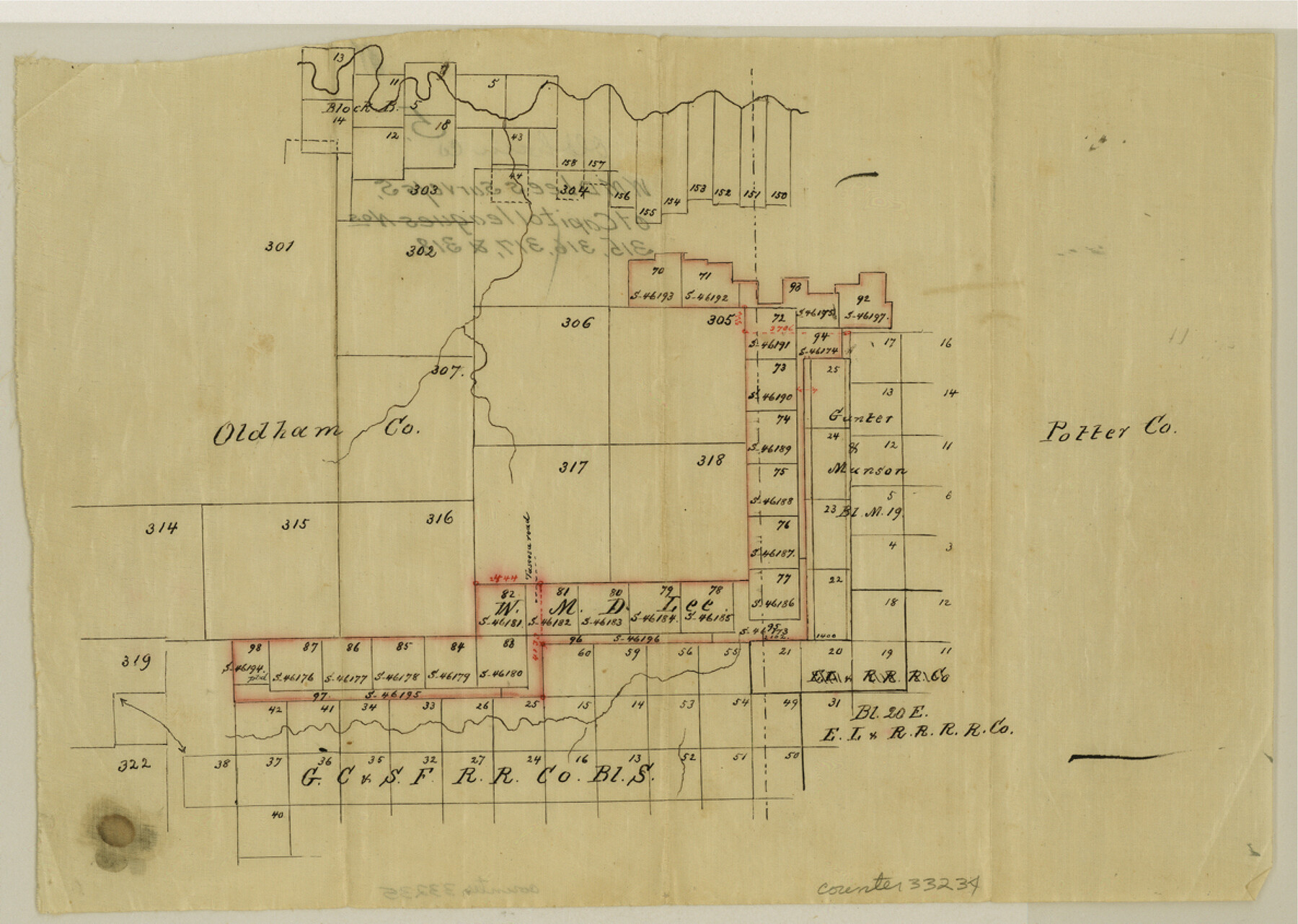
Oldham County Sketch File 5
[Sketch of surveys south and east of Capitol Leagues 315, 316, 317, 318, and 305]
-
Map/Doc
33234
-
Collection
General Map Collection
-
People and Organizations
W.M.D. Lee (Surveyor/Engineer)
-
Counties
Oldham Potter
-
Subjects
Surveying Sketch File
-
Height x Width
8.5 x 11.9 inches
21.6 x 30.2 cm
-
Medium
paper, manuscript
Part of: General Map Collection

Pecos County Working Sketch 40

Print $20.00
- Digital $50.00
Pecos County Working Sketch 40
1941
Size 29.9 x 39.7 inches
Map/Doc 71512
Dallam County Sketch File 5

Print $22.00
- Digital $50.00
Dallam County Sketch File 5
1880
Size 14.2 x 8.8 inches
Map/Doc 20339
Coleman County Working Sketch 20

Print $20.00
- Digital $50.00
Coleman County Working Sketch 20
1953
Size 32.7 x 41.9 inches
Map/Doc 68086
Hutchinson County Rolled Sketch 43

Print $40.00
- Digital $50.00
Hutchinson County Rolled Sketch 43
1992
Size 41.3 x 50.0 inches
Map/Doc 6314
Pecos County Working Sketch 89.5

Print $40.00
- Digital $50.00
Pecos County Working Sketch 89.5
1965
Size 80.5 x 32.5 inches
Map/Doc 71561
Map of San Saba County

Print $20.00
- Digital $50.00
Map of San Saba County
1858
Size 21.6 x 23.5 inches
Map/Doc 4019
Zavala County Sketch File B

Print $34.00
- Digital $50.00
Zavala County Sketch File B
1908
Size 13.5 x 8.9 inches
Map/Doc 41364
Leon County Working Sketch 15

Print $20.00
- Digital $50.00
Leon County Working Sketch 15
1958
Size 27.3 x 26.7 inches
Map/Doc 70414
Harrison County Sketch File 14

Print $32.00
- Digital $50.00
Harrison County Sketch File 14
1880
Size 11.2 x 8.8 inches
Map/Doc 26053
Starr County Rolled Sketch 29

Print $20.00
- Digital $50.00
Starr County Rolled Sketch 29
1857
Size 35.1 x 30.0 inches
Map/Doc 7812
Kinney County Working Sketch 47

Print $20.00
- Digital $50.00
Kinney County Working Sketch 47
1979
Size 40.5 x 39.1 inches
Map/Doc 70229
You may also like
Right of Way & Track Map, St. Louis, Brownsville & Mexico Ry. operated by St. Louis, Brownsville & Mexico Ry. Co.

Print $40.00
- Digital $50.00
Right of Way & Track Map, St. Louis, Brownsville & Mexico Ry. operated by St. Louis, Brownsville & Mexico Ry. Co.
1919
Size 25.4 x 57.2 inches
Map/Doc 64621
Falls County Sketch File 1

Print $4.00
- Digital $50.00
Falls County Sketch File 1
1852
Size 10.7 x 8.6 inches
Map/Doc 22330
Map of Eastland Co.

Print $20.00
- Digital $50.00
Map of Eastland Co.
1896
Size 43.2 x 43.1 inches
Map/Doc 78410
La Salle County Working Sketch 30

Print $20.00
- Digital $50.00
La Salle County Working Sketch 30
1955
Size 34.6 x 28.9 inches
Map/Doc 70331
Bee County Working Sketch 15

Print $20.00
- Digital $50.00
Bee County Working Sketch 15
1974
Size 20.4 x 27.9 inches
Map/Doc 67265
Travis County Working Sketch 36

Print $20.00
- Digital $50.00
Travis County Working Sketch 36
1967
Size 23.4 x 30.8 inches
Map/Doc 69420
Map of Williamson County

Print $20.00
- Digital $50.00
Map of Williamson County
1880
Size 20.9 x 29.0 inches
Map/Doc 4148
Sherman County Rolled Sketch 6

Print $20.00
- Digital $50.00
Sherman County Rolled Sketch 6
1919
Size 37.3 x 36.0 inches
Map/Doc 10731
Township 4 South Ranges 12 and 13 West, South Western District, Louisiana

Print $20.00
- Digital $50.00
Township 4 South Ranges 12 and 13 West, South Western District, Louisiana
1857
Size 18.6 x 24.2 inches
Map/Doc 65891
Falls County Working Sketch 4

Print $20.00
- Digital $50.00
Falls County Working Sketch 4
1943
Size 24.3 x 22.0 inches
Map/Doc 69179
Sabine and Neches Rivers

Print $20.00
- Digital $50.00
Sabine and Neches Rivers
1971
Size 19.7 x 44.4 inches
Map/Doc 69817
Hudspeth County Sketch File 38

Print $20.00
- Digital $50.00
Hudspeth County Sketch File 38
Size 27.5 x 24.1 inches
Map/Doc 11806