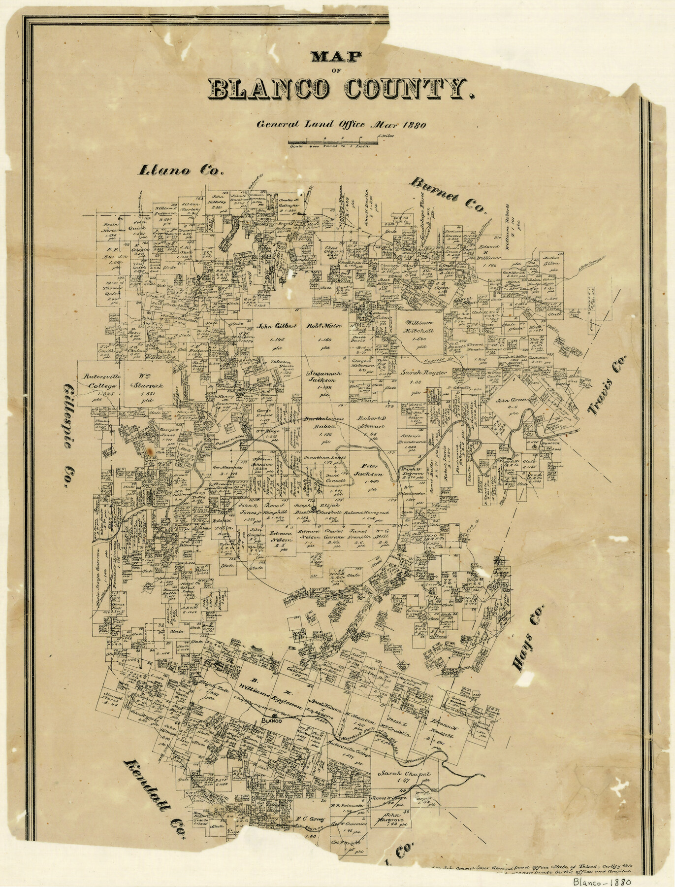
Map of Blanco County
-
Map/Doc
3306
-
Collection
General Map Collection
-
Object Dates
3/1880 (Creation Date)
-
Counties
Blanco
-
Subjects
County
-
Height x Width
23.9 x 18.2 inches
60.7 x 46.2 cm
-
Features
Spring Creek
Rio Blanco
Webb Creek
Martin's Fork of the Rio Blanco
Blanco
Onion Creek
Yager Creek
William's Creek
Rock Creek
Flat Creek
Rio Pedernales
Grape Creek
Shovel Mountains
Fall Creek
Cypress Creek
Little Cypress Creek
Double Horn Creek
Flat Rock Creek
Slick Rock Creek
Pecan Creek
Walnut Creek
Comanche Creek
Miller's Creek
Part of: General Map Collection

Hidalgo County Sketch File 2

Print $14.00
- Digital $50.00
Hidalgo County Sketch File 2
1877
Size 10.1 x 8.1 inches
Map/Doc 26394
Callahan County Boundary File 1a

Print $4.00
- Digital $50.00
Callahan County Boundary File 1a
Size 13.3 x 8.7 inches
Map/Doc 51085
Encinal County

Print $20.00
- Digital $50.00
Encinal County
1886
Size 32.2 x 23.6 inches
Map/Doc 3518
Foard County Aerial Photograph Index Sheet 4

Print $20.00
- Digital $50.00
Foard County Aerial Photograph Index Sheet 4
1950
Size 18.6 x 16.3 inches
Map/Doc 83691
Edwards County

Print $20.00
- Digital $50.00
Edwards County
1893
Size 26.7 x 30.2 inches
Map/Doc 4650
Colorado County Sketch File 25

Print $8.00
- Digital $50.00
Colorado County Sketch File 25
1919
Size 11.5 x 8.8 inches
Map/Doc 18963
Flight Mission No. CLL-1N, Frame 12, Willacy County

Print $20.00
- Digital $50.00
Flight Mission No. CLL-1N, Frame 12, Willacy County
1954
Size 18.4 x 22.1 inches
Map/Doc 86999
Erath County Sketch File 19

Print $4.00
- Digital $50.00
Erath County Sketch File 19
1891
Size 8.4 x 12.9 inches
Map/Doc 22298
San Patricio County Sketch File 42

Print $89.00
- Digital $50.00
San Patricio County Sketch File 42
1979
Size 11.3 x 8.8 inches
Map/Doc 36240
Dickens County Sketch File F1

Print $28.00
- Digital $50.00
Dickens County Sketch File F1
Size 11.4 x 8.7 inches
Map/Doc 20849
Pecos County Sketch File 92

Print $4.00
- Digital $50.00
Pecos County Sketch File 92
1954
Size 11.2 x 8.6 inches
Map/Doc 33988
You may also like
Ownership Map NW 1/4 Lubbock County

Print $20.00
- Digital $50.00
Ownership Map NW 1/4 Lubbock County
1926
Size 32.1 x 39.6 inches
Map/Doc 89696
Lee County Sketch File 9

Print $4.00
- Digital $50.00
Lee County Sketch File 9
Size 8.8 x 8.2 inches
Map/Doc 29709
Milam [District]
![1948, Milam [District], General Map Collection](https://historictexasmaps.com/wmedia_w700/maps/1948.tif.jpg)
Print $40.00
- Digital $50.00
Milam [District]
1850
Size 60.8 x 46.4 inches
Map/Doc 1948
Flight Mission No. DAG-24K, Frame 153, Matagorda County

Print $20.00
- Digital $50.00
Flight Mission No. DAG-24K, Frame 153, Matagorda County
1953
Size 17.3 x 18.8 inches
Map/Doc 86567
[Sketch Showing Surveys on Pease River in Hardeman County, Texas]
![10760, [Sketch Showing Surveys on Pease River in Hardeman County, Texas], Maddox Collection](https://historictexasmaps.com/wmedia_w700/maps/10760.tif.jpg)
Print $20.00
- Digital $50.00
[Sketch Showing Surveys on Pease River in Hardeman County, Texas]
Size 19.2 x 37.5 inches
Map/Doc 10760
Edwards County Rolled Sketch 21

Print $20.00
- Digital $50.00
Edwards County Rolled Sketch 21
1948
Size 17.0 x 29.4 inches
Map/Doc 5809
Wharton County

Print $40.00
- Digital $50.00
Wharton County
1894
Size 52.3 x 56.3 inches
Map/Doc 16923

The Mexican Municipality of Colorado. Petition, December 30. 1835

Print $20.00
The Mexican Municipality of Colorado. Petition, December 30. 1835
2020
Size 15.4 x 21.6 inches
Map/Doc 96018
Erath County Working Sketch 37

Print $20.00
- Digital $50.00
Erath County Working Sketch 37
1973
Size 21.4 x 22.6 inches
Map/Doc 69118
Hudspeth County Sketch File 40

Print $8.00
- Digital $50.00
Hudspeth County Sketch File 40
1944
Size 11.2 x 8.6 inches
Map/Doc 27012
Yowards Ranche, Bee County, Texas

Print $20.00
- Digital $50.00
Yowards Ranche, Bee County, Texas
Size 13.3 x 12.4 inches
Map/Doc 381