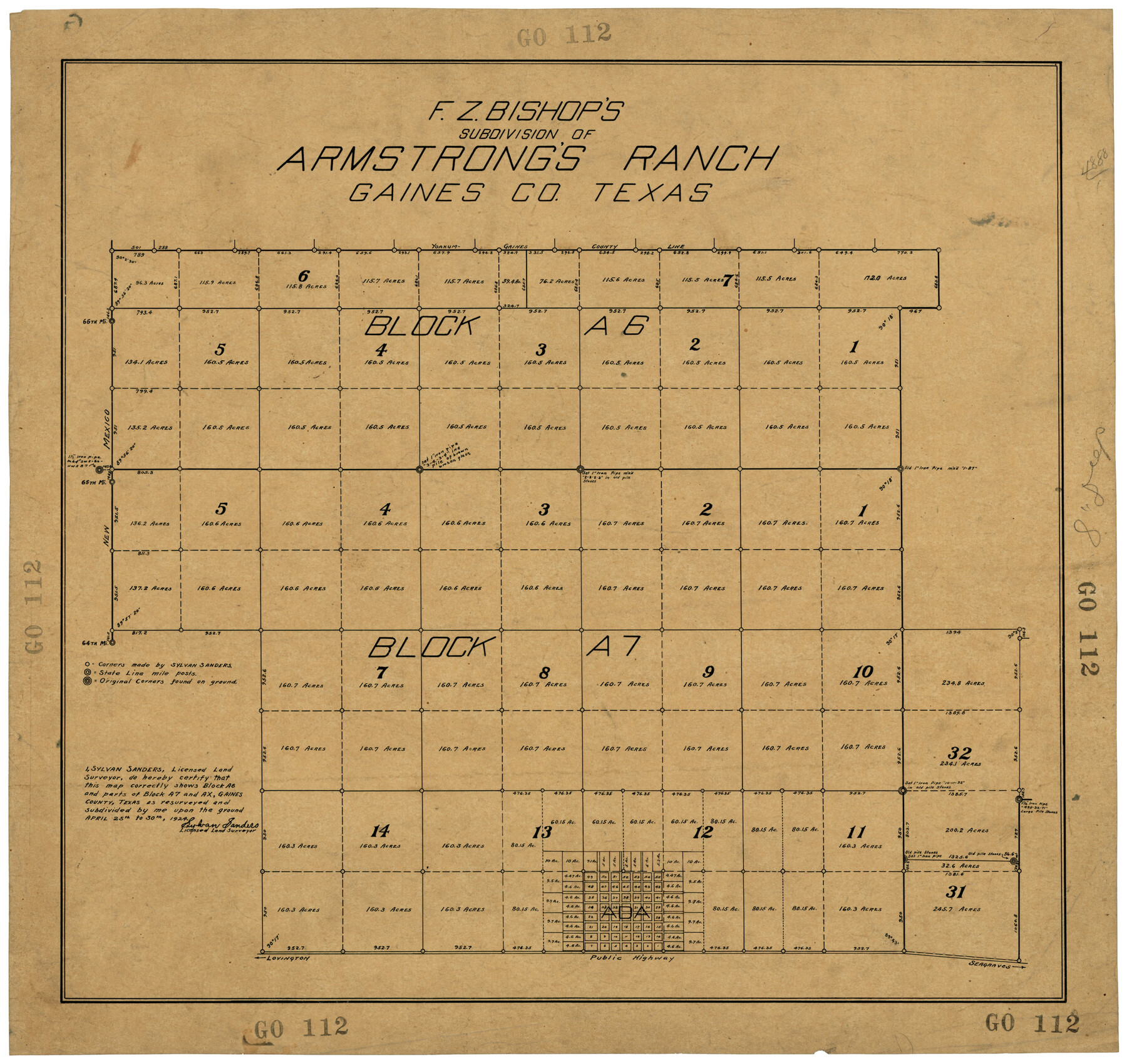
F. Z. Bishop's Subdivision of Armstrong's Ranch, Gaines County, Texas
GO112
-
Map/Doc
92653
-
Collection
Twichell Survey Records
-
Object Dates
4/30/1924 (Creation Date)
-
People and Organizations
Sylvan Sanders (Surveyor/Engineer)
-
Counties
Gaines
-
Height x Width
22.7 x 21.5 inches
57.7 x 54.6 cm
Part of: Twichell Survey Records
Tracing of J. M. Morgan's Map Showing X-LIT Fence Line

Print $20.00
- Digital $50.00
Tracing of J. M. Morgan's Map Showing X-LIT Fence Line
1916
Size 9.5 x 22.7 inches
Map/Doc 91809
[University Lands Blocks 16, 18, 19 and 20]
![91593, [University Lands Blocks 16, 18, 19 and 20], Twichell Survey Records](https://historictexasmaps.com/wmedia_w700/maps/91593-1.tif.jpg)
Print $3.00
- Digital $50.00
[University Lands Blocks 16, 18, 19 and 20]
Size 8.8 x 16.8 inches
Map/Doc 91593
Working Sketch in Randall and Swisher Cos.

Print $20.00
- Digital $50.00
Working Sketch in Randall and Swisher Cos.
1917
Size 14.6 x 36.3 inches
Map/Doc 93048
[B. S. & F. Block 9 and surrounding area]
![93070, [B. S. & F. Block 9 and surrounding area], Twichell Survey Records](https://historictexasmaps.com/wmedia_w700/maps/93070-1.tif.jpg)
Print $20.00
- Digital $50.00
[B. S. & F. Block 9 and surrounding area]
Size 18.3 x 26.1 inches
Map/Doc 93070
Plat Showing Proposed Dam & Reservoir Under Application No. 561 Located at Mouth of Clear Fork of Brazos River

Print $20.00
- Digital $50.00
Plat Showing Proposed Dam & Reservoir Under Application No. 561 Located at Mouth of Clear Fork of Brazos River
1921
Size 24.0 x 16.6 inches
Map/Doc 92094
Working Sketch in Wheeler County [showing East line of County along border with Oklahoma]
![92085, Working Sketch in Wheeler County [showing East line of County along border with Oklahoma], Twichell Survey Records](https://historictexasmaps.com/wmedia_w700/maps/92085-1.tif.jpg)
Print $20.00
- Digital $50.00
Working Sketch in Wheeler County [showing East line of County along border with Oklahoma]
1910
Size 4.8 x 26.1 inches
Map/Doc 92085
[Part of Block D7]
![91944, [Part of Block D7], Twichell Survey Records](https://historictexasmaps.com/wmedia_w700/maps/91944-1.tif.jpg)
Print $20.00
- Digital $50.00
[Part of Block D7]
Size 36.5 x 18.8 inches
Map/Doc 91944
Working Sketch in Eastland County

Print $20.00
- Digital $50.00
Working Sketch in Eastland County
1919
Size 20.1 x 14.6 inches
Map/Doc 90931
[PSL Block B-19]
![89811, [PSL Block B-19], Twichell Survey Records](https://historictexasmaps.com/wmedia_w700/maps/89811-1.tif.jpg)
Print $40.00
- Digital $50.00
[PSL Block B-19]
Size 43.7 x 56.6 inches
Map/Doc 89811
Sketch showing resurvey of Blk 34 Tsp. 4 North

Print $20.00
- Digital $50.00
Sketch showing resurvey of Blk 34 Tsp. 4 North
1917
Size 20.8 x 24.5 inches
Map/Doc 90571
[Map showing Sanborn's Addition and Denver Heights Addition]
![91829, [Map showing Sanborn's Addition and Denver Heights Addition], Twichell Survey Records](https://historictexasmaps.com/wmedia_w700/maps/91829-1.tif.jpg)
Print $20.00
- Digital $50.00
[Map showing Sanborn's Addition and Denver Heights Addition]
Size 22.5 x 38.9 inches
Map/Doc 91829
Stonewall County

Print $20.00
- Digital $50.00
Stonewall County
1889
Size 19.6 x 24.3 inches
Map/Doc 91883
You may also like
Bailey County Sketch File 6

Print $40.00
- Digital $50.00
Bailey County Sketch File 6
Size 26.5 x 31.9 inches
Map/Doc 10884
Edwards County Rolled Sketch JFW

Print $20.00
- Digital $50.00
Edwards County Rolled Sketch JFW
1936
Size 39.5 x 39.4 inches
Map/Doc 8843
Midland County Working Sketch Graphic Index

Print $20.00
- Digital $50.00
Midland County Working Sketch Graphic Index
1930
Size 43.3 x 35.3 inches
Map/Doc 76641
Shaw Farm, State Prison Farm, Bowie County

Print $20.00
- Digital $50.00
Shaw Farm, State Prison Farm, Bowie County
Size 15.7 x 17.2 inches
Map/Doc 82854

Fort Bend County Sketch File 24

Print $20.00
- Digital $50.00
Fort Bend County Sketch File 24
1890
Size 23.5 x 32.4 inches
Map/Doc 11509
Galveston County Working Sketch 4

Print $20.00
- Digital $50.00
Galveston County Working Sketch 4
1930
Size 19.7 x 17.2 inches
Map/Doc 69341
Nueces County Rolled Sketch 40

Print $101.00
- Digital $50.00
Nueces County Rolled Sketch 40
1962
Size 10.3 x 15.3 inches
Map/Doc 47850
Galveston County Sketch File 50

Print $70.00
- Digital $50.00
Galveston County Sketch File 50
Size 14.2 x 8.7 inches
Map/Doc 23481
Blanco County Working Sketch 26

Print $40.00
- Digital $50.00
Blanco County Working Sketch 26
1969
Size 52.7 x 38.7 inches
Map/Doc 67386
Gray County Working Sketch 1

Print $40.00
- Digital $50.00
Gray County Working Sketch 1
Size 121.0 x 38.8 inches
Map/Doc 63232
Flight Mission No. BRA-8M, Frame 133, Jefferson County

Print $20.00
- Digital $50.00
Flight Mission No. BRA-8M, Frame 133, Jefferson County
1953
Size 18.7 x 22.3 inches
Map/Doc 85629