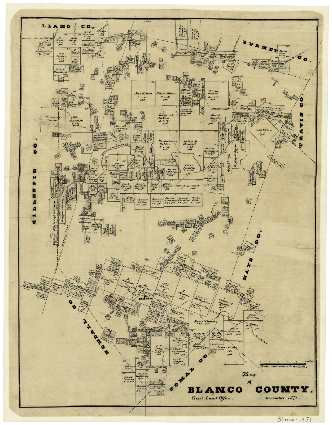
Map of Blanco County
-
Map/Doc
3304
-
Collection
General Map Collection
-
Object Dates
12/1871 (Creation Date)
-
People and Organizations
Texas General Land Office (Publisher)
-
Counties
Blanco
-
Subjects
County
-
Height x Width
22.1 x 17.2 inches
56.1 x 43.7 cm
-
Features
Shovel Mountain
Little Blanco [River]
Rio Blanco
Martin's Fork of Rio Blanco
Blanco
Miller's Creek
William's Creek
Rio Pedernales
Grape Creek
Cypress Creek
King's Creek
Little Cypress Creek
Double Horn Creek
Flat Rock Creek
Slick Rock Creek
Pot Creek
Comanche Creek
Coal Creek
Webb's Creek
Part of: General Map Collection
Andrews County Rolled Sketch 23

Print $40.00
- Digital $50.00
Andrews County Rolled Sketch 23
1946
Size 78.0 x 13.7 inches
Map/Doc 8396
Moore County Working Sketch Graphic Index

Print $20.00
- Digital $50.00
Moore County Working Sketch Graphic Index
1932
Size 41.3 x 39.0 inches
Map/Doc 76648
Reagan County Rolled Sketch 6

Print $20.00
- Digital $50.00
Reagan County Rolled Sketch 6
Size 17.8 x 17.3 inches
Map/Doc 7435
Jackson County Rolled Sketch 3B

Print $20.00
- Digital $50.00
Jackson County Rolled Sketch 3B
1913
Size 23.7 x 21.8 inches
Map/Doc 6338
Liberty County Working Sketch 36

Print $20.00
- Digital $50.00
Liberty County Working Sketch 36
1948
Size 24.3 x 25.0 inches
Map/Doc 70495
Ward County Working Sketch 6

Print $20.00
- Digital $50.00
Ward County Working Sketch 6
1945
Size 23.4 x 24.5 inches
Map/Doc 72312
Rusk County Sketch File 18

Print $4.00
Rusk County Sketch File 18
Size 8.3 x 8.9 inches
Map/Doc 35524
Flight Mission No. DAG-19K, Frame 56, Matagorda County

Print $20.00
- Digital $50.00
Flight Mission No. DAG-19K, Frame 56, Matagorda County
1952
Size 18.5 x 22.3 inches
Map/Doc 86383
Kaufman County Boundary File 6b

Print $6.00
- Digital $50.00
Kaufman County Boundary File 6b
Size 14.2 x 8.5 inches
Map/Doc 55966
King County Rolled Sketch 10

Print $20.00
- Digital $50.00
King County Rolled Sketch 10
Size 38.9 x 33.7 inches
Map/Doc 6532
Crockett County Sketch File 50a

Print $11.00
- Digital $50.00
Crockett County Sketch File 50a
Size 14.0 x 9.3 inches
Map/Doc 19807
Crockett County Sketch File 12

Print $20.00
- Digital $50.00
Crockett County Sketch File 12
Size 26.8 x 18.9 inches
Map/Doc 11216
You may also like
Collingsworth County Working Sketch 2

Print $40.00
- Digital $50.00
Collingsworth County Working Sketch 2
1957
Size 44.2 x 122.7 inches
Map/Doc 68090
Duval County Working Sketch 27

Print $20.00
- Digital $50.00
Duval County Working Sketch 27
1947
Size 20.7 x 16.8 inches
Map/Doc 68751
Jasper County Rolled Sketch 7B

Print $20.00
- Digital $50.00
Jasper County Rolled Sketch 7B
Size 19.7 x 11.6 inches
Map/Doc 6355
Starr County Sketch File 42

Print $20.00
- Digital $50.00
Starr County Sketch File 42
1941
Size 19.0 x 21.6 inches
Map/Doc 12341
Americae Pars Borealis, Florida, Baccalaos, Canada, Corterealis

Print $20.00
- Digital $50.00
Americae Pars Borealis, Florida, Baccalaos, Canada, Corterealis
1593
Size 16.2 x 22.1 inches
Map/Doc 93832
Bexar County Rolled Sketch 4

Print $20.00
- Digital $50.00
Bexar County Rolled Sketch 4
Size 24.3 x 36.8 inches
Map/Doc 5137
Dawson County Sketch File 20

Print $20.00
- Digital $50.00
Dawson County Sketch File 20
1951
Size 13.2 x 21.5 inches
Map/Doc 11296
[Map showing T&P Lands in El Paso County]
![88933, [Map showing T&P Lands in El Paso County], Library of Congress](https://historictexasmaps.com/wmedia_w700/maps/88933.tif.jpg)
Print $20.00
[Map showing T&P Lands in El Paso County]
Size 17.2 x 22.1 inches
Map/Doc 88933
McCulloch County Rolled Sketch 8

Print $40.00
- Digital $50.00
McCulloch County Rolled Sketch 8
1982
Size 51.3 x 31.4 inches
Map/Doc 10292
Henderson County Boundary File 3

Print $32.00
- Digital $50.00
Henderson County Boundary File 3
Size 6.3 x 14.0 inches
Map/Doc 54669
Rio Grande Rectification Project, El Paso and Juarez Valley

Print $20.00
- Digital $50.00
Rio Grande Rectification Project, El Paso and Juarez Valley
1935
Size 10.7 x 29.6 inches
Map/Doc 60859
Lee County Working Sketch 1

Print $20.00
- Digital $50.00
Lee County Working Sketch 1
1940
Size 26.7 x 26.8 inches
Map/Doc 70380