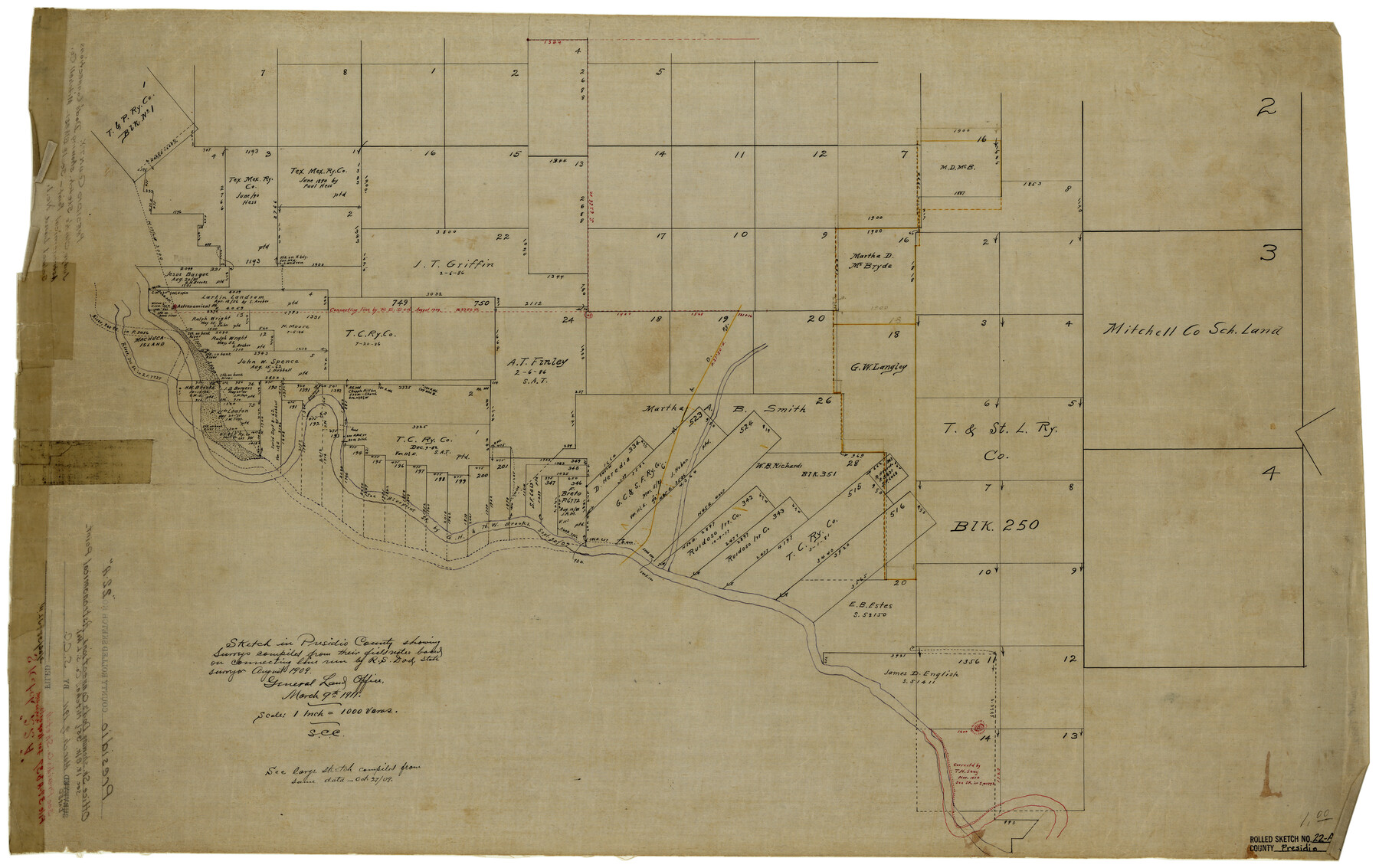
Presidio County Rolled Sketch 22A
Sketch in Presidio County showing surveys compiled from their field notes based on connecting line run by R.S. Dod, State Surveyor
-
Map/Doc
7332
-
Collection
General Map Collection
-
Object Dates
8/1909 (Creation Date)
3/9/1911 (Creation Date)
-
Counties
Presidio
-
Subjects
Surveying Rolled Sketch
-
Height x Width
20.6 x 31.9 inches
52.3 x 81.0 cm
-
Medium
linen, manuscript
-
Scale
1" = 1000 varas
Part of: General Map Collection
Uvalde County Working Sketch 19

Print $20.00
- Digital $50.00
Uvalde County Working Sketch 19
1948
Size 25.8 x 39.8 inches
Map/Doc 72089
Young County Rolled Sketch 19

Print $20.00
- Digital $50.00
Young County Rolled Sketch 19
2021
Size 24.3 x 30.4 inches
Map/Doc 97023
Presidio County Rolled Sketch T-3

Print $20.00
- Digital $50.00
Presidio County Rolled Sketch T-3
Size 36.6 x 28.9 inches
Map/Doc 7417
Mason County Boundary File 3

Print $52.00
- Digital $50.00
Mason County Boundary File 3
Size 13.7 x 8.7 inches
Map/Doc 56838
Galveston County Rolled Sketch JR

Print $20.00
- Digital $50.00
Galveston County Rolled Sketch JR
1938
Size 37.5 x 36.7 inches
Map/Doc 9086
Duval County Sketch File 37

Print $8.00
- Digital $50.00
Duval County Sketch File 37
Size 13.7 x 9.0 inches
Map/Doc 21385
Willacy County Aerial Photograph Index Sheet 1

Print $20.00
- Digital $50.00
Willacy County Aerial Photograph Index Sheet 1
1940
Size 24.0 x 19.7 inches
Map/Doc 83755
Grimes County Working Sketch 16

Print $20.00
- Digital $50.00
Grimes County Working Sketch 16
1995
Size 41.6 x 33.1 inches
Map/Doc 63307
Map of Runnels County

Print $20.00
- Digital $50.00
Map of Runnels County
1898
Size 44.7 x 39.5 inches
Map/Doc 63008
Wise County Working Sketch 7

Print $20.00
- Digital $50.00
Wise County Working Sketch 7
1950
Size 26.2 x 24.8 inches
Map/Doc 72621
Flight Mission No. DQN-2K, Frame 34, Calhoun County

Print $20.00
- Digital $50.00
Flight Mission No. DQN-2K, Frame 34, Calhoun County
1953
Size 18.5 x 22.2 inches
Map/Doc 84241
Dimmit County Working Sketch 39

Print $20.00
- Digital $50.00
Dimmit County Working Sketch 39
1967
Size 25.5 x 30.0 inches
Map/Doc 68700
You may also like
Stephens County Sketch File 9

Print $42.00
- Digital $50.00
Stephens County Sketch File 9
Size 8.2 x 5.5 inches
Map/Doc 37029
Tom Green County Sketch File 63A

Print $20.00
- Digital $50.00
Tom Green County Sketch File 63A
1891
Size 24.9 x 34.5 inches
Map/Doc 12446
Brewster County Rolled Sketch 156

Print $156.00
- Digital $50.00
Brewster County Rolled Sketch 156
2005
Map/Doc 85390
The North Part of America

Print $20.00
- Digital $50.00
The North Part of America
1625
Size 13.1 x 14.8 inches
Map/Doc 93815
Collingsworth County Working Sketch 4
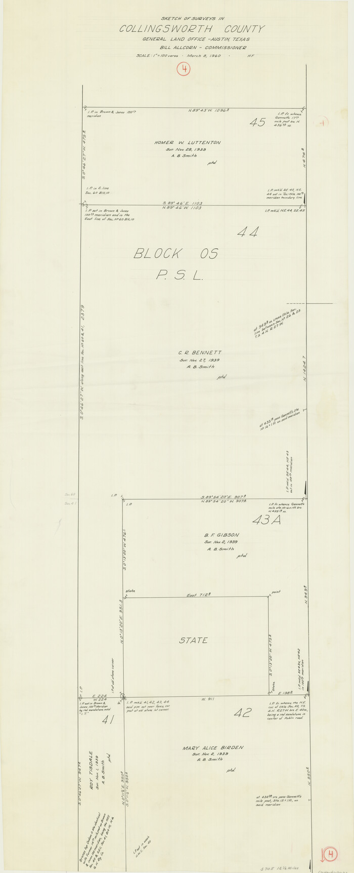
Print $20.00
- Digital $50.00
Collingsworth County Working Sketch 4
1960
Size 42.6 x 17.3 inches
Map/Doc 68092
Interior de Mexico

Print $20.00
- Digital $50.00
Interior de Mexico
1836
Size 13.5 x 18.0 inches
Map/Doc 97350
Flight Mission No. CRE-2R, Frame 80, Jackson County

Print $20.00
- Digital $50.00
Flight Mission No. CRE-2R, Frame 80, Jackson County
1956
Size 18.7 x 22.3 inches
Map/Doc 85352
Nueces County Rolled Sketch 27

Print $40.00
- Digital $50.00
Nueces County Rolled Sketch 27
1946
Size 180.8 x 12.6 inches
Map/Doc 9596
Red River County

Print $20.00
- Digital $50.00
Red River County
1860
Size 23.0 x 20.8 inches
Map/Doc 3980
Map of Atascosa County, Texas

Print $20.00
- Digital $50.00
Map of Atascosa County, Texas
1879
Size 23.7 x 29.0 inches
Map/Doc 688
State Map of Kansas Showing Productive Geological Formation of Each Oil Field

Print $20.00
- Digital $50.00
State Map of Kansas Showing Productive Geological Formation of Each Oil Field
1937
Size 45.5 x 29.8 inches
Map/Doc 92043
No. 2 Chart of Corpus Christi Pass, Texas

Print $20.00
- Digital $50.00
No. 2 Chart of Corpus Christi Pass, Texas
1878
Size 18.3 x 27.3 inches
Map/Doc 73021