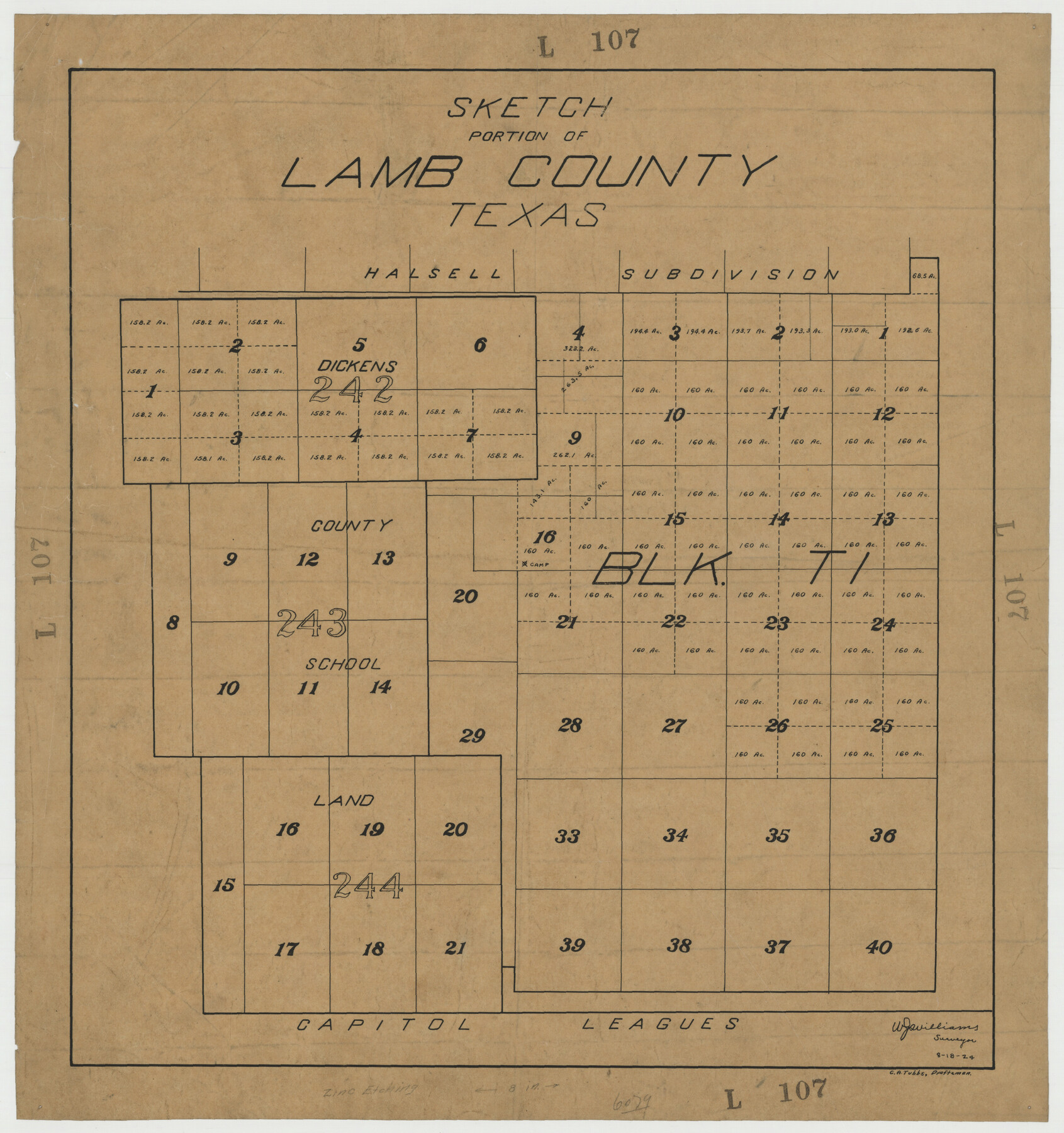
Sketch Portion of Lamb County, Texas
L107
-
Map/Doc
92176
-
Collection
Twichell Survey Records
-
Object Dates
8/18/1924 (Creation Date)
-
People and Organizations
C.A. Tubbs (Draftsman)
W.J. Williams (Surveyor/Engineer)
-
Counties
Lamb
-
Height x Width
19.9 x 21.4 inches
50.6 x 54.4 cm
Part of: Twichell Survey Records
[T. & P. Block 44, Township 1S]
![90926, [T. & P. Block 44, Township 1S], Twichell Survey Records](https://historictexasmaps.com/wmedia_w700/maps/90926-1.tif.jpg)
Print $20.00
- Digital $50.00
[T. & P. Block 44, Township 1S]
Size 17.6 x 22.6 inches
Map/Doc 90926
[Part of H. & G. N. Blocks 2 and D-13]
![90490, [Part of H. & G. N. Blocks 2 and D-13], Twichell Survey Records](https://historictexasmaps.com/wmedia_w700/maps/90490-1.tif.jpg)
Print $20.00
- Digital $50.00
[Part of H. & G. N. Blocks 2 and D-13]
1907
Size 14.1 x 17.7 inches
Map/Doc 90490
[Skletch filed with corrected field notes of Surveys 27, 28, 29 and 30, Block B-19 Public School Lands]
![93056, [Skletch filed with corrected field notes of Surveys 27, 28, 29 and 30, Block B-19 Public School Lands], Twichell Survey Records](https://historictexasmaps.com/wmedia_w700/maps/93056-1.tif.jpg)
Print $20.00
- Digital $50.00
[Skletch filed with corrected field notes of Surveys 27, 28, 29 and 30, Block B-19 Public School Lands]
1943
Size 19.3 x 15.4 inches
Map/Doc 93056
Topographic Map, Low Rent Housing Project Texas 18-1, Housing Authority of the City of Lubbock (Plan No. 2)

Print $20.00
- Digital $50.00
Topographic Map, Low Rent Housing Project Texas 18-1, Housing Authority of the City of Lubbock (Plan No. 2)
1941
Size 42.4 x 27.2 inches
Map/Doc 92757
[Parts of Public School Land Blocks 39, 31, C-40, C-42, E. L. & R. R. Blocks H, I]
![91271, [Parts of Public School Land Blocks 39, 31, C-40, C-42, E. L. & R. R. Blocks H, I], Twichell Survey Records](https://historictexasmaps.com/wmedia_w700/maps/91271-1.tif.jpg)
Print $20.00
- Digital $50.00
[Parts of Public School Land Blocks 39, 31, C-40, C-42, E. L. & R. R. Blocks H, I]
Size 14.2 x 19.5 inches
Map/Doc 91271
[Part of Map Showing Terry & Lynn County Line Highlighting Parts of Blocks D8, E, 9]
![92264, [Part of Map Showing Terry & Lynn County Line Highlighting Parts of Blocks D8, E, 9], Twichell Survey Records](https://historictexasmaps.com/wmedia_w700/maps/92264-1.tif.jpg)
Print $20.00
- Digital $50.00
[Part of Map Showing Terry & Lynn County Line Highlighting Parts of Blocks D8, E, 9]
Size 18.2 x 10.9 inches
Map/Doc 92264
Leveland and Adjacent Subdivisions of League 28, Hood County School Land Hockley County, Texas

Print $40.00
- Digital $50.00
Leveland and Adjacent Subdivisions of League 28, Hood County School Land Hockley County, Texas
Size 42.4 x 50.4 inches
Map/Doc 89848
![90573, [Block 3], Twichell Survey Records](https://historictexasmaps.com/wmedia_w700/maps/90573-1.tif.jpg)
Sketch of Part of Moore County

Print $20.00
- Digital $50.00
Sketch of Part of Moore County
1912
Size 30.1 x 33.6 inches
Map/Doc 92293
Map of Dalhart

Print $20.00
- Digital $50.00
Map of Dalhart
1905
Size 23.5 x 32.0 inches
Map/Doc 92146

Sketch in Cochran County, Texas

Print $20.00
- Digital $50.00
Sketch in Cochran County, Texas
1940
Size 33.1 x 26.5 inches
Map/Doc 92489
You may also like
Hopkins County Sketch File 21

Print $24.00
- Digital $50.00
Hopkins County Sketch File 21
1871
Size 8.1 x 12.5 inches
Map/Doc 26727
McCulloch County

Print $20.00
- Digital $50.00
McCulloch County
1949
Size 47.0 x 35.8 inches
Map/Doc 73234
Flight Mission No. BRE-3P, Frame 38, Nueces County

Print $20.00
- Digital $50.00
Flight Mission No. BRE-3P, Frame 38, Nueces County
1956
Size 18.5 x 22.4 inches
Map/Doc 86816
Working Sketch Crockett County

Print $20.00
- Digital $50.00
Working Sketch Crockett County
1924
Size 33.3 x 37.6 inches
Map/Doc 90318
[Map of Coahuila and Nuevo Leon]
![97128, [Map of Coahuila and Nuevo Leon], General Map Collection](https://historictexasmaps.com/wmedia_w700/maps/97128.tif.jpg)
Print $20.00
- Digital $50.00
[Map of Coahuila and Nuevo Leon]
1873
Size 16.8 x 11.6 inches
Map/Doc 97128
Ward County Working Sketch 8

Print $20.00
- Digital $50.00
Ward County Working Sketch 8
1946
Size 22.7 x 33.7 inches
Map/Doc 72314
Williamson County Sketch File 9

Print $20.00
- Digital $50.00
Williamson County Sketch File 9
1850
Size 17.4 x 21.6 inches
Map/Doc 12692
Kerr County Working Sketch 14

Print $20.00
- Digital $50.00
Kerr County Working Sketch 14
1952
Size 26.5 x 24.5 inches
Map/Doc 70045
Gray County Boundary File 3a

Print $4.00
- Digital $50.00
Gray County Boundary File 3a
Size 14.2 x 8.8 inches
Map/Doc 53874
Fractional Township No. 7 South Range No. 7 West of the Indian Meridian, Indian Territory

Print $20.00
- Digital $50.00
Fractional Township No. 7 South Range No. 7 West of the Indian Meridian, Indian Territory
1898
Size 19.2 x 24.4 inches
Map/Doc 75168
General Highway Map, Galveston County, Texas

Print $20.00
General Highway Map, Galveston County, Texas
1939
Size 18.5 x 25.0 inches
Map/Doc 79096
P.J. Lawless Addition of Part of Outlots 29 and 30, Division D, Austin, Texas.

Print $20.00
- Digital $50.00
P.J. Lawless Addition of Part of Outlots 29 and 30, Division D, Austin, Texas.
1916
Size 13.6 x 16.6 inches
Map/Doc 502