Brewster County Sketch File N-8
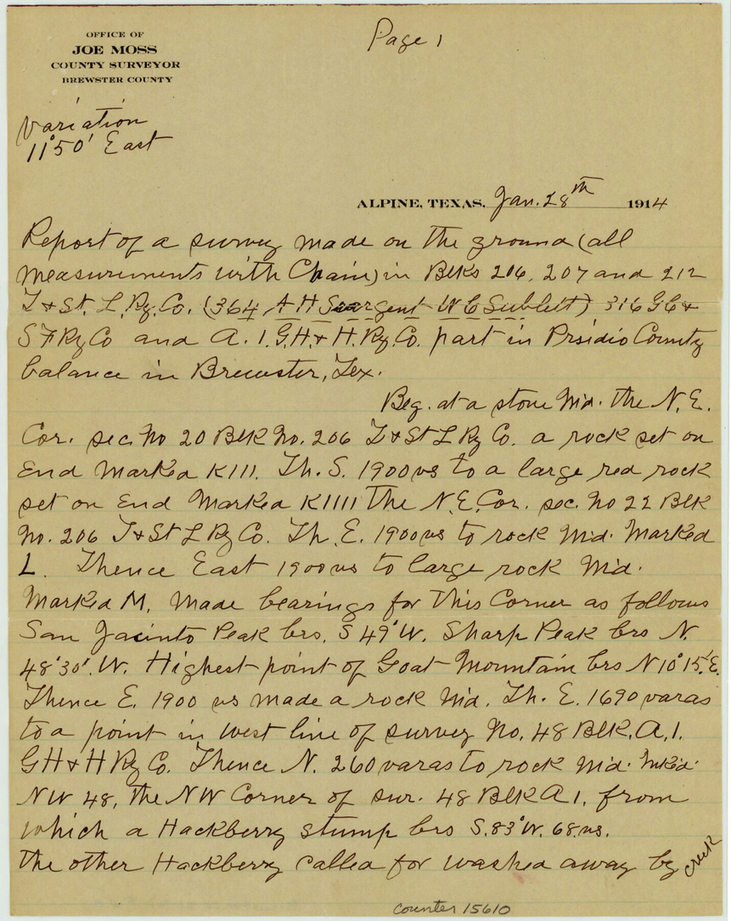
[Connections between T. & St. L. Ry. Co. Block 206 and G. H. & S. A. R.R. Co. Block A1]
-
Map/Doc
15610
-
Collection
General Map Collection
-
Object Dates
1914/1/28 (Creation Date)
1914/2/3 (Correspondence Date)
1914/2/5 (File Date)
-
People and Organizations
Joe Moss (Surveyor/Engineer)
-
Counties
Brewster Presidio
-
Subjects
Surveying Sketch File
-
Height x Width
10.8 x 8.6 inches
27.4 x 21.8 cm
-
Medium
paper, manuscript
-
Comments
See Brewster County Sketch File N-9 (10964) for sketch.
-
Features
San Jacinto Peak
McKinney Mountain
Little McKinney Mountain
Related maps
Brewster County Sketch File N-9

Print $40.00
- Digital $50.00
Brewster County Sketch File N-9
Size 17.4 x 15.7 inches
Map/Doc 10964
Part of: General Map Collection
Matagorda County NRC Article 33.136 Sketch 24

Print $78.00
Matagorda County NRC Article 33.136 Sketch 24
2025
Map/Doc 97509
Harrison County Sketch File 21

Print $20.00
- Digital $50.00
Harrison County Sketch File 21
1892
Size 20.2 x 25.7 inches
Map/Doc 11694
Wheeler County Working Sketch 4

Print $40.00
- Digital $50.00
Wheeler County Working Sketch 4
1972
Size 58.9 x 47.1 inches
Map/Doc 72493
Current Miscellaneous File 70

Print $10.00
- Digital $50.00
Current Miscellaneous File 70
Size 14.2 x 8.9 inches
Map/Doc 74150
Flight Mission No. BRA-7M, Frame 190, Jefferson County

Print $20.00
- Digital $50.00
Flight Mission No. BRA-7M, Frame 190, Jefferson County
1953
Size 18.7 x 22.3 inches
Map/Doc 85558
Bowie County Sketch File 10

Print $8.00
- Digital $50.00
Bowie County Sketch File 10
1992
Size 11.1 x 8.8 inches
Map/Doc 14912
Palo Pinto County Sketch File 20

Print $6.00
- Digital $50.00
Palo Pinto County Sketch File 20
1891
Size 12.5 x 10.9 inches
Map/Doc 33402
Roberts County

Print $20.00
- Digital $50.00
Roberts County
1878
Size 20.1 x 18.0 inches
Map/Doc 3991
Young County Sketch File 5

Print $40.00
- Digital $50.00
Young County Sketch File 5
1855
Size 12.8 x 15.6 inches
Map/Doc 49662
Stonewall County Sketch File 14

Print $20.00
- Digital $50.00
Stonewall County Sketch File 14
1901
Size 21.5 x 18.3 inches
Map/Doc 12366
Nueces County Rolled Sketch 116

Print $40.00
- Digital $50.00
Nueces County Rolled Sketch 116
Size 29.6 x 58.3 inches
Map/Doc 7141
Lamb County Sketch File 14

Print $6.00
- Digital $50.00
Lamb County Sketch File 14
1914
Size 7.3 x 8.7 inches
Map/Doc 29374
You may also like
Brazos River, Brazos River Sheet 1

Print $20.00
- Digital $50.00
Brazos River, Brazos River Sheet 1
1926
Size 20.6 x 24.6 inches
Map/Doc 78264
Outer Continental Shelf Leasing Maps (Louisiana Offshore Operations)

Print $20.00
- Digital $50.00
Outer Continental Shelf Leasing Maps (Louisiana Offshore Operations)
1955
Size 11.1 x 13.3 inches
Map/Doc 76090

Rio Grande, Madero Sheet

Print $20.00
- Digital $50.00
Rio Grande, Madero Sheet
1931
Size 33.0 x 38.5 inches
Map/Doc 65124
Irion County Rolled Sketch 24

Print $40.00
- Digital $50.00
Irion County Rolled Sketch 24
Size 49.4 x 37.4 inches
Map/Doc 9257
Ochiltree County Sketch File 2

Print $38.00
- Digital $50.00
Ochiltree County Sketch File 2
1903
Size 11.3 x 8.6 inches
Map/Doc 33168
Hutchinson County Rolled Sketch 44-6

Print $20.00
- Digital $50.00
Hutchinson County Rolled Sketch 44-6
2002
Size 24.0 x 36.0 inches
Map/Doc 77542

Stephens County Sketch File 3

Print $4.00
- Digital $50.00
Stephens County Sketch File 3
Size 8.6 x 10.6 inches
Map/Doc 37015
[D. & S. E. Surs., G. C. & S. F. Blk. 9 west of University Land Blks. 49 and 50]
![90308, [D. & S. E. Surs., G. C. & S. F. Blk. 9 west of University Land Blks. 49 and 50], Twichell Survey Records](https://historictexasmaps.com/wmedia_w700/maps/90308-1.tif.jpg)
Print $3.00
- Digital $50.00
[D. & S. E. Surs., G. C. & S. F. Blk. 9 west of University Land Blks. 49 and 50]
Size 11.3 x 15.4 inches
Map/Doc 90308
Upton County Boundary File 2a

Print $30.00
- Digital $50.00
Upton County Boundary File 2a
Size 14.4 x 9.0 inches
Map/Doc 59520
Intracoastal Waterway in Texas - Corpus Christi to Point Isabel including Arroyo Colorado to Mo. Pac. R.R. Bridge Near Harlingen

Print $20.00
- Digital $50.00
Intracoastal Waterway in Texas - Corpus Christi to Point Isabel including Arroyo Colorado to Mo. Pac. R.R. Bridge Near Harlingen
1933
Size 28.1 x 40.9 inches
Map/Doc 61851