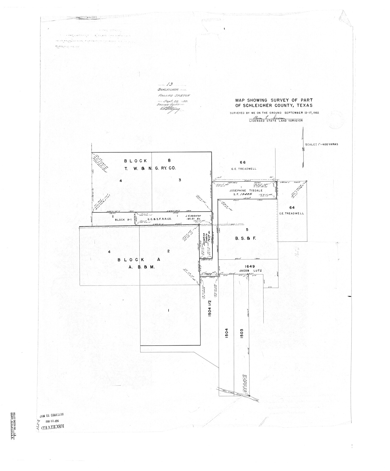
Schleicher County Rolled Sketch 13
Map showing survey of part of Schleicher County, Texas
-
Map/Doc
7756
-
Collection
General Map Collection
-
Object Dates
1952/9/22 (File Date)
1952/9/17 (Survey Date)
-
People and Organizations
Byron L. Simpson (Surveyor/Engineer)
-
Counties
Schleicher
-
Subjects
Surveying Rolled Sketch
-
Height x Width
37.2 x 30.8 inches
94.5 x 78.2 cm
-
Scale
1" = 400 varas
Part of: General Map Collection
Hays County Sketch File 34

Print $15.00
- Digital $50.00
Hays County Sketch File 34
1954
Size 14.3 x 8.9 inches
Map/Doc 26270

Terrell County Working Sketch 74

Print $20.00
- Digital $50.00
Terrell County Working Sketch 74
1981
Size 37.5 x 24.6 inches
Map/Doc 69595
Panola County Sketch File 17

Print $20.00
- Digital $50.00
Panola County Sketch File 17
Size 15.2 x 17.7 inches
Map/Doc 12137
[Three Mile Line and Three League Line]
![76120, [Three Mile Line and Three League Line], General Map Collection](https://historictexasmaps.com/wmedia_w700/maps/76120.tif.jpg)
Print $20.00
- Digital $50.00
[Three Mile Line and Three League Line]
1973
Size 43.2 x 33.3 inches
Map/Doc 76120
[Letter regarding surveys in Coryell County]
![69754, [Letter regarding surveys in Coryell County], General Map Collection](https://historictexasmaps.com/wmedia_w700/maps/69754.tif.jpg)
Print $2.00
- Digital $50.00
[Letter regarding surveys in Coryell County]
1846
Size 7.7 x 6.4 inches
Map/Doc 69754
Midland County Working Sketch 7

Print $20.00
- Digital $50.00
Midland County Working Sketch 7
1950
Size 34.6 x 28.3 inches
Map/Doc 70987
Runnels County

Print $20.00
- Digital $50.00
Runnels County
1948
Size 46.5 x 36.4 inches
Map/Doc 77411

Milam County Sketch File 2

Print $4.00
- Digital $50.00
Milam County Sketch File 2
1849
Size 8.0 x 12.4 inches
Map/Doc 31627
Sutton County Sketch File 56

Print $8.00
Sutton County Sketch File 56
1953
Size 11.2 x 9.0 inches
Map/Doc 37538
Ochiltree County

Print $20.00
- Digital $50.00
Ochiltree County
1889
Size 23.1 x 19.5 inches
Map/Doc 3923
You may also like
Map of the Town of Giddings

Print $20.00
- Digital $50.00
Map of the Town of Giddings
1871
Size 23.9 x 29.8 inches
Map/Doc 89270
Stephens County Texas

Print $20.00
- Digital $50.00
Stephens County Texas
Size 20.8 x 18.6 inches
Map/Doc 4627
[Sketch of a portion of a Bastrop District GLO map]
![90240, [Sketch of a portion of a Bastrop District GLO map], Twichell Survey Records](https://historictexasmaps.com/wmedia_w700/maps/90240-1.tif.jpg)
Print $3.00
- Digital $50.00
[Sketch of a portion of a Bastrop District GLO map]
1923
Size 11.4 x 15.1 inches
Map/Doc 90240
Dickens County Sketch File E

Print $8.00
- Digital $50.00
Dickens County Sketch File E
Size 11.3 x 8.7 inches
Map/Doc 20843
Comanche County Sketch File 22a

Print $2.00
- Digital $50.00
Comanche County Sketch File 22a
Size 8.2 x 7.6 inches
Map/Doc 19108
General Highway Map. Detail of Cities and Towns in Jefferson County, Texas. City Map of Port Arthur and vicinity, Jefferson County, Texas

Print $20.00
General Highway Map. Detail of Cities and Towns in Jefferson County, Texas. City Map of Port Arthur and vicinity, Jefferson County, Texas
1961
Size 18.0 x 24.7 inches
Map/Doc 79540
Map of Part of Texas Prison System, Blue Ridge State Farm near Camp No. 1 Showing Buildings and Property Lines

Print $20.00
- Digital $50.00
Map of Part of Texas Prison System, Blue Ridge State Farm near Camp No. 1 Showing Buildings and Property Lines
Size 20.3 x 25.4 inches
Map/Doc 62980
Roberts County Working Sketch 41

Print $20.00
- Digital $50.00
Roberts County Working Sketch 41
1978
Size 26.6 x 22.6 inches
Map/Doc 63567
Colorado County Rolled Sketch 4

Print $20.00
- Digital $50.00
Colorado County Rolled Sketch 4
1944
Size 31.9 x 21.9 inches
Map/Doc 8643
Upton County Rolled Sketch 12

Print $20.00
- Digital $50.00
Upton County Rolled Sketch 12
Size 30.3 x 38.3 inches
Map/Doc 10036
Flight Mission No. DAG-21K, Frame 33, Matagorda County

Print $20.00
- Digital $50.00
Flight Mission No. DAG-21K, Frame 33, Matagorda County
1952
Size 18.5 x 22.3 inches
Map/Doc 86400
[Sketch showing Blocks M19, 20F, JAD, Z6, 2, 9 and 11]
![89787, [Sketch showing Blocks M19, 20F, JAD, Z6, 2, 9 and 11], Twichell Survey Records](https://historictexasmaps.com/wmedia_w700/maps/89787-1.tif.jpg)
Print $40.00
- Digital $50.00
[Sketch showing Blocks M19, 20F, JAD, Z6, 2, 9 and 11]
Size 42.2 x 54.7 inches
Map/Doc 89787