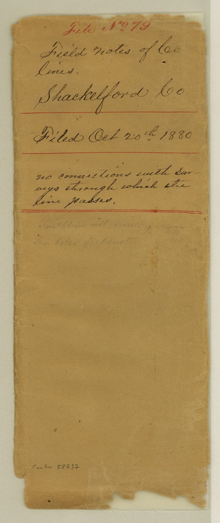
Shackelford County Boundary File 79
Fieldnotes of County Lines
-
Map/Doc
58737
-
Collection
General Map Collection
-
Counties
Shackelford
-
Subjects
County Boundaries
-
Height x Width
9.5 x 4.0 inches
24.1 x 10.2 cm
Part of: General Map Collection
Concho County Working Sketch 19

Print $20.00
- Digital $50.00
Concho County Working Sketch 19
1957
Size 27.3 x 24.9 inches
Map/Doc 68201
Runnels County Working Sketch 21

Print $20.00
- Digital $50.00
Runnels County Working Sketch 21
1951
Size 43.6 x 37.0 inches
Map/Doc 63617
Navigation Maps of Gulf Intracoastal Waterway, Port Arthur to Brownsville, Texas

Print $4.00
- Digital $50.00
Navigation Maps of Gulf Intracoastal Waterway, Port Arthur to Brownsville, Texas
1951
Size 16.7 x 21.5 inches
Map/Doc 65424
Nueces County Sketch File 7

Print $7.00
- Digital $50.00
Nueces County Sketch File 7
1849
Size 11.3 x 9.3 inches
Map/Doc 32509
Freestone County Sketch File 23

Print $6.00
- Digital $50.00
Freestone County Sketch File 23
1918
Size 11.4 x 8.9 inches
Map/Doc 23084
Chambers County Sketch File 50

Print $49.00
- Digital $50.00
Chambers County Sketch File 50
1917
Size 14.4 x 8.8 inches
Map/Doc 18048
Reeves County Rolled Sketch 20

Print $20.00
- Digital $50.00
Reeves County Rolled Sketch 20
Size 32.1 x 38.4 inches
Map/Doc 9852
Ward County Sketch File 8

Print $20.00
- Digital $50.00
Ward County Sketch File 8
Size 13.3 x 22.8 inches
Map/Doc 12599

Gonzales County Working Sketch 15

Print $20.00
- Digital $50.00
Gonzales County Working Sketch 15
1981
Size 31.1 x 22.4 inches
Map/Doc 63231
![94197, New Mexico [Verso], General Map Collection](https://historictexasmaps.com/wmedia_w700/maps/94197.tif.jpg)
Upton County Rolled Sketch 19

Print $40.00
- Digital $50.00
Upton County Rolled Sketch 19
1933
Size 55.2 x 40.0 inches
Map/Doc 10040
You may also like
Flight Mission No. BQY-4M, Frame 42, Harris County

Print $20.00
- Digital $50.00
Flight Mission No. BQY-4M, Frame 42, Harris County
1953
Size 18.7 x 22.4 inches
Map/Doc 85257
Terrell County Rolled Sketch 37

Print $20.00
- Digital $50.00
Terrell County Rolled Sketch 37
1940
Size 23.8 x 33.3 inches
Map/Doc 7941
Matagorda Bay and Approaches

Print $20.00
- Digital $50.00
Matagorda Bay and Approaches
1961
Size 35.0 x 45.0 inches
Map/Doc 73382
Travis County Appraisal District Plat Map 2_2313

Print $20.00
- Digital $50.00
Travis County Appraisal District Plat Map 2_2313
Size 21.4 x 26.3 inches
Map/Doc 94215
Rains County Working Sketch 1

Print $20.00
- Digital $50.00
Rains County Working Sketch 1
Size 12.3 x 17.3 inches
Map/Doc 71827
Flight Mission No. BRE-1P, Frame 96, Nueces County

Print $20.00
- Digital $50.00
Flight Mission No. BRE-1P, Frame 96, Nueces County
1956
Size 18.5 x 22.2 inches
Map/Doc 86667
Flight Mission No. DAG-18K, Frame 189, Matagorda County

Print $20.00
- Digital $50.00
Flight Mission No. DAG-18K, Frame 189, Matagorda County
1952
Size 18.5 x 22.3 inches
Map/Doc 86381
Flight Mission No. DQN-5K, Frame 59, Calhoun County

Print $20.00
- Digital $50.00
Flight Mission No. DQN-5K, Frame 59, Calhoun County
1953
Size 18.7 x 22.3 inches
Map/Doc 84402
Bell County Boundary File 3a

Print $82.00
- Digital $50.00
Bell County Boundary File 3a
Size 11.2 x 8.5 inches
Map/Doc 50502
Section P Tech Memorial Park, Inc.

Print $20.00
- Digital $50.00
Section P Tech Memorial Park, Inc.
1953
Size 21.1 x 32.3 inches
Map/Doc 92353
Sutton County Working Sketch 30

Print $20.00
- Digital $50.00
Sutton County Working Sketch 30
1919
Size 42.6 x 16.9 inches
Map/Doc 62373
Panola County Sketch File 29

Print $7.00
- Digital $50.00
Panola County Sketch File 29
1842
Size 10.0 x 8.1 inches
Map/Doc 33502