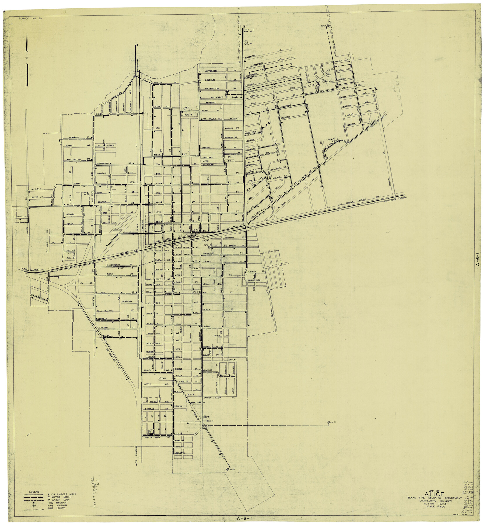
Map of Alice
A-6-1
-
Map/Doc
2212
-
Collection
General Map Collection
-
Object Dates
11/1952 (Creation Date)
-
People and Organizations
Texas Fire Insurance Department (Publisher)
-
Counties
Jim Wells
-
Subjects
City
-
Height x Width
35.5 x 32.8 inches
90.2 x 83.3 cm
-
Medium
blueprint/diazo
-
Scale
1" = 600 ft.
-
Comments
Texas Fire Insurance Department, Engineering Division.
Street map showing locations of water mains, fire hydrants and fire station. -
Features
[Road] to Skidmore
[Road] to Robstown
State Highway No. 44
Old Corpus Christi Highway
[Road] to Corpus Christi
TMRR
Southern Pacific Railroad Company
[Road] to Laredo
U.S. Highway No. 281
[Road] to Edinburg
Part of: General Map Collection
Fayette County Rolled Sketch 1

Print $20.00
- Digital $50.00
Fayette County Rolled Sketch 1
1981
Size 20.9 x 25.8 inches
Map/Doc 5876
Panola County Working Sketch 4

Print $20.00
- Digital $50.00
Panola County Working Sketch 4
1938
Map/Doc 71413
Hutchinson County Rolled Sketch 44-2

Print $20.00
- Digital $50.00
Hutchinson County Rolled Sketch 44-2
2002
Size 24.0 x 36.0 inches
Map/Doc 77538
Matagorda County Aerial Photograph Index Sheet 4

Print $20.00
- Digital $50.00
Matagorda County Aerial Photograph Index Sheet 4
1953
Size 23.6 x 19.5 inches
Map/Doc 83725
Brazoria County Sketch File 21

Print $4.00
- Digital $50.00
Brazoria County Sketch File 21
Size 8.3 x 7.5 inches
Map/Doc 15016
[Surveys along the Red River]
![5, [Surveys along the Red River], General Map Collection](https://historictexasmaps.com/wmedia_w700/maps/5.tif.jpg)
Print $2.00
- Digital $50.00
[Surveys along the Red River]
Size 14.1 x 5.6 inches
Map/Doc 5
San Jacinto River, Water Sheds of the San Jacinto River and Buffalo Bayou

Print $4.00
- Digital $50.00
San Jacinto River, Water Sheds of the San Jacinto River and Buffalo Bayou
Size 28.8 x 20.0 inches
Map/Doc 65149
Coast Chart No. 212 - From Latitude 26° 33' to the Rio Grande Texas

Print $20.00
- Digital $50.00
Coast Chart No. 212 - From Latitude 26° 33' to the Rio Grande Texas
1886
Size 27.2 x 18.2 inches
Map/Doc 72830
Webb County Working Sketch 37

Print $20.00
- Digital $50.00
Webb County Working Sketch 37
1940
Size 25.0 x 20.4 inches
Map/Doc 72402
Bandera County Working Sketch 45

Print $20.00
- Digital $50.00
Bandera County Working Sketch 45
1981
Size 42.4 x 35.5 inches
Map/Doc 67641
North Sulphur River, Bartley Gin Sheet

Print $20.00
- Digital $50.00
North Sulphur River, Bartley Gin Sheet
1928
Size 13.3 x 22.0 inches
Map/Doc 78323
Hunt County Rolled Sketch 5

Print $20.00
- Digital $50.00
Hunt County Rolled Sketch 5
1966
Size 24.7 x 24.5 inches
Map/Doc 6275
You may also like
Map showing those portions of Texas traversed by the Rock Island System and connecting lines

Print $20.00
- Digital $50.00
Map showing those portions of Texas traversed by the Rock Island System and connecting lines
1903
Size 16.4 x 24.0 inches
Map/Doc 96587
Terrell County Sketch File 25A

Print $20.00
- Digital $50.00
Terrell County Sketch File 25A
1890
Size 16.9 x 21.5 inches
Map/Doc 12424
Palo Pinto County Boundary File 4a

Print $34.00
- Digital $50.00
Palo Pinto County Boundary File 4a
Size 13.3 x 8.9 inches
Map/Doc 57817
Rio Grande, Madero Sheet

Print $20.00
- Digital $50.00
Rio Grande, Madero Sheet
1931
Size 33.0 x 38.5 inches
Map/Doc 65124
Hamilton County Working Sketch 27

Print $20.00
- Digital $50.00
Hamilton County Working Sketch 27
1975
Size 43.4 x 34.3 inches
Map/Doc 63365
Limestone County Rolled Sketch 3

Print $20.00
- Digital $50.00
Limestone County Rolled Sketch 3
Size 24.3 x 23.6 inches
Map/Doc 6627
Hays County Sketch File 28

Print $20.00
- Digital $50.00
Hays County Sketch File 28
1912
Size 26.0 x 20.0 inches
Map/Doc 11750
Chambers County Rolled Sketch 23A

Print $40.00
- Digital $50.00
Chambers County Rolled Sketch 23A
1940
Size 77.1 x 36.0 inches
Map/Doc 8592
Irion County Boundary File 3a

Print $2.00
- Digital $50.00
Irion County Boundary File 3a
Size 12.9 x 8.3 inches
Map/Doc 55349
Terrell County Working Sketch 28

Print $20.00
- Digital $50.00
Terrell County Working Sketch 28
1944
Size 42.0 x 41.9 inches
Map/Doc 62178
Val Verde County Sketch File Z6

Print $20.00
- Digital $50.00
Val Verde County Sketch File Z6
Size 29.3 x 26.2 inches
Map/Doc 10425
Swisher County

Print $20.00
- Digital $50.00
Swisher County
1879
Size 21.1 x 18.4 inches
Map/Doc 4064