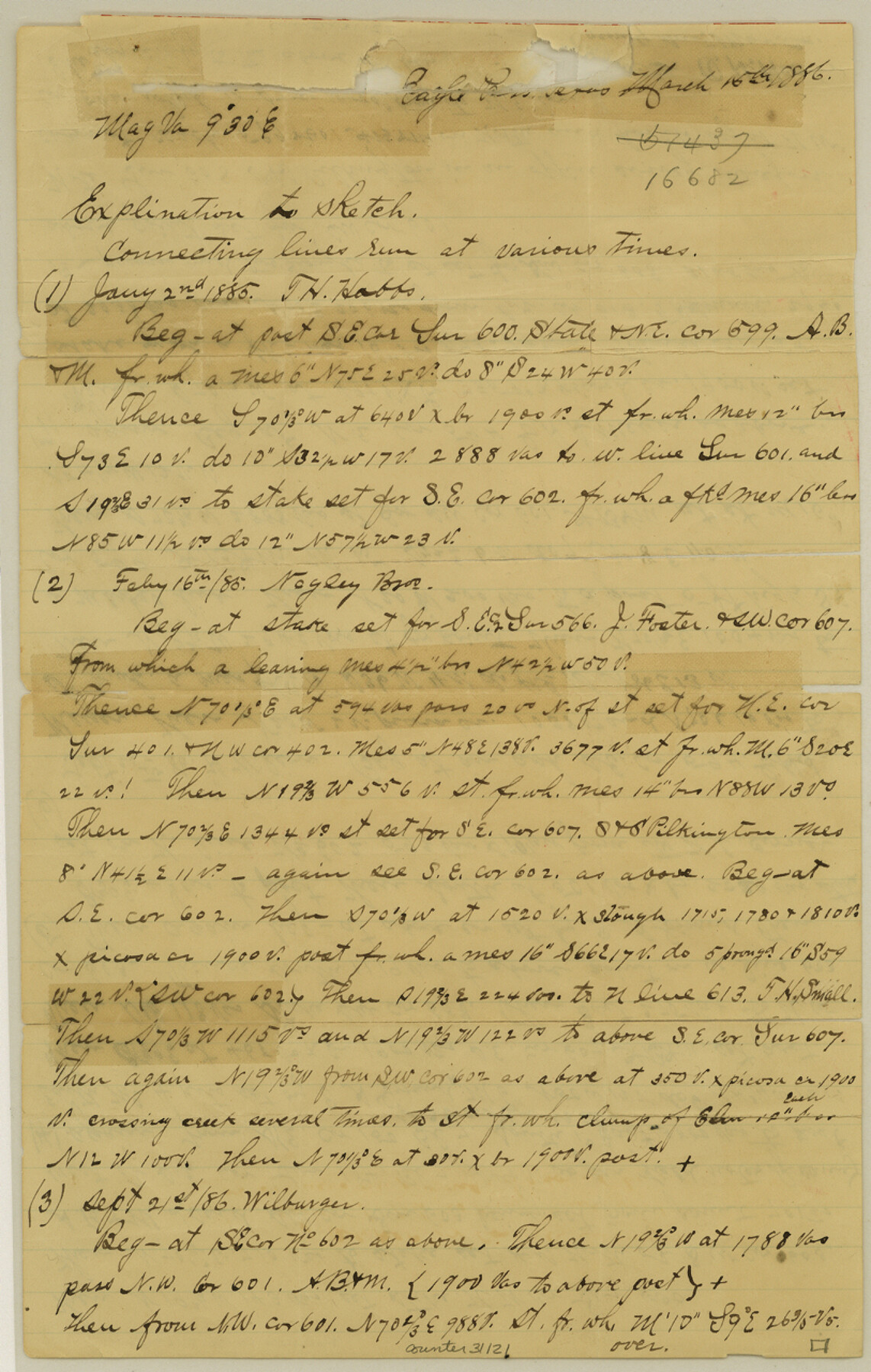
Maverick County Sketch File 18
[Sketch and explanation of area around the S. & S. Pilkington tract in the east part of the county]
-
Map/Doc
31121
-
Collection
General Map Collection
-
Object Dates
3/15/1886 (Creation Date)
7/13/1887 (File Date)
-
People and Organizations
O.H. Hector (Surveyor/Engineer)
E.A. Giraud (Surveyor/Engineer)
-
Counties
Maverick Zavala
-
Subjects
Surveying Sketch File
-
Height x Width
12.8 x 8.1 inches
32.5 x 20.6 cm
-
Medium
paper, manuscript
-
Features
Picosa Creek
Part of: General Map Collection
Gray County Working Sketch 5

Print $20.00
- Digital $50.00
Gray County Working Sketch 5
1959
Size 28.6 x 27.5 inches
Map/Doc 63236
San Patricio County Sketch File 39

Print $8.00
- Digital $50.00
San Patricio County Sketch File 39
Size 12.9 x 8.4 inches
Map/Doc 36232
Young County Boundary File 98a

Print $32.00
- Digital $50.00
Young County Boundary File 98a
Size 10.2 x 8.0 inches
Map/Doc 60211
Galveston County Rolled Sketch 45B

Print $20.00
- Digital $50.00
Galveston County Rolled Sketch 45B
1995
Size 19.8 x 29.7 inches
Map/Doc 5980
Real County Working Sketch 61

Print $20.00
- Digital $50.00
Real County Working Sketch 61
1964
Size 37.9 x 44.5 inches
Map/Doc 71953
Brooks County Working Sketch 11

Print $20.00
- Digital $50.00
Brooks County Working Sketch 11
1942
Size 41.8 x 23.5 inches
Map/Doc 67795
Comal County Sketch File 20

Print $6.00
- Digital $50.00
Comal County Sketch File 20
1857
Size 12.4 x 8.1 inches
Map/Doc 19039
Kaufman County Working Sketch 2

Print $20.00
- Digital $50.00
Kaufman County Working Sketch 2
1922
Size 19.7 x 16.5 inches
Map/Doc 66665
Aransas County Rolled Sketch 16

Digital $50.00
Aransas County Rolled Sketch 16
Size 49.9 x 97.2 inches
Map/Doc 9004
Nueces County Sketch File 16

Print $6.00
- Digital $50.00
Nueces County Sketch File 16
1875
Size 15.5 x 10.7 inches
Map/Doc 32547
Pecos County Rolled Sketch 104

Print $40.00
- Digital $50.00
Pecos County Rolled Sketch 104
Size 42.5 x 54.8 inches
Map/Doc 78197
Parker County Working Sketch 4

Print $20.00
- Digital $50.00
Parker County Working Sketch 4
1941
Map/Doc 71454
You may also like
1882 Map of the Texas & Pacific R-Y Reserve

Print $20.00
- Digital $50.00
1882 Map of the Texas & Pacific R-Y Reserve
1887
Size 44.1 x 42.1 inches
Map/Doc 83560
Frio County Sketch File 13

Print $10.00
- Digital $50.00
Frio County Sketch File 13
1948
Size 11.3 x 8.8 inches
Map/Doc 23136
[Sketch for Mineral Application 16787 - Pecos River Bed, A. T. Freet]
![65631, [Sketch for Mineral Application 16787 - Pecos River Bed, A. T. Freet], General Map Collection](https://historictexasmaps.com/wmedia_w700/maps/65631-1.tif.jpg)
Print $40.00
- Digital $50.00
[Sketch for Mineral Application 16787 - Pecos River Bed, A. T. Freet]
Size 19.6 x 70.7 inches
Map/Doc 65631
Schleicher County Sketch File 6

Print $4.00
- Digital $50.00
Schleicher County Sketch File 6
Size 8.1 x 8.5 inches
Map/Doc 36472
Pecos County Working Sketch 119

Print $20.00
- Digital $50.00
Pecos County Working Sketch 119
1973
Size 42.8 x 30.9 inches
Map/Doc 71592
Erath County Working Sketch 26

Print $20.00
- Digital $50.00
Erath County Working Sketch 26
1969
Size 20.8 x 15.0 inches
Map/Doc 69107
Map of the Missouri Pacific and St. Louis, Iron Mountain and Southern Railways and Connections

Print $20.00
- Digital $50.00
Map of the Missouri Pacific and St. Louis, Iron Mountain and Southern Railways and Connections
1893
Size 17.7 x 31.6 inches
Map/Doc 95789
Throckmorton County Rolled Sketch 3

Print $20.00
- Digital $50.00
Throckmorton County Rolled Sketch 3
1987
Size 31.2 x 36.3 inches
Map/Doc 7986
Bee County Working Sketch 31

Print $20.00
- Digital $50.00
Bee County Working Sketch 31
1929
Size 13.5 x 25.1 inches
Map/Doc 67282
Jefferson County Working Sketch 42

Print $20.00
- Digital $50.00
Jefferson County Working Sketch 42
1996
Size 31.7 x 47.2 inches
Map/Doc 66586
Kleberg County Rolled Sketch 10-23

Print $20.00
- Digital $50.00
Kleberg County Rolled Sketch 10-23
1953
Size 37.5 x 31.3 inches
Map/Doc 9396
Flight Mission No. DCL-7C, Frame 150, Kenedy County

Print $20.00
- Digital $50.00
Flight Mission No. DCL-7C, Frame 150, Kenedy County
1943
Size 18.5 x 22.2 inches
Map/Doc 86107