Mason County Sketch File 1
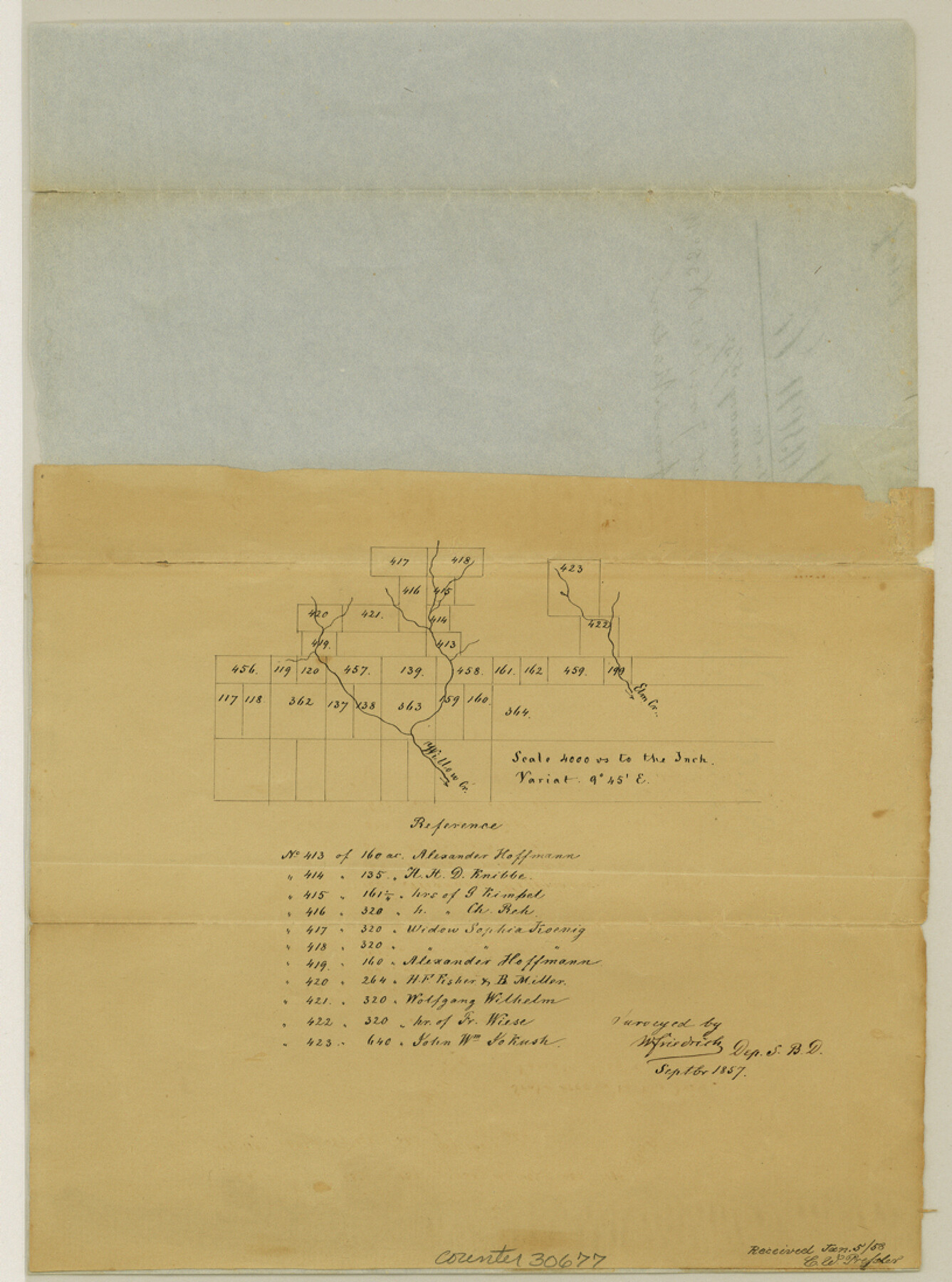
[Sketch of surveys on Elm and Willow Creeks northeast of Mason]
-
Map/Doc
30677
-
Collection
General Map Collection
-
Object Dates
9/1857 (Creation Date)
1/5/1857 (File Date)
-
People and Organizations
W. Friedrich (Surveyor/Engineer)
-
Counties
Mason
-
Subjects
Surveying Sketch File
-
Height x Width
11.0 x 8.2 inches
27.9 x 20.8 cm
-
Medium
paper, manuscript
-
Scale
1" = 4000 varas
-
Features
Elm Creek
Willow Creek
Part of: General Map Collection
Harris County Sketch File 71a

Print $24.00
- Digital $50.00
Harris County Sketch File 71a
1941
Size 11.4 x 8.9 inches
Map/Doc 25525
Nueces County Rolled Sketch 75

Print $40.00
- Digital $50.00
Nueces County Rolled Sketch 75
1945
Size 56.0 x 24.0 inches
Map/Doc 9618
Right of Way & Track Map San Antonio & Aransas Pass Railway Co.

Print $40.00
- Digital $50.00
Right of Way & Track Map San Antonio & Aransas Pass Railway Co.
1919
Size 24.8 x 55.8 inches
Map/Doc 64038
Goliad County Boundary File 33

Print $12.00
- Digital $50.00
Goliad County Boundary File 33
Size 9.4 x 4.2 inches
Map/Doc 53797
Flight Mission No. DQO-3K, Frame 24, Galveston County

Print $20.00
- Digital $50.00
Flight Mission No. DQO-3K, Frame 24, Galveston County
1952
Size 18.7 x 22.4 inches
Map/Doc 85065
Trinity River, White Rock Reservoir Sheet/White Rock Creek

Print $6.00
- Digital $50.00
Trinity River, White Rock Reservoir Sheet/White Rock Creek
1923
Size 36.3 x 16.7 inches
Map/Doc 65213
El Paso County Boundary File 7a

Print $20.00
- Digital $50.00
El Paso County Boundary File 7a
Size 14.2 x 8.3 inches
Map/Doc 53094
Flight Mission No. BRA-9M, Frame 68, Jefferson County

Print $20.00
- Digital $50.00
Flight Mission No. BRA-9M, Frame 68, Jefferson County
1953
Size 18.7 x 22.5 inches
Map/Doc 85651
Pecos County Working Sketch 87

Print $20.00
- Digital $50.00
Pecos County Working Sketch 87
1962
Size 29.0 x 31.6 inches
Map/Doc 71559
Crane County Sketch File 6

Print $20.00
- Digital $50.00
Crane County Sketch File 6
Size 18.7 x 22.8 inches
Map/Doc 11207
Collingsworth County Rolled Sketch 2A

Print $20.00
- Digital $50.00
Collingsworth County Rolled Sketch 2A
1888
Size 15.3 x 45.8 inches
Map/Doc 8638
Flight Mission No. DAG-16K, Frame 71, Matagorda County

Print $20.00
- Digital $50.00
Flight Mission No. DAG-16K, Frame 71, Matagorda County
1952
Size 16.4 x 16.4 inches
Map/Doc 86317
You may also like
Rio Grande, McAllen Sheet

Print $20.00
- Digital $50.00
Rio Grande, McAllen Sheet
1937
Size 37.4 x 37.5 inches
Map/Doc 65118
Palo Pinto County Sketch File 21

Print $20.00
- Digital $50.00
Palo Pinto County Sketch File 21
1896
Size 18.5 x 17.5 inches
Map/Doc 12133
Parker County Working Sketch 13

Print $20.00
- Digital $50.00
Parker County Working Sketch 13
1978
Map/Doc 71463
Limestone County Working Sketch 12

Print $20.00
- Digital $50.00
Limestone County Working Sketch 12
1922
Size 18.5 x 12.8 inches
Map/Doc 70562
General Highway Map, Harris County, Texas

Print $20.00
General Highway Map, Harris County, Texas
1961
Size 24.9 x 18.0 inches
Map/Doc 79502
Dimmit County Working Sketch 37

Print $20.00
- Digital $50.00
Dimmit County Working Sketch 37
1962
Size 28.9 x 25.6 inches
Map/Doc 68698
Nueces County NRC Article 33.136 Sketch 5

Print $48.00
- Digital $50.00
Nueces County NRC Article 33.136 Sketch 5
2002
Size 22.9 x 34.7 inches
Map/Doc 78666
Cass County Working Sketch 13

Print $20.00
- Digital $50.00
Cass County Working Sketch 13
1945
Size 29.8 x 33.5 inches
Map/Doc 67916
Hockley County Sketch File 4

Print $6.00
- Digital $50.00
Hockley County Sketch File 4
Size 9.1 x 11.2 inches
Map/Doc 26536
Zavala County

Print $40.00
- Digital $50.00
Zavala County
1977
Size 43.9 x 49.2 inches
Map/Doc 73334
Refugio County

Print $20.00
- Digital $50.00
Refugio County
1872
Size 17.6 x 22.9 inches
Map/Doc 3987
Travis County Working Sketch 67

Print $20.00
- Digital $50.00
Travis County Working Sketch 67
2017
Size 24.6 x 36.6 inches
Map/Doc 94123