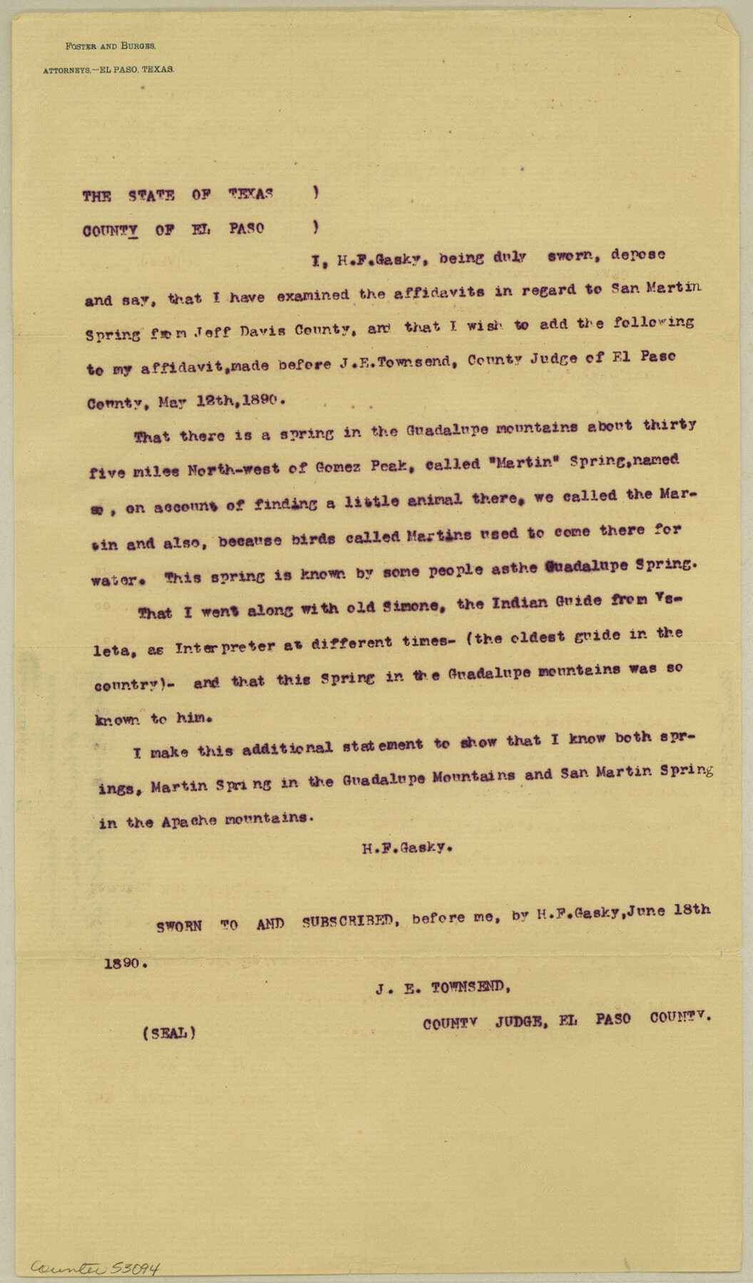
El Paso County Boundary File 7a
Testimony of Gasky placing San Martin Springs South of TPRR
-
Map/Doc
53094
-
Collection
General Map Collection
-
Counties
El Paso
-
Subjects
County Boundaries
-
Height x Width
14.2 x 8.3 inches
36.1 x 21.1 cm
Part of: General Map Collection

Brazoria County Working Sketch 2

Print $20.00
- Digital $50.00
Brazoria County Working Sketch 2
1907
Size 20.9 x 20.8 inches
Map/Doc 67487
![94186, Texas [Verso], General Map Collection](https://historictexasmaps.com/wmedia_w700/maps/94186.tif.jpg)
Working Sketch Patents & Field Notes, Sabine Lake Area

Print $20.00
- Digital $50.00
Working Sketch Patents & Field Notes, Sabine Lake Area
1959
Size 30.2 x 27.0 inches
Map/Doc 2455
Maps of Gulf Intracoastal Waterway, Texas - Sabine River to the Rio Grande and connecting waterways including ship channels

Print $20.00
- Digital $50.00
Maps of Gulf Intracoastal Waterway, Texas - Sabine River to the Rio Grande and connecting waterways including ship channels
1966
Size 14.6 x 22.2 inches
Map/Doc 61979
Angelina County Working Sketch 21

Print $20.00
- Digital $50.00
Angelina County Working Sketch 21
1947
Size 35.7 x 35.8 inches
Map/Doc 67102
Map of Galveston County

Print $20.00
- Digital $50.00
Map of Galveston County
1883
Size 18.8 x 26.8 inches
Map/Doc 3573
Supreme Court of the United States, October Term, 1924, No. 13, Original - The State of Oklahoma, Complainant vs. The State of Texas, Defendant, The United States, Intervener

Print $20.00
- Digital $50.00
Supreme Court of the United States, October Term, 1924, No. 13, Original - The State of Oklahoma, Complainant vs. The State of Texas, Defendant, The United States, Intervener
1924
Size 32.0 x 32.8 inches
Map/Doc 75132
Burleson County Sketch File 8

Print $6.00
- Digital $50.00
Burleson County Sketch File 8
Size 8.7 x 5.3 inches
Map/Doc 16654
Maps of Gulf Intracoastal Waterway, Texas - Sabine River to the Rio Grande and connecting waterways including ship channels

Print $20.00
- Digital $50.00
Maps of Gulf Intracoastal Waterway, Texas - Sabine River to the Rio Grande and connecting waterways including ship channels
1966
Size 14.5 x 22.3 inches
Map/Doc 61948
San Saba County Working Sketch Graphic Index

Print $20.00
- Digital $50.00
San Saba County Working Sketch Graphic Index
1918
Size 46.5 x 41.1 inches
Map/Doc 76693
Reagan County Working Sketch 40

Print $20.00
- Digital $50.00
Reagan County Working Sketch 40
1973
Size 31.7 x 28.6 inches
Map/Doc 71882
You may also like
Hopkins County Sketch File 9

Print $6.00
- Digital $50.00
Hopkins County Sketch File 9
1856
Size 12.8 x 8.3 inches
Map/Doc 26697
[Southwest Portion of Lynn County, Southeast Portion of Terry County]
![91305, [Southwest Portion of Lynn County, Southeast Portion of Terry County], Twichell Survey Records](https://historictexasmaps.com/wmedia_w700/maps/91305-1.tif.jpg)
Print $20.00
- Digital $50.00
[Southwest Portion of Lynn County, Southeast Portion of Terry County]
1952
Size 34.3 x 35.1 inches
Map/Doc 91305
Brazoria County Sketch File 1a

Print $6.00
- Digital $50.00
Brazoria County Sketch File 1a
1861
Size 12.5 x 11.5 inches
Map/Doc 14918
Flight Mission No. CUG-3P, Frame 168, Kleberg County

Print $20.00
- Digital $50.00
Flight Mission No. CUG-3P, Frame 168, Kleberg County
1956
Size 18.6 x 22.3 inches
Map/Doc 86288
Harris County Working Sketch 85

Print $20.00
- Digital $50.00
Harris County Working Sketch 85
1971
Size 41.5 x 44.0 inches
Map/Doc 65977
Zavala County Working Sketch 11

Print $20.00
- Digital $50.00
Zavala County Working Sketch 11
1955
Size 13.8 x 22.4 inches
Map/Doc 62086
Henderson County Boundary File 2a

Print $12.00
- Digital $50.00
Henderson County Boundary File 2a
Size 14.2 x 8.8 inches
Map/Doc 54656
Glasscock County Working Sketch 8

Print $40.00
- Digital $50.00
Glasscock County Working Sketch 8
1955
Size 43.5 x 120.3 inches
Map/Doc 63181
Plan of Driving Park Addition composed of Out-lots 37, 38, 39, 49, 50, 60, & 61, Division "O" in the City of Austin

Print $20.00
- Digital $50.00
Plan of Driving Park Addition composed of Out-lots 37, 38, 39, 49, 50, 60, & 61, Division "O" in the City of Austin
1910
Size 18.4 x 15.9 inches
Map/Doc 2024
[Blocks C22, C23, C24, 77, B3, B5, 26, 27, 74, 75]
![91973, [Blocks C22, C23, C24, 77, B3, B5, 26, 27, 74, 75], Twichell Survey Records](https://historictexasmaps.com/wmedia_w700/maps/91973-1.tif.jpg)
Print $20.00
- Digital $50.00
[Blocks C22, C23, C24, 77, B3, B5, 26, 27, 74, 75]
Size 21.9 x 16.9 inches
Map/Doc 91973
Baylor County Sketch File 32

Print $10.00
- Digital $50.00
Baylor County Sketch File 32
Size 10.2 x 8.2 inches
Map/Doc 14238
Angelina County Sketch File 18

Print $4.00
- Digital $50.00
Angelina County Sketch File 18
Size 8.6 x 3.9 inches
Map/Doc 13028