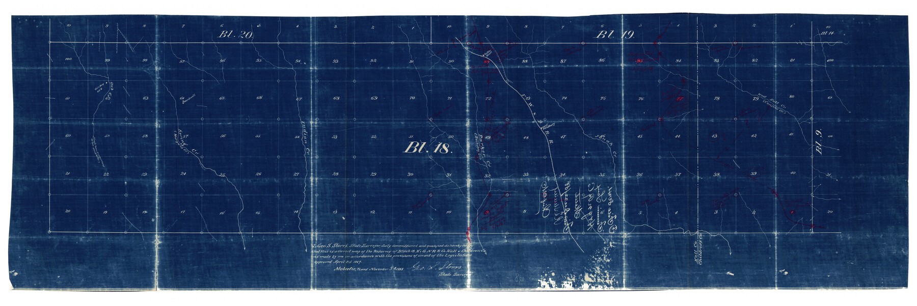
Collingsworth County Rolled Sketch 2A
[Resurvey of Block 18, H. & G. N. R.R. Co.]
-
Map/Doc
8638
-
Collection
General Map Collection
-
Object Dates
1888/11/30 (Creation Date)
1945/4/12 (File Date)
-
People and Organizations
Geo. S. Storrs (Surveyor/Engineer)
-
Counties
Childress Hall
-
Subjects
Surveying Rolled Sketch
-
Height x Width
15.3 x 45.8 inches
38.9 x 116.3 cm
-
Medium
blueprint/diazo
Part of: General Map Collection
Trinity River, Allison Sheet/Denton Creek

Print $4.00
- Digital $50.00
Trinity River, Allison Sheet/Denton Creek
1928
Size 26.3 x 24.2 inches
Map/Doc 65223
Galveston County NRC Article 33.136 Sketch 19

Print $50.00
- Digital $50.00
Galveston County NRC Article 33.136 Sketch 19
2002
Size 37.1 x 25.4 inches
Map/Doc 78491
Gonzales County

Print $40.00
- Digital $50.00
Gonzales County
1986
Size 41.6 x 54.7 inches
Map/Doc 73160
Ochiltree County Boundary File 1a

Print $4.00
- Digital $50.00
Ochiltree County Boundary File 1a
Size 11.0 x 8.5 inches
Map/Doc 57664
Bandera County Sketch File 2

Print $4.00
- Digital $50.00
Bandera County Sketch File 2
1855
Size 7.1 x 7.9 inches
Map/Doc 13997
Fort Bend County Rolled Sketch 2

Print $20.00
- Digital $50.00
Fort Bend County Rolled Sketch 2
1954
Size 24.4 x 28.6 inches
Map/Doc 5892
Flight Mission No. CRC-6R, Frame 37, Chambers County

Print $20.00
- Digital $50.00
Flight Mission No. CRC-6R, Frame 37, Chambers County
1956
Size 18.5 x 22.4 inches
Map/Doc 84970
Revised Map of Matagorda Bay and Vicinity in Matagorda and Calhoun Counties showing subdivision for mineral development

Print $40.00
- Digital $50.00
Revised Map of Matagorda Bay and Vicinity in Matagorda and Calhoun Counties showing subdivision for mineral development
1941
Size 44.3 x 60.0 inches
Map/Doc 2933
Upton County Sketch File 14CF

Print $8.00
- Digital $50.00
Upton County Sketch File 14CF
1926
Size 11.3 x 8.8 inches
Map/Doc 38860
Navigation Maps of Gulf Intracoastal Waterway, Port Arthur to Brownsville, Texas

Print $4.00
- Digital $50.00
Navigation Maps of Gulf Intracoastal Waterway, Port Arthur to Brownsville, Texas
1951
Size 16.7 x 21.5 inches
Map/Doc 65441
Falls County Rolled Sketch 1

Print $73.00
- Digital $50.00
Falls County Rolled Sketch 1
1934
Size 10.6 x 15.1 inches
Map/Doc 44540
Liberty County Working Sketch 52

Print $20.00
- Digital $50.00
Liberty County Working Sketch 52
1956
Size 32.5 x 24.6 inches
Map/Doc 70512
You may also like
Flight Mission No. DCL-7C, Frame 53, Kenedy County

Print $20.00
- Digital $50.00
Flight Mission No. DCL-7C, Frame 53, Kenedy County
1943
Size 16.7 x 16.4 inches
Map/Doc 86041
Sketch in Block 9, Potter County Texas

Print $20.00
- Digital $50.00
Sketch in Block 9, Potter County Texas
1945
Size 15.7 x 18.5 inches
Map/Doc 91719

DeWitt County

Print $40.00
- Digital $50.00
DeWitt County
1987
Size 41.4 x 49.9 inches
Map/Doc 77263
Maps of Gulf Intracoastal Waterway, Texas - Sabine River to the Rio Grande and connecting waterways including ship channels

Print $20.00
- Digital $50.00
Maps of Gulf Intracoastal Waterway, Texas - Sabine River to the Rio Grande and connecting waterways including ship channels
1966
Size 14.6 x 22.2 inches
Map/Doc 61975
[Sketch for Mineral Application 13436 - Cut-off Bayou]
![65675, [Sketch for Mineral Application 13436 - Cut-off Bayou], General Map Collection](https://historictexasmaps.com/wmedia_w700/maps/65675-1.tif.jpg)
Print $20.00
- Digital $50.00
[Sketch for Mineral Application 13436 - Cut-off Bayou]
1928
Size 21.3 x 44.3 inches
Map/Doc 65675
Calhoun County Rolled Sketch 36

Print $40.00
- Digital $50.00
Calhoun County Rolled Sketch 36
2003
Size 33.3 x 49.0 inches
Map/Doc 78655
Map of The Surveyed Part of Peters Colony Texas

Print $40.00
- Digital $50.00
Map of The Surveyed Part of Peters Colony Texas
1854
Size 53.5 x 65.9 inches
Map/Doc 1967
Frio County Sketch File 21

Print $20.00
- Digital $50.00
Frio County Sketch File 21
1938
Size 23.4 x 24.3 inches
Map/Doc 11520
Upton County Rolled Sketch 39

Print $40.00
- Digital $50.00
Upton County Rolled Sketch 39
Size 53.4 x 44.1 inches
Map/Doc 10055
[Sketch showing Blocks 5, M-20, 22 and strip of Block BB]
![91723, [Sketch showing Blocks 5, M-20, 22 and strip of Block BB], Twichell Survey Records](https://historictexasmaps.com/wmedia_w700/maps/91723-1.tif.jpg)
Print $2.00
- Digital $50.00
[Sketch showing Blocks 5, M-20, 22 and strip of Block BB]
Size 7.1 x 10.4 inches
Map/Doc 91723
Flight Mission No. DQN-5K, Frame 40, Calhoun County

Print $20.00
- Digital $50.00
Flight Mission No. DQN-5K, Frame 40, Calhoun County
1953
Size 18.6 x 22.1 inches
Map/Doc 84388