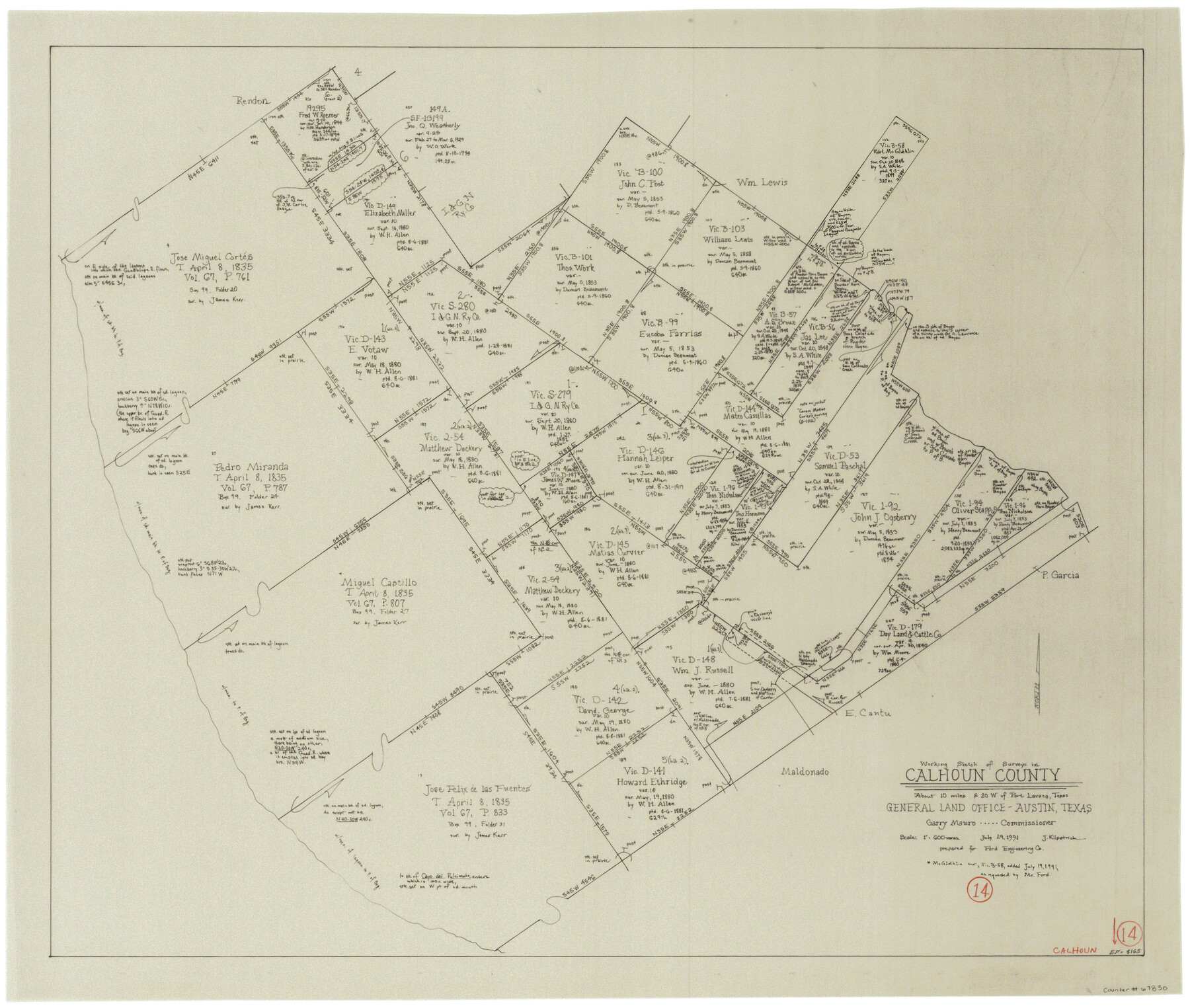
Calhoun County Working Sketch 14
-
Map/Doc
67830
-
Collection
General Map Collection
-
Object Dates
7/19/1991 (Creation Date)
-
People and Organizations
Joan Kilpatrick (Draftsman)
-
Counties
Calhoun
-
Subjects
Surveying Working Sketch
-
Height x Width
28.7 x 33.9 inches
72.9 x 86.1 cm
-
Scale
1" = 600 varas
Part of: General Map Collection
Jack County Working Sketch 1

Print $20.00
- Digital $50.00
Jack County Working Sketch 1
Size 28.4 x 27.1 inches
Map/Doc 66427
Reagan County Sketch File 34

Print $4.00
- Digital $50.00
Reagan County Sketch File 34
Size 11.5 x 8.9 inches
Map/Doc 35030
Gillespie County Sketch File 6

Print $4.00
- Digital $50.00
Gillespie County Sketch File 6
Size 6.4 x 11.0 inches
Map/Doc 24139
Flight Mission No. DQN-2K, Frame 84, Calhoun County

Print $20.00
- Digital $50.00
Flight Mission No. DQN-2K, Frame 84, Calhoun County
1953
Size 18.5 x 22.2 inches
Map/Doc 84274
Briscoe County Sketch File M

Print $40.00
- Digital $50.00
Briscoe County Sketch File M
Size 36.1 x 28.0 inches
Map/Doc 11010
Texas map showing principal forts

Print $20.00
- Digital $50.00
Texas map showing principal forts
1852
Size 34.7 x 25.1 inches
Map/Doc 2125
Upton County Rolled Sketch 59A

Print $20.00
- Digital $50.00
Upton County Rolled Sketch 59A
Size 35.5 x 46.3 inches
Map/Doc 76424
Van Zandt County Sketch File 17 and 17a

Print $6.00
- Digital $50.00
Van Zandt County Sketch File 17 and 17a
1858
Size 14.2 x 8.1 inches
Map/Doc 39417
Boundary Between the United States & Mexico Agreed upon by the Joint Commission under the Treaty of Guadalupe Hidalgo

Print $20.00
- Digital $50.00
Boundary Between the United States & Mexico Agreed upon by the Joint Commission under the Treaty of Guadalupe Hidalgo
1853
Size 18.4 x 26.5 inches
Map/Doc 72884
Matagorda County Working Sketch 7

Print $20.00
- Digital $50.00
Matagorda County Working Sketch 7
1953
Size 41.0 x 31.8 inches
Map/Doc 70865
Chambers County Sketch File 18b

Print $15.00
- Digital $50.00
Chambers County Sketch File 18b
1901
Size 9.2 x 8.1 inches
Map/Doc 17571
Fannin County Sketch File 25

Print $4.00
- Digital $50.00
Fannin County Sketch File 25
1847
Size 8.5 x 10.9 inches
Map/Doc 22493
You may also like
Panola County

Print $20.00
- Digital $50.00
Panola County
1947
Size 41.7 x 41.3 inches
Map/Doc 95607
Edwards County Sketch File 12c

Print $20.00
- Digital $50.00
Edwards County Sketch File 12c
Size 23.0 x 26.8 inches
Map/Doc 11425
Grayson County Boundary File 4a

Print $24.00
- Digital $50.00
Grayson County Boundary File 4a
Size 10.0 x 42.7 inches
Map/Doc 53956
Montague County Rolled Sketch 8

Print $20.00
- Digital $50.00
Montague County Rolled Sketch 8
Size 25.4 x 21.8 inches
Map/Doc 6792

Dimmit County Working Sketch 58

Print $20.00
- Digital $50.00
Dimmit County Working Sketch 58
2017
Size 24.2 x 36.2 inches
Map/Doc 94121
United States

Print $20.00
- Digital $50.00
United States
1851
Size 10.8 x 15.1 inches
Map/Doc 93799

[Pecos River Bed]
![2467, [Pecos River Bed], General Map Collection](https://historictexasmaps.com/wmedia_w700/maps/2467.tif.jpg)
Print $20.00
- Digital $50.00
[Pecos River Bed]
Size 16.6 x 39.8 inches
Map/Doc 2467
[Blocks M1 and 3T]
![91515, [Blocks M1 and 3T], Twichell Survey Records](https://historictexasmaps.com/wmedia_w700/maps/91515-1.tif.jpg)
Print $20.00
- Digital $50.00
[Blocks M1 and 3T]
Size 10.1 x 26.3 inches
Map/Doc 91515
Kent County Boundary File 7

Print $6.00
- Digital $50.00
Kent County Boundary File 7
Size 10.8 x 8.7 inches
Map/Doc 55870
Crockett County Working Sketch 26

Print $20.00
- Digital $50.00
Crockett County Working Sketch 26
1922
Size 15.3 x 20.3 inches
Map/Doc 68359