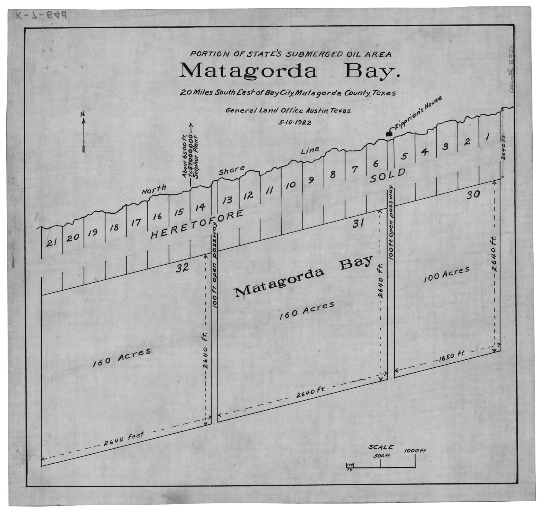
Portion of States Submerged Area in Matagorda Bay
K-7-64 (a-h)
-
Map/Doc
2952
-
Collection
General Map Collection
-
Object Dates
5/10/1922 (Creation Date)
-
Counties
Matagorda
-
Subjects
Energy Offshore Submerged Area
-
Height x Width
13.9 x 14.7 inches
35.3 x 37.3 cm
Part of: General Map Collection
[Map of Zapata County]
![4178, [Map of Zapata County], General Map Collection](https://historictexasmaps.com/wmedia_w700/maps/4178.tif.jpg)
Print $20.00
- Digital $50.00
[Map of Zapata County]
1883
Size 20.5 x 20.9 inches
Map/Doc 4178
Hudspeth County Working Sketch 6

Print $20.00
- Digital $50.00
Hudspeth County Working Sketch 6
1920
Size 19.5 x 20.1 inches
Map/Doc 66287
Jefferson County Sketch File 23

Print $20.00
- Digital $50.00
Jefferson County Sketch File 23
Size 15.8 x 17.8 inches
Map/Doc 11871
Orange County Rolled Sketch 18

Print $20.00
- Digital $50.00
Orange County Rolled Sketch 18
Size 11.6 x 12.6 inches
Map/Doc 7182
Harris County Sketch File 66

Print $20.00
- Digital $50.00
Harris County Sketch File 66
Size 16.9 x 27.5 inches
Map/Doc 11661
Roberts County Working Sketch 21

Print $20.00
- Digital $50.00
Roberts County Working Sketch 21
1979
Size 35.7 x 45.6 inches
Map/Doc 63547
Frio County Working Sketch 15

Print $20.00
- Digital $50.00
Frio County Working Sketch 15
1961
Size 31.2 x 43.5 inches
Map/Doc 69289
Flight Mission No. DCL-7C, Frame 78, Kenedy County

Print $20.00
- Digital $50.00
Flight Mission No. DCL-7C, Frame 78, Kenedy County
1943
Size 15.3 x 15.2 inches
Map/Doc 86064
Hudspeth County Working Sketch 54

Print $20.00
- Digital $50.00
Hudspeth County Working Sketch 54
1989
Size 18.8 x 36.2 inches
Map/Doc 66339

Kenedy County Rolled Sketch 16

Print $40.00
- Digital $50.00
Kenedy County Rolled Sketch 16
1978
Size 36.7 x 50.2 inches
Map/Doc 10693
Map of Brazoria County

Print $20.00
- Digital $50.00
Map of Brazoria County
1883
Size 26.8 x 25.6 inches
Map/Doc 861
You may also like
General Highway Map, Hardeman County, Texas

Print $20.00
General Highway Map, Hardeman County, Texas
1961
Size 24.6 x 18.1 inches
Map/Doc 79498
The Making of America - The Southwest

The Making of America - The Southwest
Size 20.8 x 27.5 inches
Map/Doc 95947
[Blocks 10T, O7, S2, S3, T2, T3, JB and A]
![89953, [Blocks 10T, O7, S2, S3, T2, T3, JB and A], Twichell Survey Records](https://historictexasmaps.com/wmedia_w700/maps/89953-1.tif.jpg)
Print $20.00
- Digital $50.00
[Blocks 10T, O7, S2, S3, T2, T3, JB and A]
Size 41.8 x 37.7 inches
Map/Doc 89953
Potter County Sketch File 3

Print $20.00
- Digital $50.00
Potter County Sketch File 3
1883
Size 37.5 x 47.6 inches
Map/Doc 10574
Dickens County Sketch File 21

Print $20.00
- Digital $50.00
Dickens County Sketch File 21
1911
Size 16.0 x 12.8 inches
Map/Doc 11324
Map of the State of Texas [West Part]
![81921, Map of the State of Texas [West Part], General Map Collection](https://historictexasmaps.com/wmedia_w700/maps/81921.tif.jpg)
Print $40.00
- Digital $50.00
Map of the State of Texas [West Part]
1938
Size 68.7 x 38.2 inches
Map/Doc 81921
Rusk County Sketch File 20

Print $4.00
Rusk County Sketch File 20
1859
Size 10.2 x 8.1 inches
Map/Doc 35530
Sketch of part of Brazos Island

Print $20.00
- Digital $50.00
Sketch of part of Brazos Island
1863
Size 25.1 x 18.2 inches
Map/Doc 72923
Southern Pacific Transportation Company Right of Way and Track Map - Main Line

Print $40.00
- Digital $50.00
Southern Pacific Transportation Company Right of Way and Track Map - Main Line
1918
Size 25.4 x 57.6 inches
Map/Doc 82858

Right of Way and Track Map Texas & New Orleans R.R. Co. operated by the T. & N. O. R.R. Co. Dallas-Sabine Branch

Print $40.00
- Digital $50.00
Right of Way and Track Map Texas & New Orleans R.R. Co. operated by the T. & N. O. R.R. Co. Dallas-Sabine Branch
1918
Size 26.8 x 56.7 inches
Map/Doc 64151
Tyler County Sketch File 17b

Print $4.00
- Digital $50.00
Tyler County Sketch File 17b
Size 12.0 x 8.0 inches
Map/Doc 38666