Kaufman County Sketch File 18
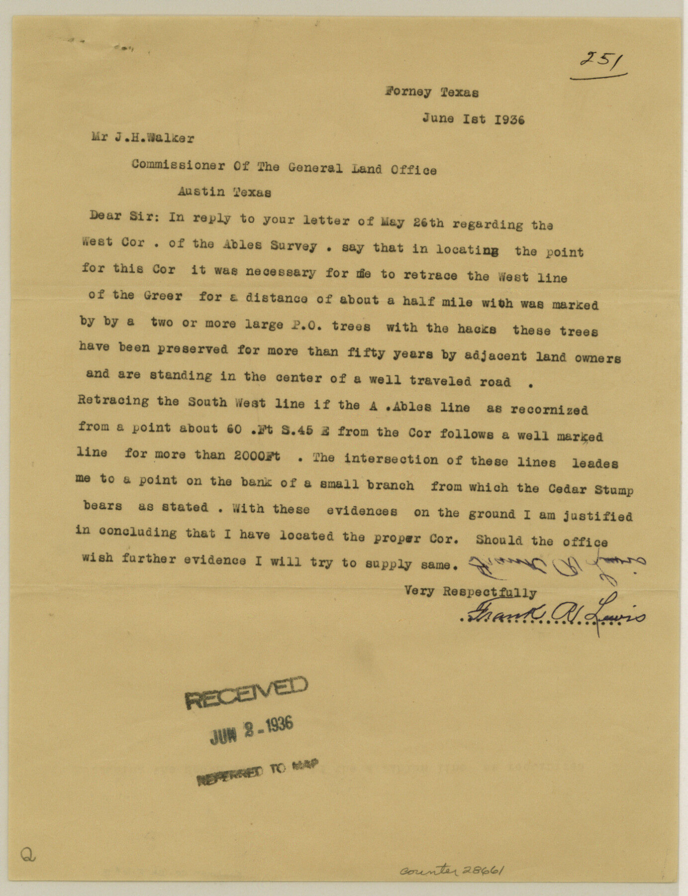
[Correspondence and affidavit regarding location of west corner of the Ables survey no. 86]
-
Map/Doc
28661
-
Collection
General Map Collection
-
Object Dates
6/1/1936 (Creation Date)
6/2/1936 (File Date)
5/26/1936 (Correspondence Date)
5/23/1936 (Correspondence Date)
5/1936 (Survey Date)
-
People and Organizations
Frank R. Lewis (Surveyor/Engineer)
-
Counties
Kaufman
-
Subjects
Surveying Sketch File
-
Height x Width
11.4 x 8.8 inches
29.0 x 22.4 cm
-
Medium
paper, print
Part of: General Map Collection
Hidalgo County Sketch File 14

Print $20.00
- Digital $50.00
Hidalgo County Sketch File 14
Size 29.6 x 24.5 inches
Map/Doc 11764
El Paso County Rolled Sketch LH

Print $20.00
- Digital $50.00
El Paso County Rolled Sketch LH
1890
Size 20.3 x 31.7 inches
Map/Doc 5858
Stephens County Working Sketch 24

Print $20.00
- Digital $50.00
Stephens County Working Sketch 24
1976
Size 39.2 x 31.9 inches
Map/Doc 63967
Zapata County Working Sketch Graphic Index, Sheet 2 (Sketches 19 to Most Recent)

Print $40.00
- Digital $50.00
Zapata County Working Sketch Graphic Index, Sheet 2 (Sketches 19 to Most Recent)
1935
Size 55.6 x 41.5 inches
Map/Doc 76750
DeWitt County Sketch File 4

Print $4.00
- Digital $50.00
DeWitt County Sketch File 4
1872
Size 8.3 x 13.1 inches
Map/Doc 20801
Hutchinson County Rolled Sketch 9

Print $20.00
- Digital $50.00
Hutchinson County Rolled Sketch 9
Size 25.5 x 27.8 inches
Map/Doc 6280
Grayson County Sketch File 21

Print $14.00
- Digital $50.00
Grayson County Sketch File 21
Size 7.7 x 17.8 inches
Map/Doc 24495
Flight Mission No. BQY-4M, Frame 115, Harris County

Print $20.00
- Digital $50.00
Flight Mission No. BQY-4M, Frame 115, Harris County
1953
Size 18.6 x 22.5 inches
Map/Doc 85282
Map of Bexar County

Print $40.00
- Digital $50.00
Map of Bexar County
1845
Size 49.0 x 46.5 inches
Map/Doc 87236
Pecos County Rolled Sketch JAS

Print $20.00
- Digital $50.00
Pecos County Rolled Sketch JAS
1937
Size 34.9 x 31.4 inches
Map/Doc 9744
Flight Mission No. DAG-23K, Frame 187, Matagorda County

Print $20.00
- Digital $50.00
Flight Mission No. DAG-23K, Frame 187, Matagorda County
1953
Size 17.5 x 22.4 inches
Map/Doc 86522
Kent County Sketch File 13

Print $6.00
- Digital $50.00
Kent County Sketch File 13
1921
Size 11.1 x 8.7 inches
Map/Doc 28839
You may also like
Amistad International Reservoir on Rio Grande 66

Print $20.00
- Digital $50.00
Amistad International Reservoir on Rio Grande 66
1949
Size 28.5 x 39.6 inches
Map/Doc 73351
Bandera County Sketch File 6

Print $4.00
- Digital $50.00
Bandera County Sketch File 6
1877
Size 8.0 x 12.7 inches
Map/Doc 14005
[Capitol Leagues in Lamb County]
![91015, [Capitol Leagues in Lamb County], Twichell Survey Records](https://historictexasmaps.com/wmedia_w700/maps/91015-1.tif.jpg)
Print $2.00
- Digital $50.00
[Capitol Leagues in Lamb County]
1912
Size 12.3 x 8.8 inches
Map/Doc 91015
Maps & Lists Showing Prison Lands (Oil & Gas) Leased as of June 1955

Digital $50.00
Maps & Lists Showing Prison Lands (Oil & Gas) Leased as of June 1955
Size 11.4 x 7.1 inches
Map/Doc 62866
Map of east portion of Matagorda Bay in Matagorda County showing subdivision for mineral development

Print $40.00
- Digital $50.00
Map of east portion of Matagorda Bay in Matagorda County showing subdivision for mineral development
Size 33.0 x 52.8 inches
Map/Doc 65809
Houston County Working Sketch 1

Print $20.00
- Digital $50.00
Houston County Working Sketch 1
Size 20.6 x 15.6 inches
Map/Doc 66231
Starr County Rolled Sketch 8

Print $20.00
- Digital $50.00
Starr County Rolled Sketch 8
Size 21.5 x 29.6 inches
Map/Doc 7796

McMullen County Working Sketch 30

Print $40.00
- Digital $50.00
McMullen County Working Sketch 30
1957
Size 41.4 x 50.8 inches
Map/Doc 70731
Midland County Sketch File 2

Print $20.00
- Digital $50.00
Midland County Sketch File 2
1886
Size 16.3 x 17.6 inches
Map/Doc 12080
Aransas County NRC Article 33.136 Sketch 13

Print $24.00
- Digital $50.00
Aransas County NRC Article 33.136 Sketch 13
Size 24.0 x 36.0 inches
Map/Doc 94514
Webb County Working Sketch 74

Print $20.00
- Digital $50.00
Webb County Working Sketch 74
1975
Size 17.0 x 30.0 inches
Map/Doc 72441