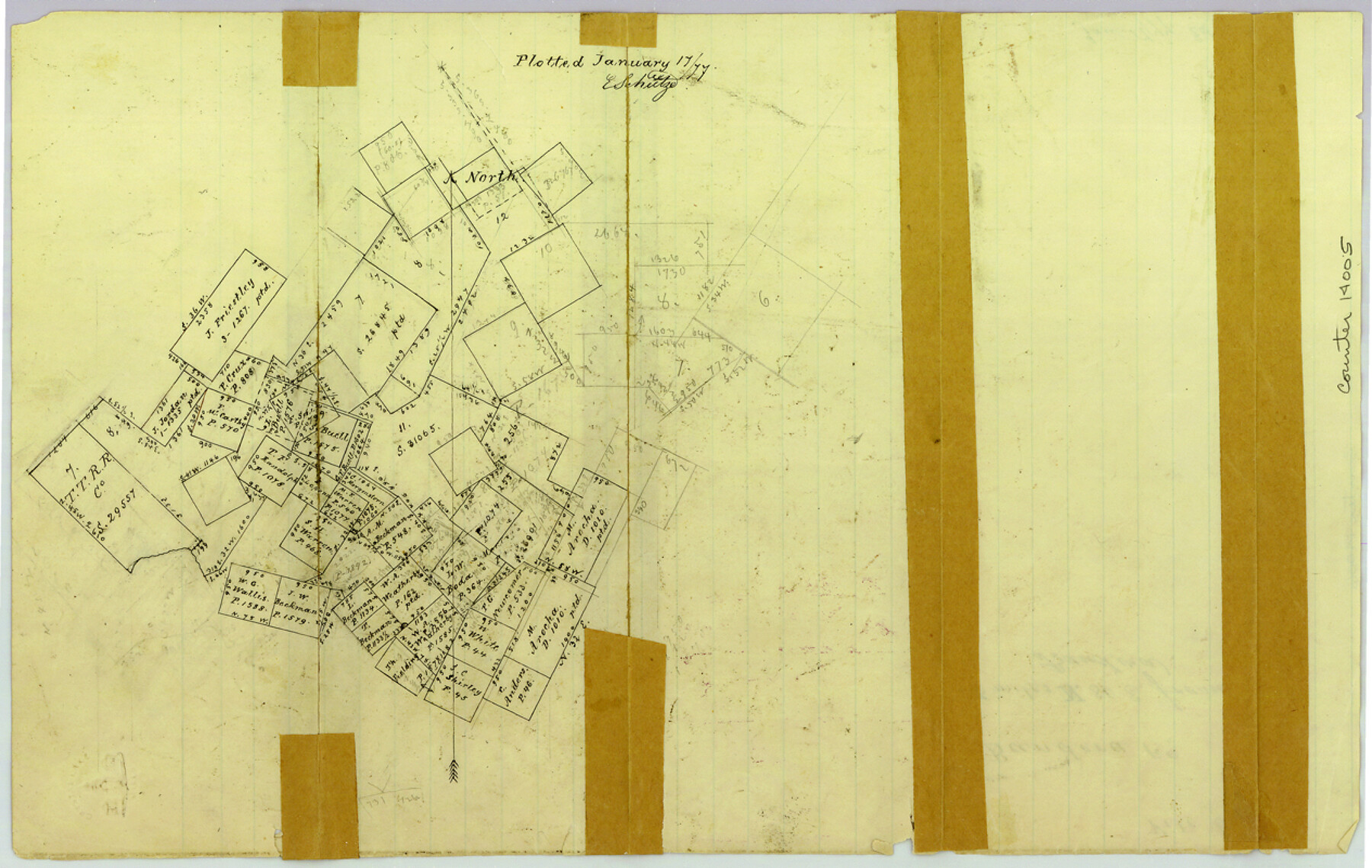
Bandera County Sketch File 6
[Office sketch of area east of Bandera]
-
Map/Doc
14005
-
Collection
General Map Collection
-
Object Dates
1877/1/17 (Creation Date)
-
People and Organizations
E. Schutze (Draftsman)
-
Counties
Bandera
-
Subjects
Surveying Sketch File
-
Height x Width
8.0 x 12.7 inches
20.3 x 32.3 cm
-
Medium
paper, manuscript
Part of: General Map Collection
Presidio County Working Sketch 39

Print $20.00
- Digital $50.00
Presidio County Working Sketch 39
1948
Size 44.6 x 43.4 inches
Map/Doc 71716
Victoria County Working Sketch 8

Print $20.00
- Digital $50.00
Victoria County Working Sketch 8
1957
Size 25.9 x 37.8 inches
Map/Doc 72278
Brooks County Boundary File 2

Print $8.00
- Digital $50.00
Brooks County Boundary File 2
Size 8.6 x 11.3 inches
Map/Doc 50839
Asher & Adams' Geological Map - United States and Territories

Print $20.00
- Digital $50.00
Asher & Adams' Geological Map - United States and Territories
Size 17.9 x 24.9 inches
Map/Doc 95175
Sutton County Sketch File 42

Print $6.00
- Digital $50.00
Sutton County Sketch File 42
1940
Size 11.2 x 8.8 inches
Map/Doc 37509
Starr County Rolled Sketch 43

Print $20.00
- Digital $50.00
Starr County Rolled Sketch 43
1982
Size 36.1 x 30.9 inches
Map/Doc 7836
Montgomery County Sketch File 40

Print $8.00
- Digital $50.00
Montgomery County Sketch File 40
1914
Size 11.3 x 8.8 inches
Map/Doc 31925
Kimble County Sketch File C

Print $4.00
- Digital $50.00
Kimble County Sketch File C
Size 14.9 x 7.5 inches
Map/Doc 28965
Val Verde County Sketch File 8

Print $38.00
- Digital $50.00
Val Verde County Sketch File 8
1885
Size 22.6 x 23.2 inches
Map/Doc 12564
Polk County Sketch File 8

Print $4.00
- Digital $50.00
Polk County Sketch File 8
1859
Size 10.9 x 8.4 inches
Map/Doc 34134
Potter County Working Sketch 3

Print $20.00
- Digital $50.00
Potter County Working Sketch 3
1920
Size 42.1 x 16.8 inches
Map/Doc 71663
Galveston County Working Sketch 9

Print $20.00
- Digital $50.00
Galveston County Working Sketch 9
1948
Size 31.9 x 25.8 inches
Map/Doc 69346
You may also like
Cass County Working Sketch 33

Print $20.00
- Digital $50.00
Cass County Working Sketch 33
1982
Size 27.4 x 26.6 inches
Map/Doc 67936
Stonewall County Sketch File 22

Print $20.00
- Digital $50.00
Stonewall County Sketch File 22
1937
Size 18.8 x 23.1 inches
Map/Doc 12368
Taylor County Working Sketch 8

Print $40.00
- Digital $50.00
Taylor County Working Sketch 8
1953
Size 73.2 x 43.1 inches
Map/Doc 69618
Corrected Map of Burnet County or Northern District of Houston County

Print $20.00
- Digital $50.00
Corrected Map of Burnet County or Northern District of Houston County
1845
Size 32.0 x 19.9 inches
Map/Doc 5052
Tahoka Heights Addition to Tahoka Located on the SE Quarter of Section 568

Print $20.00
- Digital $50.00
Tahoka Heights Addition to Tahoka Located on the SE Quarter of Section 568
Size 18.1 x 18.5 inches
Map/Doc 92939
Tarrant County Working Sketch 10

Print $40.00
- Digital $50.00
Tarrant County Working Sketch 10
1986
Size 29.4 x 58.0 inches
Map/Doc 62427
[Surveys in Liberty County]
![69750, [Surveys in Liberty County], General Map Collection](https://historictexasmaps.com/wmedia_w700/maps/69750.tif.jpg)
Print $2.00
- Digital $50.00
[Surveys in Liberty County]
Size 5.8 x 9.3 inches
Map/Doc 69750

Brewster County Rolled Sketch 57

Print $20.00
- Digital $50.00
Brewster County Rolled Sketch 57
1937
Size 43.1 x 37.8 inches
Map/Doc 8482
Cass County Sketch File 25

Print $14.00
- Digital $50.00
Cass County Sketch File 25
1936
Size 14.3 x 8.9 inches
Map/Doc 17444
Bexar County Sketch File 54

Print $34.00
- Digital $50.00
Bexar County Sketch File 54
1793
Size 11.4 x 8.9 inches
Map/Doc 14543
Terrell County Working Sketch 85

Print $20.00
- Digital $50.00
Terrell County Working Sketch 85
1994
Size 31.3 x 42.8 inches
Map/Doc 69609