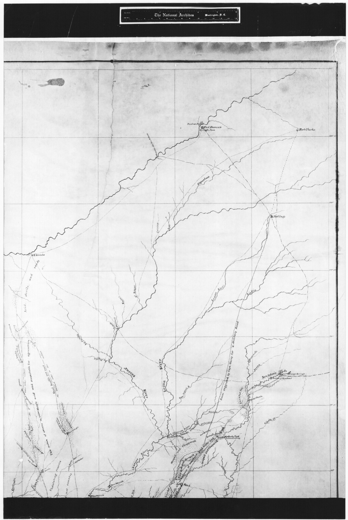
Sketch of a portion of the Texas Coast showing the relative positions of different harbours with the interior Military Posts, and the roads communicating with them, also two new routes from Black Point and Lamar to San Antonio
RL-1-10a
-
Map/Doc
72710
-
Collection
General Map Collection
-
Object Dates
1855 (Creation Date)
-
People and Organizations
R.B. Marcy (Compiler)
R.B. Marcy (Surveyor/Engineer)
R.B. Marcy (Author)
-
Subjects
Military
-
Height x Width
27.3 x 18.3 inches
69.3 x 46.5 cm
-
Comments
B/W photostat copy from National Archives in multiple pieces.
Part of: General Map Collection

Johnson County Sketch File 10a

Print $4.00
- Digital $50.00
Johnson County Sketch File 10a
1877
Size 6.7 x 10.6 inches
Map/Doc 28445
Map of Oakhurst

Print $20.00
- Digital $50.00
Map of Oakhurst
1899
Size 23.0 x 32.9 inches
Map/Doc 7556
Briscoe County Sketch File N

Print $40.00
- Digital $50.00
Briscoe County Sketch File N
Size 26.0 x 21.9 inches
Map/Doc 11012
Nueces County Sketch File 52

Print $10.00
- Digital $50.00
Nueces County Sketch File 52
1947
Size 14.1 x 8.6 inches
Map/Doc 32858
Presidio County Working Sketch 120

Print $20.00
- Digital $50.00
Presidio County Working Sketch 120
1984
Size 34.6 x 28.9 inches
Map/Doc 71797
Oil Development and Structural Map showing Schott, Mirando and other oil fields of the Laredo District with present and proposed development.

Print $20.00
- Digital $50.00
Oil Development and Structural Map showing Schott, Mirando and other oil fields of the Laredo District with present and proposed development.
Size 11.3 x 8.9 inches
Map/Doc 94107
Map of San Leon, Amos Edwards League, Galveston County, Texas

Print $20.00
- Digital $50.00
Map of San Leon, Amos Edwards League, Galveston County, Texas
1911
Size 22.9 x 14.1 inches
Map/Doc 3037
Amistad International Reservoir on Rio Grande Key Sheet

Print $20.00
- Digital $50.00
Amistad International Reservoir on Rio Grande Key Sheet
1960
Size 13.0 x 32.4 inches
Map/Doc 73345
Val Verde County Sketch File 5

Print $10.00
- Digital $50.00
Val Verde County Sketch File 5
1889
Size 11.3 x 8.4 inches
Map/Doc 39180
Dallas County Sketch File 7

Print $4.00
- Digital $50.00
Dallas County Sketch File 7
1858
Size 10.4 x 8.5 inches
Map/Doc 20408
Leon County Working Sketch 26

Print $20.00
- Digital $50.00
Leon County Working Sketch 26
1969
Size 43.1 x 46.9 inches
Map/Doc 70425
You may also like
Winkler County Working Sketch 7

Print $20.00
- Digital $50.00
Winkler County Working Sketch 7
1958
Size 45.4 x 30.2 inches
Map/Doc 72601
Flight Mission No. DCL-7C, Frame 69, Kenedy County

Print $20.00
- Digital $50.00
Flight Mission No. DCL-7C, Frame 69, Kenedy County
1943
Size 15.4 x 15.2 inches
Map/Doc 86055
McMullen County Working Sketch 8

Print $20.00
- Digital $50.00
McMullen County Working Sketch 8
1936
Size 27.2 x 33.0 inches
Map/Doc 70709
Anderson County Sketch File 32

Print $4.00
- Digital $50.00
Anderson County Sketch File 32
2002
Size 11.3 x 8.8 inches
Map/Doc 78312
Polk County Sketch File 13

Print $4.00
- Digital $50.00
Polk County Sketch File 13
Size 5.1 x 7.4 inches
Map/Doc 34150
Lavaca County Working Sketch 6

Print $20.00
- Digital $50.00
Lavaca County Working Sketch 6
1941
Size 20.8 x 22.0 inches
Map/Doc 70359
General Highway Map, Hidalgo County, Texas

Print $20.00
General Highway Map, Hidalgo County, Texas
1940
Size 18.4 x 24.7 inches
Map/Doc 79127
Map Illustrating the plan of the defences of the Western & North-Western Frontier, as proposed by Charles Gratiot in his report of Oct. 31, 1837

Print $20.00
- Digital $50.00
Map Illustrating the plan of the defences of the Western & North-Western Frontier, as proposed by Charles Gratiot in his report of Oct. 31, 1837
1837
Size 23.8 x 17.7 inches
Map/Doc 95698
City of Austin, Texas and Suburban Territory

Print $40.00
- Digital $50.00
City of Austin, Texas and Suburban Territory
1952
Size 52.9 x 47.2 inches
Map/Doc 73582
![91447, [Block K5], Twichell Survey Records](https://historictexasmaps.com/wmedia_w700/maps/91447-1.tif.jpg)
Grayson County Working Sketch 12

Print $20.00
- Digital $50.00
Grayson County Working Sketch 12
1951
Size 25.7 x 24.0 inches
Map/Doc 63251
Morris County Rolled Sketch 2A

Print $20.00
- Digital $50.00
Morris County Rolled Sketch 2A
Size 24.2 x 19.1 inches
Map/Doc 10243