Karnes County Sketch File 2
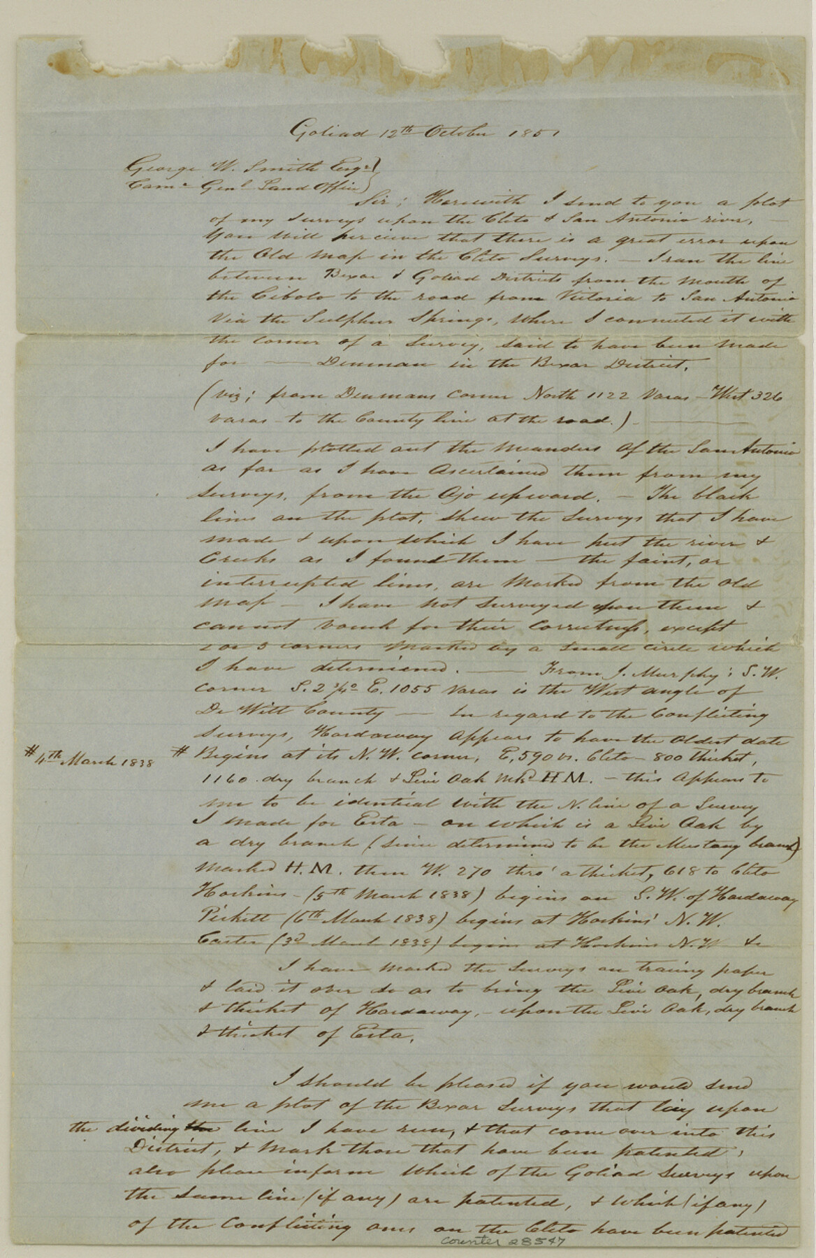
[Sketch showing survey conflicts on and around Cleto Creek]
-
Map/Doc
28547
-
Collection
General Map Collection
-
Object Dates
1851 (Creation Date)
1851/10/12 (Correspondence Date)
-
People and Organizations
Joseph H. Barnard (Surveyor/Engineer)
-
Counties
Karnes DeWitt
-
Subjects
Surveying Sketch File
-
Height x Width
12.5 x 8.1 inches
31.8 x 20.6 cm
-
Medium
paper, manuscript
-
Features
Cleto Creek
San Antonio River
Cibolo River
Road from Victoria to San Antonio
Sulphur Springs Road
Ojo Creek
Mustang Branch [of Cleto Creek]
West Fork of Cleto Creek
Dry Cleto Creek
Tonkewa Branch of Cleto Creek
Part of: General Map Collection
Dickens County Sketch File 14a

Print $20.00
- Digital $50.00
Dickens County Sketch File 14a
Size 18.2 x 16.5 inches
Map/Doc 11321
Armstrong County Rolled Sketch 4

Print $40.00
- Digital $50.00
Armstrong County Rolled Sketch 4
1876
Size 37.8 x 70.8 inches
Map/Doc 8426
Map of Travis County

Print $40.00
- Digital $50.00
Map of Travis County
1895
Size 48.8 x 54.1 inches
Map/Doc 82083
Flight Mission No. BRA-7M, Frame 189, Jefferson County

Print $20.00
- Digital $50.00
Flight Mission No. BRA-7M, Frame 189, Jefferson County
1953
Size 18.5 x 22.3 inches
Map/Doc 85557
Angelina County Sketch File 4

Print $4.00
- Digital $50.00
Angelina County Sketch File 4
1854
Size 8.3 x 9.0 inches
Map/Doc 12926
Field Notes of Mercer's Colony, Robertson, Nac[a]gdoches, Fannin, & Lamar Counties.
![1953, Field Notes of Mercer's Colony, Robertson, Nac[a]gdoches, Fannin, & Lamar Counties., General Map Collection](https://historictexasmaps.com/wmedia_w700/pdf_converted_jpg/qi_pdf_thumbnail_897.jpg)
Print $30.00
- Digital $50.00
Field Notes of Mercer's Colony, Robertson, Nac[a]gdoches, Fannin, & Lamar Counties.
1845
Size 9.5 x 14.8 inches
Map/Doc 1953
Old Miscellaneous File 23

Print $58.00
- Digital $50.00
Old Miscellaneous File 23
1919
Size 14.2 x 8.6 inches
Map/Doc 75600
Martin County Sketch File 10

Print $50.00
- Digital $50.00
Martin County Sketch File 10
Size 11.2 x 8.8 inches
Map/Doc 30644
Ector County Working Sketch 25

Print $20.00
- Digital $50.00
Ector County Working Sketch 25
1961
Size 29.6 x 34.2 inches
Map/Doc 68868
Carte d'une partie des Côtes de l'Inde depuis Bombay jus'qu'a Surate, avec le détail des Habitations de cette Côte

Print $20.00
- Digital $50.00
Carte d'une partie des Côtes de l'Inde depuis Bombay jus'qu'a Surate, avec le détail des Habitations de cette Côte
1782
Size 13.2 x 18.2 inches
Map/Doc 97119
Right of Way and Track Map International & Gt. Northern Ry. operated by the International & Gt. Northern Ry. Co., Columbia Branch, Gulf Division

Print $40.00
- Digital $50.00
Right of Way and Track Map International & Gt. Northern Ry. operated by the International & Gt. Northern Ry. Co., Columbia Branch, Gulf Division
1917
Size 25.1 x 56.7 inches
Map/Doc 64597
Flight Mission No. BRE-1P, Frame 9, Nueces County

Print $20.00
- Digital $50.00
Flight Mission No. BRE-1P, Frame 9, Nueces County
1956
Size 18.5 x 22.4 inches
Map/Doc 86617
You may also like

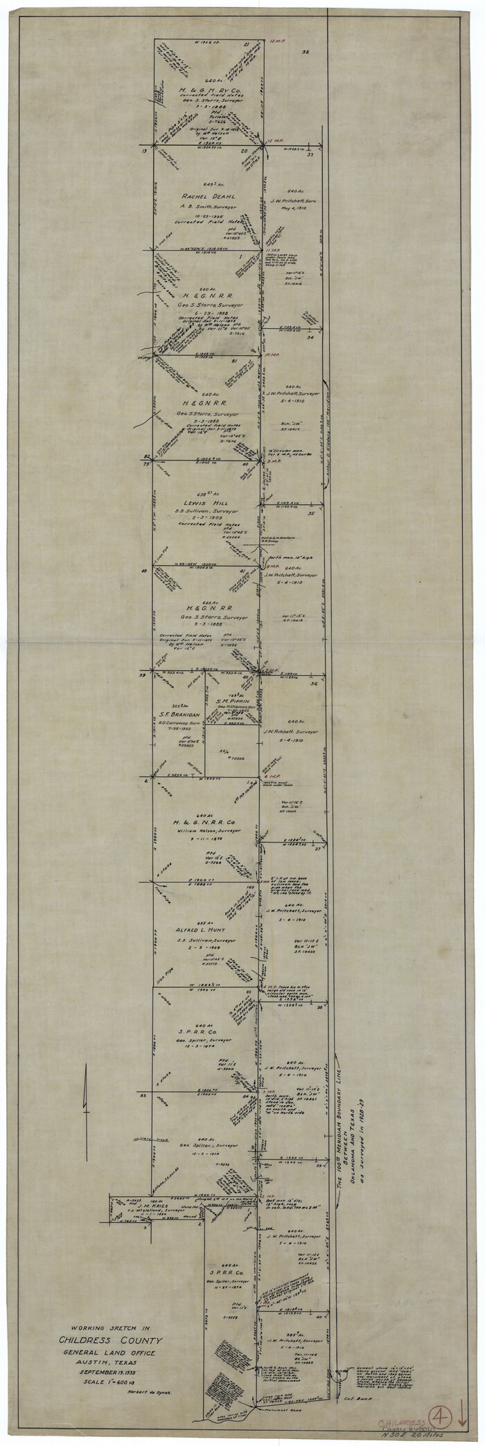
Childress County Working Sketch 4
Print $20.00
- Digital $50.00
Childress County Working Sketch 4
1939
Size 43.4 x 14.5 inches
Map/Doc 68020
Fisher County Boundary File 3

Print $32.00
- Digital $50.00
Fisher County Boundary File 3
Size 8.2 x 4.2 inches
Map/Doc 53428
Collin County Boundary File 2

Print $6.00
- Digital $50.00
Collin County Boundary File 2
Size 12.9 x 8.0 inches
Map/Doc 51682
Angelina County Working Sketch 25

Print $20.00
- Digital $50.00
Angelina County Working Sketch 25
1954
Size 25.0 x 17.5 inches
Map/Doc 67107
Nueces County Rolled Sketch 98B

Print $20.00
- Digital $50.00
Nueces County Rolled Sketch 98B
Size 33.5 x 32.7 inches
Map/Doc 9632
Cherokee County Sketch File 15

Print $6.00
- Digital $50.00
Cherokee County Sketch File 15
Size 12.4 x 8.0 inches
Map/Doc 18149
Scurry County Rolled Sketch 7

Print $20.00
- Digital $50.00
Scurry County Rolled Sketch 7
1946
Size 23.5 x 10.4 inches
Map/Doc 7767
Jeff Davis County Sketch File 7

Print $30.00
- Digital $50.00
Jeff Davis County Sketch File 7
1879
Size 12.8 x 8.1 inches
Map/Doc 27905
Flight Mission No. BRA-6M, Frame 146, Jefferson County

Print $20.00
- Digital $50.00
Flight Mission No. BRA-6M, Frame 146, Jefferson County
1953
Size 18.6 x 22.3 inches
Map/Doc 85447
Right-of-Way & Track Map, Houston and Brazos Valley Ry. Co. operated by the Houston and Brazos Valley Ry. Co.

Print $40.00
- Digital $50.00
Right-of-Way & Track Map, Houston and Brazos Valley Ry. Co. operated by the Houston and Brazos Valley Ry. Co.
1918
Size 24.7 x 56.7 inches
Map/Doc 64604
General Highway Map, Caldwell County, Texas

Print $20.00
General Highway Map, Caldwell County, Texas
1961
Size 18.3 x 24.6 inches
Map/Doc 79394